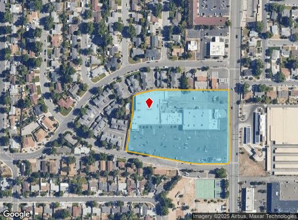
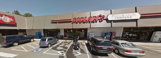
Property Record
800 Holman Way, Sparks, NV 89431


NEARBY LISTINGS FOR SALE OR LEASE
Property Detail
800 Holman Way
Reno, NV
Pyramid Park Sub No 1
027-342-11
PYRAMID PARK 1 FRAC PAR A, B, C BLK I
Commercialnec
Washoe
X
Nevada
32031C3045G
c
2025
6 AC
2026
West Sparks
002802
Reno/Sparks
73,408 SF
DEMOGRAPHICS near 800 Holman Way
1 Mile
3 Mile
5 Mile
2024 Total Population
23,966
109,990
232,470
2029 Population
25,098
115,978
244,426
Pop Growth 2024-2029
+ 4.72%
+ 5.44%
+ 5.14%
Average Age
38
38
38
2024 Total Households
9,043
42,429
92,297
HH Growth 2024-2029
+ 4.94%
+ 5.73%
+ 5.34%
Median Household Inc
$61,353
$58,243
$59,788
Avg Household Size
2.60
2.50
2.40
2024 Avg HH Vehicles
2.00
2.00
2.00
Median Home Value
$319,648
$349,627
$382,726
Median Year Built
1969
1982
1981
Nearby Places
Map Layers
Map Styles
 Street
 Aerial
- Restaurants
- Banks
- Shops
- Fitness
- Groceries
PUBLIC TRANSPORTATION
COMMUTER RAIL
Reno (California Zephyr - Amtrak)
DRIVE
WALK
Distance
Reno (California Zephyr - Amtrak)
10 min
5.1 mi
AIRPORT
Reno/Tahoe International
DRIVE
WALK
Distance
Reno/Tahoe International
28 min
9.0 mi
Freight Ports
Port of Stockton
DRIVE
WALK
Distance
Port of Stockton
213 min
183.2 mi
SALE & LEASE HISTORY
LISTING DATE
SALE/LEASE

Nov 18, 2016
For Lease
Nearby Properties
Address
Land Use
TOTAL SIZE
Lot Size
Zoning
Address
Land Use
TOTAL SIZE
Lot Size
Zoning
2,041,608 SF
28.47 AC
MU
Address
Land Use
TOTAL SIZE
Lot Size
Zoning
1,103,124 SF
138.61 AC
MU
Address
Land Use
TOTAL SIZE
Lot Size
Zoning
1,048,514 SF
1.30 AC
MU
Address
Land Use
TOTAL SIZE
Lot Size
Zoning
385,812 SF
16.47 AC
NUD
Address
Land Use
TOTAL SIZE
Lot Size
Zoning
991,800 SF
51.03 AC
PD
Address
Land Use
TOTAL SIZE
Lot Size
Zoning
294,872 SF
69.02 AC
PF
Address
Land Use
TOTAL SIZE
Lot Size
Zoning
296,048 SF
93.65 AC
PF
Address
Land Use
TOTAL SIZE
Lot Size
Zoning
356,160 SF
12.05 AC
MUD
Address
Land Use
TOTAL SIZE
Lot Size
Zoning
347,564 SF
10.23 AC
MUD
Address
Land Use
TOTAL SIZE
Lot Size
Zoning
460,688 SF
62.55 AC
PF
Address
Land Use
TOTAL SIZE
Lot Size
Zoning
342,947 SF
8.95 AC
MF30
Address
Land Use
TOTAL SIZE
Lot Size
Zoning
321,941 SF
36 AC
NUD
Address
Land Use
TOTAL SIZE
Lot Size
Zoning
365,962 SF
3.54 AC
PD
Address
Land Use
TOTAL SIZE
Lot Size
Zoning
600 SF
279.66 AC
ME 61% / P
Address
Land Use
TOTAL SIZE
Lot Size
Zoning
617,081 SF
2.62 AC
MUD
Address
Land Use
TOTAL SIZE
Lot Size
Zoning
279,596 SF
10.94 AC
NUD
Address
Land Use
TOTAL SIZE
Lot Size
Zoning
264,533 SF
37 AC
PF
Address
Land Use
TOTAL SIZE
Lot Size
Zoning
160,292 SF
1.66 AC
MF30
Address
Land Use
TOTAL SIZE
Lot Size
Zoning
246,076 SF
16.43 AC
PD
Address
Land Use
TOTAL SIZE
Lot Size
Zoning
622,628 SF
2.91 AC
MUD
Address
Land Use
TOTAL SIZE
Lot Size
Zoning
79,748 SF
8.98 AC
NUD
Address
Land Use
TOTAL SIZE
Lot Size
Zoning
232,481 SF
9.45 AC
PD
Address
Land Use
TOTAL SIZE
Lot Size
Zoning
273,101 SF
15.96 AC
MF-3/PUD
Address
Land Use
TOTAL SIZE
Lot Size
Zoning
249,916 SF
17.68 AC
MF30
Address
Land Use
TOTAL SIZE
Lot Size
Zoning
207,353 SF
11.32 AC
MF30
Address
Land Use
TOTAL SIZE
Lot Size
Zoning
34,503 SF
30.82 AC
PF
Address
Land Use
TOTAL SIZE
Lot Size
Zoning
242,907 SF
4.18 AC
NUD
Address
Land Use
TOTAL SIZE
Lot Size
Zoning
258,793 SF
14.86 AC
MF-3
Address
Land Use
TOTAL SIZE
Lot Size
Zoning
203,367 SF
1 AC
MUD
Address
Land Use
TOTAL SIZE
Lot Size
Zoning
184,240 SF
22.65 AC
I
The World's #1 Commercial Real Estate Marketplace
Connect with us
© 2026 CoStar Group
The information above has been obtained from sources believed reliable. While we do not doubt its accuracy we have not verified it and make no guarantee, warranty or representation about it. It is your responsibility to independently confirm its accuracy and completeness. Any projections, opinions, assumptions, or estimates used are for example only and do not represent the current or future performance of the property. The value of this transaction to you depends on tax and other factors which should be evaluated by your tax, financial, and legal advisors. You and your advisors should conduct a careful, independent investigation of the property to determine to your satisfaction the suitability of the property for your needs.