Property Record
800 N 46Th St, Killeen, TX 76543
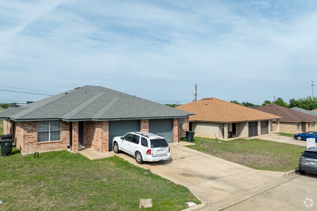

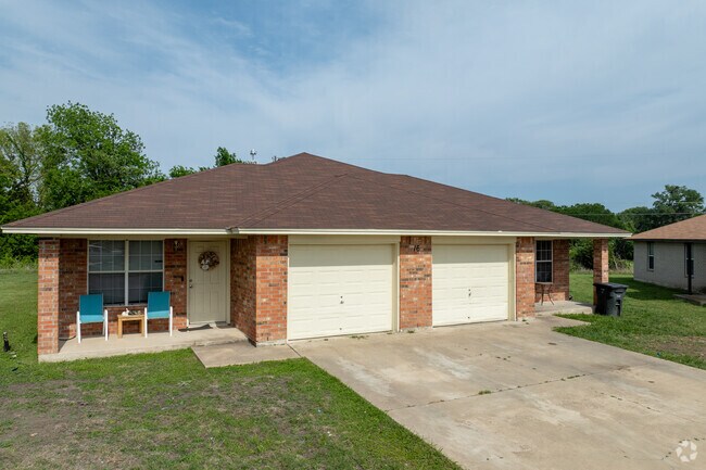
Property Detail
800 N 46Th St
Killeen-Temple, TX
NORTHCLIFF ADDITION REPLAT & 4.114AC OF A DICKSON/A0266, BLOCK 001, LOT 0002, & BUSINESS PERSONAL PROPERTY,, ACRES 9.278
332704
Bell
Multifamilydwelling
Texas
AE The base floodplain where base flood elevations are provided. AE Zones are now used on new format FIRMs instead of A1-A30 Zones.
2
2025
9.28 AC
2025
Killeen/Fort Hood
022200
Killeen/Temple/Fort Hood
89,340 SF
NEARBY LISTINGS FOR SALE OR LEASE
DEMOGRAPHICS near 800 N 46Th St
1 mile
3 mile
5 mile
2025 Total Population
11,428
67,189
148,291
2030 Population
12,217
71,650
156,873
Pop Growth 2025-2030
+ 6.90%
+ 6.64%
+ 5.79%
Average Age
34
35
34
2025 Total Households
5,081
27,507
55,800
HH Growth 2025-2030
+ 7.07%
+ 6.86%
+ 6.01%
Median Household Inc
$51,786
$48,038
$59,137
Avg Household Size
2.20
2.30
2.50
2025 Avg HH Vehicles
1.00
2.00
2.00
Median Home Value
$139,492
$152,970
$212,868
Median Year Built
1982
1982
1989
Nearby Places
Map Layers
Map Styles
 Street
 Aerial
Layers
 Traffic
 Biking
Places
Listings with unknown addresses are not visible on the map
- Restaurants
- Banks
- Shops
- Fitness
- Groceries
PUBLIC TRANSPORTATION
AIRPORT
Killeen Municipal
Drive
Walk
Distance
Killeen Municipal
10 min
4.3 mi
Robert Gray AAF
Drive
Walk
Distance
Robert Gray AAF
26 min
14.0 mi
Freight Ports
Port of Houston
Drive
Walk
Distance
Port of Houston
258 min
201.0 mi
Nearby Properties
Address
Land Use
TOTAL SIZE
Lot Size
Zoning
Address
Land Use
TOTAL SIZE
Lot Size
Zoning
4 SF
55.08 AC
Address
Land Use
TOTAL SIZE
Lot Size
Zoning
1 SF
7.81 AC
Address
Land Use
TOTAL SIZE
Lot Size
Zoning
194,952 SF
38.61 AC
Address
Land Use
TOTAL SIZE
Lot Size
Zoning
233,807 SF
16.12 AC
Address
Land Use
TOTAL SIZE
Lot Size
Zoning
Address
Land Use
TOTAL SIZE
Lot Size
Zoning
200,345 SF
42.44 AC
CUP
Address
Land Use
TOTAL SIZE
Lot Size
Zoning
464,093 SF
71.50 AC
Address
Land Use
TOTAL SIZE
Lot Size
Zoning
133,210 SF
8.52 AC
R-3
Address
Land Use
TOTAL SIZE
Lot Size
Zoning
160,143 SF
13.30 AC
Address
Land Use
TOTAL SIZE
Lot Size
Zoning
151,969 SF
10 AC
R-3
Address
Land Use
TOTAL SIZE
Lot Size
Zoning
13,000 SF
31.72 AC
Address
Land Use
TOTAL SIZE
Lot Size
Zoning
46,892 SF
2.48 AC
Address
Land Use
TOTAL SIZE
Lot Size
Zoning
154,910 SF
9.38 AC
Address
Land Use
TOTAL SIZE
Lot Size
Zoning
386,344 SF
171.40 AC
B-5
Address
Land Use
TOTAL SIZE
Lot Size
Zoning
132,202 SF
11.52 AC
R-3
Address
Land Use
TOTAL SIZE
Lot Size
Zoning
133,648 SF
6.52 AC
Address
Land Use
TOTAL SIZE
Lot Size
Zoning
62,226 SF
0.68 AC
Address
Land Use
TOTAL SIZE
Lot Size
Zoning
108,964 SF
4.50 AC
Address
Land Use
TOTAL SIZE
Lot Size
Zoning
114,585 SF
4.64 AC
Address
Land Use
TOTAL SIZE
Lot Size
Zoning
121,285 SF
11.75 AC
Address
Land Use
TOTAL SIZE
Lot Size
Zoning
162,090 SF
8.28 AC
R-3
Address
Land Use
TOTAL SIZE
Lot Size
Zoning
366,112 SF
44.17 AC
Address
Land Use
TOTAL SIZE
Lot Size
Zoning
228,165 SF
22.43 AC
Address
Land Use
TOTAL SIZE
Lot Size
Zoning
120,948 SF
32.68 AC
Address
Land Use
TOTAL SIZE
Lot Size
Zoning
152,393 SF
9.78 AC
Address
Land Use
TOTAL SIZE
Lot Size
Zoning
91,475 SF
11.33 AC
Address
Land Use
TOTAL SIZE
Lot Size
Zoning
126,152 SF
8 AC
B-5
Address
Land Use
TOTAL SIZE
Lot Size
Zoning
57,219 SF
10.35 AC
Address
Land Use
TOTAL SIZE
Lot Size
Zoning
117,988 SF
7.77 AC
Address
Land Use
TOTAL SIZE
Lot Size
Zoning
1 SF
13.02 AC
The World's #1 Commercial Real Estate Marketplace
Connect with us
© 2026 CoStar Group
The information above has been obtained from sources believed reliable. While we do not doubt its accuracy we have not verified it and make no guarantee, warranty or representation about it. It is your responsibility to independently confirm its accuracy and completeness. Any projections, opinions, assumptions, or estimates used are for example only and do not represent the current or future performance of the property. The value of this transaction to you depends on tax and other factors which should be evaluated by your tax, financial, and legal advisors. You and your advisors should conduct a careful, independent investigation of the property to determine to your satisfaction the suitability of the property for your needs.