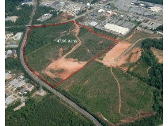
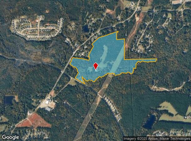
Property Record
800 N Davis Rd, Lagrange, GA 30241
NEARBY LISTINGS FOR SALE OR LEASE
Property Detail
800 N Davis Rd
049-1D-000-047
Davis
Privatepreserveopenspacevacantlandforestlandconservation
800 N DAVIS RD/ HAMMETT RD LL24-40-41 LD-6TH
AE
Troup
13285C0153E
Georgia
2024
72.90 AC
2025
Troup County
960600
Columbus GA
3,000 SF
LaGrange, GA-AL
DEMOGRAPHICS near 800 N Davis Rd
1 mile
3 mile
5 mile
2024 Total Population
772
15,944
34,762
2029 Population
770
16,042
35,403
Pop Growth 2024-2029
(0.26%)
+ 0.61%
+ 1.84%
Average Age
37
37
38
2024 Total Households
313
6,358
13,510
HH Growth 2024-2029
(0.32%)
+ 0.60%
+ 1.86%
Median Household Inc
$46,062
$45,006
$46,198
Avg Household Size
2.50
2.50
2.50
2024 Avg HH Vehicles
2.00
2.00
2.00
Median Home Value
$169,374
$163,751
$167,080
Median Year Built
1986
1985
1982
Nearby Places
Map Layers
Map Styles
 Street
 Aerial
Transit
 Traffic
 Biking
Places
Listings with unknown addresses are not visible on the map
- Restaurants
- Banks
- Shops
- Fitness
- Groceries
Nearby Properties
Address
Land Use
TOTAL SIZE
Lot Size
Zoning
Address
Land Use
TOTAL SIZE
Lot Size
Zoning
117,684 SF
12.61 AC
16- AC-MX
Address
Land Use
TOTAL SIZE
Lot Size
Zoning
121,889 SF
8.99 AC
16- CR-MX
Address
Land Use
TOTAL SIZE
Lot Size
Zoning
191,357 SF
89.77 AC
01-SFMD
Address
Land Use
TOTAL SIZE
Lot Size
Zoning
2,152 SF
21.70 AC
16- CR-MR
Address
Land Use
TOTAL SIZE
Lot Size
Zoning
141,328 SF
7.18 AC
16- TN-MX
Address
Land Use
TOTAL SIZE
Lot Size
Zoning
8,448 SF
25.78 AC
16- CR-MX
Address
Land Use
TOTAL SIZE
Lot Size
Zoning
3,798 SF
22.81 AC
16- CR-MR
Address
Land Use
TOTAL SIZE
Lot Size
Zoning
138,573 SF
59.91 AC
01-SFMD
Address
Land Use
TOTAL SIZE
Lot Size
Zoning
56,620 SF
5.22 AC
16- CR-MX
Address
Land Use
TOTAL SIZE
Lot Size
Zoning
22,600 SF
15.57 AC
16- CR-MX
Address
Land Use
TOTAL SIZE
Lot Size
Zoning
3,433 SF
19.65 AC
16- CR-MR
Address
Land Use
TOTAL SIZE
Lot Size
Zoning
8,752 SF
13.43 AC
16- CR-MR
Address
Land Use
TOTAL SIZE
Lot Size
Zoning
92,762 SF
61.32 AC
01-SFMD
Address
Land Use
TOTAL SIZE
Lot Size
Zoning
92,762 SF
78.28 AC
16- SU-R
Address
Land Use
TOTAL SIZE
Lot Size
Zoning
993 SF
1,844 AC
01-SFMD
Address
Land Use
TOTAL SIZE
Lot Size
Zoning
112,950 SF
15.47 AC
16- CR-MX
Address
Land Use
TOTAL SIZE
Lot Size
Zoning
26,150 SF
3.28 AC
16- CR-MX
Address
Land Use
TOTAL SIZE
Lot Size
Zoning
8,424 SF
11 AC
16- CR-MR
Address
Land Use
TOTAL SIZE
Lot Size
Zoning
1,792 SF
15.02 AC
16- CP-GB
Address
Land Use
TOTAL SIZE
Lot Size
Zoning
218,488 SF
32.40 AC
16- CR-MX
Address
Land Use
TOTAL SIZE
Lot Size
Zoning
34,380 SF
59.74 AC
16- CR-MX
Address
Land Use
TOTAL SIZE
Lot Size
Zoning
125,467 SF
35.19 AC
16- CR-MX
Address
Land Use
TOTAL SIZE
Lot Size
Zoning
9,478 SF
3.98 AC
16- CR-MX
Address
Land Use
TOTAL SIZE
Lot Size
Zoning
16,916 SF
15.33 AC
16- SU-R
Address
Land Use
TOTAL SIZE
Lot Size
Zoning
27,000 SF
12.70 AC
16- CP-GB
Address
Land Use
TOTAL SIZE
Lot Size
Zoning
35,512 SF
2.64 AC
16- CR-MX
Address
Land Use
TOTAL SIZE
Lot Size
Zoning
7,780 SF
9.65 AC
16- CR-MR
Address
Land Use
TOTAL SIZE
Lot Size
Zoning
24,317 SF
4.87 AC
16- CR-MX
Address
Land Use
TOTAL SIZE
Lot Size
Zoning
52,148 SF
7.33 AC
16- CR-MX
Address
Land Use
TOTAL SIZE
Lot Size
Zoning
56,992 SF
4.44 AC
16- CR-MX
The World's #1 Commercial Real Estate Marketplace
Connect with us
© 2026 CoStar Group
The information above has been obtained from sources believed reliable. While we do not doubt its accuracy we have not verified it and make no guarantee, warranty or representation about it. It is your responsibility to independently confirm its accuracy and completeness. Any projections, opinions, assumptions, or estimates used are for example only and do not represent the current or future performance of the property. The value of this transaction to you depends on tax and other factors which should be evaluated by your tax, financial, and legal advisors. You and your advisors should conduct a careful, independent investigation of the property to determine to your satisfaction the suitability of the property for your needs.