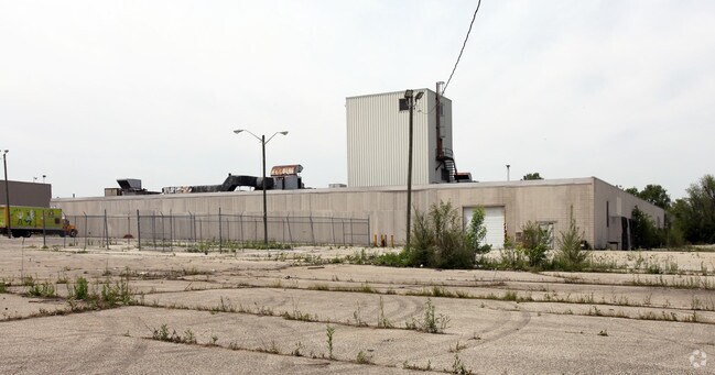
Property Record
800 N Sherman Dr, Indianapolis, IN 46201
NEARBY LISTINGS FOR SALE OR LEASE
Property Detail
800 N Sherman Dr
Indianapolis-Carmel-Anderson, IN
Perkins Sherman Drive Add
49-10-05-136-001.000-101
X 70.00 X 70.00 BEG 69.11 W & 1.55 S OF NE COR L9 1.884 AC.
Lightindustrial
Marion
X
Indiana
18097C0163F
11
2023
1.88 AC
2024
Willard Park
354900
Indianapolis
71,800 SF
DEMOGRAPHICS near 800 N Sherman Dr
1 Mile
3 Mile
5 Mile
2024 Total Population
22,949
127,508
278,260
2029 Population
23,366
128,975
280,467
Pop Growth 2024-2029
+ 1.82%
+ 1.15%
+ 0.79%
Average Age
36
37
37
2024 Total Households
9,332
56,577
120,109
HH Growth 2024-2029
+ 1.65%
+ 1.05%
+ 0.79%
Median Household Inc
$39,288
$49,829
$47,979
Avg Household Size
2.30
2.10
2.20
2024 Avg HH Vehicles
1.00
1.00
1.00
Median Home Value
$107,080
$164,074
$154,633
Median Year Built
1946
1951
1955
Nearby Places
Map Layers
Map Styles
 Street
 Aerial
- Restaurants
- Banks
- Shops
- Fitness
- Groceries
PUBLIC TRANSPORTATION
COMMUTER RAIL
Indianapolis (Cardinal - Amtrak)
DRIVE
WALK
Distance
Indianapolis (Cardinal - Amtrak)
8 min
4.5 mi
AIRPORT
Indianapolis International
DRIVE
WALK
Distance
Indianapolis International
31 min
17.2 mi
Freight Ports
Port of Toledo
DRIVE
WALK
Distance
Port of Toledo
267 min
223.3 mi
Nearby Properties
Address
Land Use
TOTAL SIZE
Lot Size
Zoning
Address
Land Use
TOTAL SIZE
Lot Size
Zoning
5.59 AC
ZO01
Address
Land Use
TOTAL SIZE
Lot Size
Zoning
23,200 SF
1.71 AC
Address
Land Use
TOTAL SIZE
Lot Size
Zoning
41.83 AC
ZO01
Address
Land Use
TOTAL SIZE
Lot Size
Zoning
302,187 SF
1.97 AC
ZO01
Address
Land Use
TOTAL SIZE
Lot Size
Zoning
1,202,700 SF
77.25 AC
ZO01
Address
Land Use
TOTAL SIZE
Lot Size
Zoning
25,146 SF
28.58 AC
ZO01
Address
Land Use
TOTAL SIZE
Lot Size
Zoning
500,908 SF
10.36 AC
ZO01
Address
Land Use
TOTAL SIZE
Lot Size
Zoning
19,896 SF
32.59 AC
ZO01
Address
Land Use
TOTAL SIZE
Lot Size
Zoning
384,520 SF
1.93 AC
ZO01
Address
Land Use
TOTAL SIZE
Lot Size
Zoning
21,809 SF
1.57 AC
ZO01
Address
Land Use
TOTAL SIZE
Lot Size
Zoning
36,000 SF
0.94 AC
ZO01
Address
Land Use
TOTAL SIZE
Lot Size
Zoning
309,006 SF
1.48 AC
ZO01
Address
Land Use
TOTAL SIZE
Lot Size
Zoning
47.10 AC
ZO01
Address
Land Use
TOTAL SIZE
Lot Size
Zoning
217,895 SF
3.43 AC
ZO01
Address
Land Use
TOTAL SIZE
Lot Size
Zoning
245,608 SF
0.90 AC
Address
Land Use
TOTAL SIZE
Lot Size
Zoning
11,230 SF
0.53 AC
ZO02
Address
Land Use
TOTAL SIZE
Lot Size
Zoning
179,381 SF
2.11 AC
ZO01
Address
Land Use
TOTAL SIZE
Lot Size
Zoning
4,761 SF
3.65 AC
ZO01
Address
Land Use
TOTAL SIZE
Lot Size
Zoning
12,900 SF
2 AC
ZO01
Address
Land Use
TOTAL SIZE
Lot Size
Zoning
414,000 SF
1.64 AC
ZO01
Address
Land Use
TOTAL SIZE
Lot Size
Zoning
31,413 SF
3.91 AC
ZO01
Address
Land Use
TOTAL SIZE
Lot Size
Zoning
3.32 AC
ZO01
Address
Land Use
TOTAL SIZE
Lot Size
Zoning
194,488 SF
2.02 AC
ZO01
Address
Land Use
TOTAL SIZE
Lot Size
Zoning
531,996 SF
9.09 AC
ZO01
Address
Land Use
TOTAL SIZE
Lot Size
Zoning
18,320 SF
2.05 AC
ZO01
Address
Land Use
TOTAL SIZE
Lot Size
Zoning
22,656 SF
4.05 AC
ZO01
Address
Land Use
TOTAL SIZE
Lot Size
Zoning
4,564 SF
2.32 AC
ZO01
Address
Land Use
TOTAL SIZE
Lot Size
Zoning
90,118 SF
1.27 AC
ZO01
Address
Land Use
TOTAL SIZE
Lot Size
Zoning
3.64 AC
ZO01
Address
Land Use
TOTAL SIZE
Lot Size
Zoning
121,309 SF
1.37 AC
ZO01
The World's #1 Commercial Real Estate Marketplace
Connect with us
© 2026 CoStar Group
The information above has been obtained from sources believed reliable. While we do not doubt its accuracy we have not verified it and make no guarantee, warranty or representation about it. It is your responsibility to independently confirm its accuracy and completeness. Any projections, opinions, assumptions, or estimates used are for example only and do not represent the current or future performance of the property. The value of this transaction to you depends on tax and other factors which should be evaluated by your tax, financial, and legal advisors. You and your advisors should conduct a careful, independent investigation of the property to determine to your satisfaction the suitability of the property for your needs.