Property Record
800 Nave Rd Se, Massillon, OH 44646

Save to a Folder
{{folder.Name}}
{{folder.ListingIds.length}} Properties
{{folder.ListingIds.length}} Property
Create a New Folder
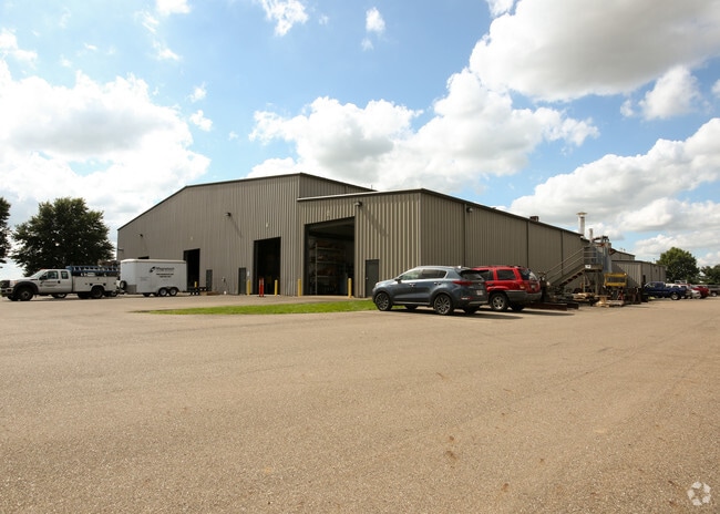
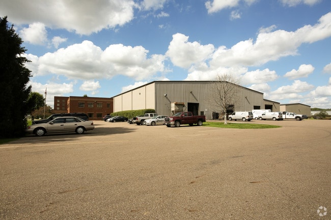
Property Detail
800 Nave Rd Se
00616775
OL 598 9.73A
Lightindustrial
Stark
B and X Area of moderate flood hazard, usually the area between the limits of the 100-year and 500-year floods.
Ohio
0
9.73 AC
2025
Stark County
714400
Cleveland
84,704 SF
Canton-Massillon, OH
NEARBY LISTINGS FOR SALE OR LEASE
DEMOGRAPHICS near 800 Nave Rd Se
1 mile
3 mile
5 mile
2025 Total Population
553
31,376
73,249
2030 Population
557
31,691
73,207
Pop Growth 2025-2030
+ 0.72%
+ 1.00%
(0.06%)
Average Age
42
42
43
2025 Total Households
207
13,236
31,047
HH Growth 2025-2030
+ 0.48%
+ 1.06%
(0.07%)
Median Household Inc
$46,759
$55,743
$60,733
Avg Household Size
2.50
2.30
2.30
2025 Avg HH Vehicles
2.00
2.00
2.00
Median Home Value
$150,000
$143,607
$163,898
Median Year Built
1990
1955
1963
Nearby Places
Map Layers
Map Styles
 Street
 Aerial
Layers
 Traffic
 Biking
Places
Listings with unknown addresses are not visible on the map
- Restaurants
- Banks
- Shops
- Fitness
- Groceries
PUBLIC TRANSPORTATION
AIRPORT
Akron-Canton Regional
Drive
Walk
Distance
Akron-Canton Regional
26 min
14.1 mi
Freight Ports
Port of Toledo
Drive
Walk
Distance
Port of Toledo
184 min
154.7 mi
SALE & LEASE HISTORY
LISTING DATE
SALE/LEASE

Sep 23, 2016
For Sale
Nearby Properties
Address
Land Use
TOTAL SIZE
Lot Size
Zoning
Address
Land Use
TOTAL SIZE
Lot Size
Zoning
417,003 SF
35.79 AC
Address
Land Use
TOTAL SIZE
Lot Size
Zoning
287,504 SF
54.58 AC
Address
Land Use
TOTAL SIZE
Lot Size
Zoning
693,236 SF
Address
Land Use
TOTAL SIZE
Lot Size
Zoning
1,160,888 SF
58.06 AC
Address
Land Use
TOTAL SIZE
Lot Size
Zoning
310,252 SF
55.48 AC
Address
Land Use
TOTAL SIZE
Lot Size
Zoning
276,484 SF
21.51 AC
Address
Land Use
TOTAL SIZE
Lot Size
Zoning
215,273 SF
31.35 AC
Address
Land Use
TOTAL SIZE
Lot Size
Zoning
188,816 SF
34.72 AC
Address
Land Use
TOTAL SIZE
Lot Size
Zoning
175,847 SF
31.71 AC
Address
Land Use
TOTAL SIZE
Lot Size
Zoning
290,926 SF
43.11 AC
Address
Land Use
TOTAL SIZE
Lot Size
Zoning
96,277 SF
13.51 AC
Address
Land Use
TOTAL SIZE
Lot Size
Zoning
208,780 SF
40.77 AC
Address
Land Use
TOTAL SIZE
Lot Size
Zoning
216,760 SF
15.51 AC
Address
Land Use
TOTAL SIZE
Lot Size
Zoning
702,000 SF
49.45 AC
Address
Land Use
TOTAL SIZE
Lot Size
Zoning
492,780 SF
21.73 AC
Address
Land Use
TOTAL SIZE
Lot Size
Zoning
174,284 SF
12.98 AC
Address
Land Use
TOTAL SIZE
Lot Size
Zoning
228,545 SF
19.07 AC
Address
Land Use
TOTAL SIZE
Lot Size
Zoning
186,091 SF
15.67 AC
Address
Land Use
TOTAL SIZE
Lot Size
Zoning
118,943 SF
10.51 AC
Address
Land Use
TOTAL SIZE
Lot Size
Zoning
63,324 SF
5.93 AC
Address
Land Use
TOTAL SIZE
Lot Size
Zoning
69,514 SF
22.98 AC
Address
Land Use
TOTAL SIZE
Lot Size
Zoning
509,280 SF
73.57 AC
Address
Land Use
TOTAL SIZE
Lot Size
Zoning
306,616 SF
5.80 AC
Address
Land Use
TOTAL SIZE
Lot Size
Zoning
67,056 SF
1.91 AC
Address
Land Use
TOTAL SIZE
Lot Size
Zoning
79,092 SF
1.29 AC
Address
Land Use
TOTAL SIZE
Lot Size
Zoning
140,818 SF
12.09 AC
Address
Land Use
TOTAL SIZE
Lot Size
Zoning
71,540 SF
7.44 AC
Address
Land Use
TOTAL SIZE
Lot Size
Zoning
96,944 SF
12.84 AC
Address
Land Use
TOTAL SIZE
Lot Size
Zoning
70,544 SF
3.43 AC
Address
Land Use
TOTAL SIZE
Lot Size
Zoning
48,994 SF
4.39 AC
The World's #1 Commercial Real Estate Marketplace
Connect with us
© 2026 CoStar Group
The information above has been obtained from sources believed reliable. While we do not doubt its accuracy we have not verified it and make no guarantee, warranty or representation about it. It is your responsibility to independently confirm its accuracy and completeness. Any projections, opinions, assumptions, or estimates used are for example only and do not represent the current or future performance of the property. The value of this transaction to you depends on tax and other factors which should be evaluated by your tax, financial, and legal advisors. You and your advisors should conduct a careful, independent investigation of the property to determine to your satisfaction the suitability of the property for your needs.