Property Record
800 Northside Dr, Moultrie, GA 31768
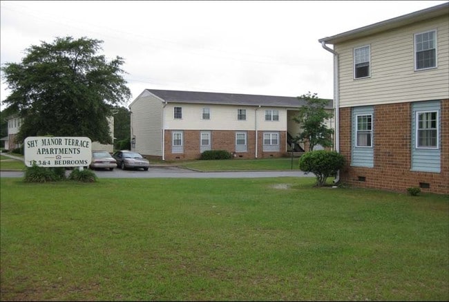

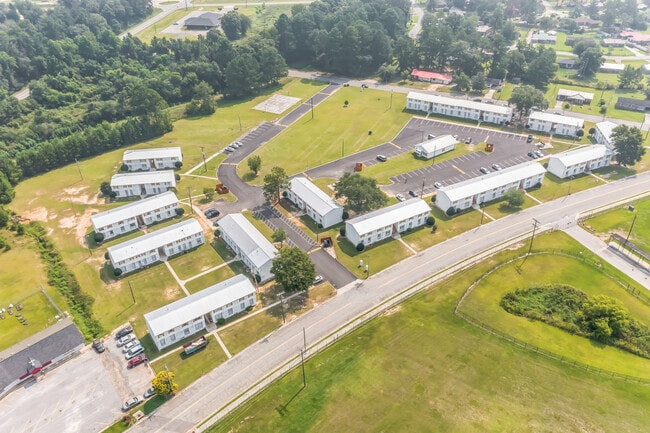

Property Detail
800 Northside Dr
M001-005
LL 244 8TH LD SHY MANOR TERRACE APTS
Apartment
Colquitt
AE The base floodplain where base flood elevations are provided. AE Zones are now used on new format FIRMs instead of A1-A30 Zones.
Georgia
2025
10.05 AC
2025
Albany/Southwest
970301
Other Market Areas
9,396 SF
Moultrie, GA
NEARBY LISTINGS FOR SALE OR LEASE
-
-
-
No Photo
-
View all Moultrie listings for sale on LoopNet.com
DEMOGRAPHICS near 800 Northside Dr
1 mile
3 mile
5 mile
2025 Total Population
3,707
16,262
25,197
2030 Population
3,898
16,818
25,953
Pop Growth 2025-2030
+ 5.15%
+ 3.42%
+ 3.00%
Average Age
37
38
39
2025 Total Households
1,464
6,188
9,581
HH Growth 2025-2030
+ 5.26%
+ 3.46%
+ 3.00%
Median Household Inc
$31,666
$40,183
$44,546
Avg Household Size
2.40
2.50
2.50
2025 Avg HH Vehicles
1.00
2.00
2.00
Median Home Value
$74,707
$133,780
$153,632
Median Year Built
1971
1972
1978
Nearby Places
Map Layers
Map Styles
 Street
 Aerial
Layers
 Traffic
 Biking
Places
Listings with unknown addresses are not visible on the map
- Restaurants
- Banks
- Shops
- Fitness
- Groceries
SALE & LEASE HISTORY
LISTING DATE
SALE/LEASE

Sep 13, 2023
For Sale
Nov 01, 2018
For Sale
May 24, 2018
For Sale
Nearby Properties
Address
Land Use
TOTAL SIZE
Lot Size
Zoning
Address
Land Use
TOTAL SIZE
Lot Size
Zoning
38,268 SF
2.07 AC
Address
Land Use
TOTAL SIZE
Lot Size
Zoning
73.72 AC
Address
Land Use
TOTAL SIZE
Lot Size
Zoning
24.25 AC
Address
Land Use
TOTAL SIZE
Lot Size
Zoning
21,678 SF
5.75 AC
Address
Land Use
TOTAL SIZE
Lot Size
Zoning
112.93 AC
COMMERCIAL
Address
Land Use
TOTAL SIZE
Lot Size
Zoning
21,866 SF
1.44 AC
Address
Land Use
TOTAL SIZE
Lot Size
Zoning
15.56 AC
Address
Land Use
TOTAL SIZE
Lot Size
Zoning
2,606 SF
15 AC
Address
Land Use
TOTAL SIZE
Lot Size
Zoning
17,574 SF
1.59 AC
Address
Land Use
TOTAL SIZE
Lot Size
Zoning
149,407 SF
15.29 AC
Address
Land Use
TOTAL SIZE
Lot Size
Zoning
111,860 SF
13.50 AC
002
Address
Land Use
TOTAL SIZE
Lot Size
Zoning
105,612 SF
13.19 AC
002
Address
Land Use
TOTAL SIZE
Lot Size
Zoning
18,096 SF
12.13 AC
Address
Land Use
TOTAL SIZE
Lot Size
Zoning
61,200 SF
9.50 AC
Address
Land Use
TOTAL SIZE
Lot Size
Zoning
189,470 SF
12.68 AC
Address
Land Use
TOTAL SIZE
Lot Size
Zoning
90,694 SF
19.17 AC
Address
Land Use
TOTAL SIZE
Lot Size
Zoning
27,217 SF
20.32 AC
Address
Land Use
TOTAL SIZE
Lot Size
Zoning
9,916 SF
6.24 AC
002
Address
Land Use
TOTAL SIZE
Lot Size
Zoning
21,574 SF
1.11 AC
Address
Land Use
TOTAL SIZE
Lot Size
Zoning
64,840 SF
9 AC
Address
Land Use
TOTAL SIZE
Lot Size
Zoning
2,614 SF
8.30 AC
Address
Land Use
TOTAL SIZE
Lot Size
Zoning
41,170 SF
1.63 AC
Address
Land Use
TOTAL SIZE
Lot Size
Zoning
36,782 SF
300.68 AC
Address
Land Use
TOTAL SIZE
Lot Size
Zoning
38,848 SF
0.52 AC
Address
Land Use
TOTAL SIZE
Lot Size
Zoning
36,355 SF
7.08 AC
Address
Land Use
TOTAL SIZE
Lot Size
Zoning
7,404 SF
3.66 AC
Address
Land Use
TOTAL SIZE
Lot Size
Zoning
16.27 AC
Address
Land Use
TOTAL SIZE
Lot Size
Zoning
13,638 SF
3.29 AC
Address
Land Use
TOTAL SIZE
Lot Size
Zoning
68,600 SF
11.95 AC
The World's #1 Commercial Real Estate Marketplace
Connect with us
© 2026 CoStar Group
The information above has been obtained from sources believed reliable. While we do not doubt its accuracy we have not verified it and make no guarantee, warranty or representation about it. It is your responsibility to independently confirm its accuracy and completeness. Any projections, opinions, assumptions, or estimates used are for example only and do not represent the current or future performance of the property. The value of this transaction to you depends on tax and other factors which should be evaluated by your tax, financial, and legal advisors. You and your advisors should conduct a careful, independent investigation of the property to determine to your satisfaction the suitability of the property for your needs.