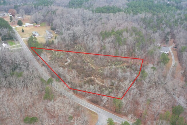
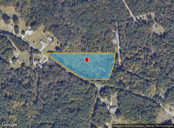
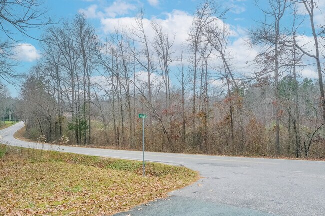
Property Record
800 Union Rd, Matthews, NC 28104
NEARBY LISTINGS FOR SALE OR LEASE
Property Detail
800 Union Rd
08-321-018
#2 THRU #5 KNAPP OPCJ181 6738-118
Agriculturalland
Union
X
North Carolina
3710551100L
3.70 AC
2025
Union County
2025
Charlotte
020314
Charlotte-Concord-Gastonia, NC-SC
DEMOGRAPHICS near 800 Union Rd
1 Mile
3 Mile
5 Mile
2024 Total Population
2,544
20,248
62,678
2029 Population
2,807
22,166
68,531
Pop Growth 2024-2029
+ 10.34%
+ 9.47%
+ 9.34%
Average Age
45
42
41
2024 Total Households
952
7,122
22,266
HH Growth 2024-2029
+ 10.50%
+ 9.56%
+ 9.37%
Median Household Inc
$118,063
$110,877
$93,263
Avg Household Size
2.70
2.80
2.80
2024 Avg HH Vehicles
3.00
2.00
2.00
Median Home Value
$406,535
$384,464
$341,724
Median Year Built
1998
1998
1997
Nearby Places
Map Layers
Map Styles
 Street
 Aerial
- Restaurants
- Banks
- Shops
- Fitness
- Groceries
PUBLIC TRANSPORTATION
AIRPORT
Concord-Padgett Regional
DRIVE
WALK
Distance
Concord-Padgett Regional
29 min
20.7 mi
Charlotte/Douglas International
DRIVE
WALK
Distance
Charlotte/Douglas International
42 min
26.6 mi
Freight Ports
North Charleston Terminal
DRIVE
WALK
Distance
North Charleston Terminal
242 min
211.2 mi
SALE & LEASE HISTORY
LISTING DATE
SALE/LEASE

Dec 16, 2022
For Sale
Nearby Properties
Address
Land Use
TOTAL SIZE
Lot Size
Zoning
Address
Land Use
TOTAL SIZE
Lot Size
Zoning
78,372 SF
14.08 AC
IGCUD
Address
Land Use
TOTAL SIZE
Lot Size
Zoning
86,432 SF
20.01 AC
I
Address
Land Use
TOTAL SIZE
Lot Size
Zoning
36,480 SF
12.21 AC
NRD STALLI
Address
Land Use
TOTAL SIZE
Lot Size
Zoning
73,255 SF
13.35 AC
R
Address
Land Use
TOTAL SIZE
Lot Size
Zoning
9,762 SF
134.77 AC
R-15 STALL
Address
Land Use
TOTAL SIZE
Lot Size
Zoning
21,934 SF
16.22 AC
RA-40 UNIO
Address
Land Use
TOTAL SIZE
Lot Size
Zoning
21,001 SF
20.22 AC
R
Address
Land Use
TOTAL SIZE
Lot Size
Zoning
54,308 SF
7.54 AC
BPCUD
Address
Land Use
TOTAL SIZE
Lot Size
Zoning
20,903 SF
1.49 AC
Address
Land Use
TOTAL SIZE
Lot Size
Zoning
37,224 SF
5.54 AC
IGCUD
Address
Land Use
TOTAL SIZE
Lot Size
Zoning
15,255 SF
1.87 AC
R DO-A
Address
Land Use
TOTAL SIZE
Lot Size
Zoning
9,969 SF
1.70 AC
B-G DO-B
Address
Land Use
TOTAL SIZE
Lot Size
Zoning
28,720 SF
5.37 AC
B-G DO-B
Address
Land Use
TOTAL SIZE
Lot Size
Zoning
8,350 SF
4.04 AC
R DO-A
Address
Land Use
TOTAL SIZE
Lot Size
Zoning
20,125 SF
2.92 AC
R
Address
Land Use
TOTAL SIZE
Lot Size
Zoning
6,326 SF
93.72 AC
R-15 STALL
Address
Land Use
TOTAL SIZE
Lot Size
Zoning
4,500 SF
133.78 AC
RA-40 FAIR
Address
Land Use
TOTAL SIZE
Lot Size
Zoning
10,856 SF
2.24 AC
NRD STALLI
Address
Land Use
TOTAL SIZE
Lot Size
Zoning
15,740 SF
1.90 AC
I-G
Address
Land Use
TOTAL SIZE
Lot Size
Zoning
9,419 SF
10.02 AC
CZ STALLIN
Address
Land Use
TOTAL SIZE
Lot Size
Zoning
17,929 SF
0.71 AC
B-P DO-B(C
Address
Land Use
TOTAL SIZE
Lot Size
Zoning
17.23 AC
R-20 UNION
Address
Land Use
TOTAL SIZE
Lot Size
Zoning
4,855 SF
2.39 AC
R DO-A
Address
Land Use
TOTAL SIZE
Lot Size
Zoning
16,477 SF
4.30 AC
RA-20 UNIO
Address
Land Use
TOTAL SIZE
Lot Size
Zoning
5,410 SF
1.63 AC
B-G DO-B
Address
Land Use
TOTAL SIZE
Lot Size
Zoning
20,772 SF
1.59 AC
IG
Address
Land Use
TOTAL SIZE
Lot Size
Zoning
10,159 SF
5.17 AC
R
Address
Land Use
TOTAL SIZE
Lot Size
Zoning
7,569 SF
1.66 AC
B-G DO-B
Address
Land Use
TOTAL SIZE
Lot Size
Zoning
7,628 SF
2.02 AC
B-G DO-B(C
Address
Land Use
TOTAL SIZE
Lot Size
Zoning
4,350 SF
0.98 AC
B-G DO-B
The World's #1 Commercial Real Estate Marketplace
Connect with us
© 2025 CoStar Group
The information above has been obtained from sources believed reliable. While we do not doubt its accuracy we have not verified it and make no guarantee, warranty or representation about it. It is your responsibility to independently confirm its accuracy and completeness. Any projections, opinions, assumptions, or estimates used are for example only and do not represent the current or future performance of the property. The value of this transaction to you depends on tax and other factors which should be evaluated by your tax, financial, and legal advisors. You and your advisors should conduct a careful, independent investigation of the property to determine to your satisfaction the suitability of the property for your needs.