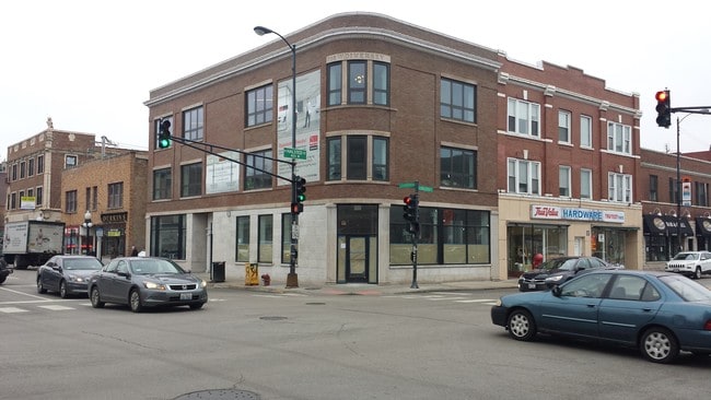
Property Record
2800 N Halsted St, Chicago, IL 60657


NEARBY LISTINGS FOR SALE OR LEASE
Property Detail
2800 N Halsted St
Chicago-Naperville-Elgin, IL-IN
Heaneys Sub
14-29-230-032-0000
MARY D (HEANEYS) SUB OF LTS6-10 OF BLK2 OF HENRY WOLF RAMS SUB OF OUTLOT 8 OF CANAL TRUSTEES SUB OF EH SEC 29-40-14
Storebuilding
Cook
X
Illinois
17031C0417K
6-10
2023
0.59 AC
2025
Lincoln Park
062100
Chicago
6,096 SF
DEMOGRAPHICS near 2800 N Halsted St
1 Mile
3 Mile
5 Mile
2024 Total Population
103,556
473,517
1,004,320
2029 Population
101,184
461,506
972,452
Pop Growth 2024-2029
(2.29%)
(2.54%)
(3.17%)
Average Age
35
37
37
2024 Total Households
56,443
251,499
492,987
HH Growth 2024-2029
(2.52%)
(2.64%)
(3.08%)
Median Household Inc
$99,817
$104,881
$92,707
Avg Household Size
1.80
1.80
2.00
2024 Avg HH Vehicles
1.00
1.00
1.00
Median Home Value
$584,553
$544,762
$459,235
Median Year Built
1963
1965
1962
Nearby Places
Map Layers
Map Styles
 Street
 Aerial
- Restaurants
- Banks
- Shops
- Fitness
- Groceries
PUBLIC TRANSPORTATION
TRANSIT/SUBWAY
Diversey Station (Brown Line - Chicago Transit Authority "L" Trains (The "L"), Purple Line - Chicago Transit Authority "L" Trains (The "L"))
DRIVE
WALK
Distance
Diversey Station (Brown Line - Chicago Transit Authority "L" Trains (The "L"), Purple Line - Chicago Transit Authority "L" Trains (The "L"))
1 min
4 min
0.2 mi
Wellington Station (Brown Line - Chicago Transit Authority "L" Trains (The "L"), Purple Line - Chicago Transit Authority "L" Trains (The "L"))
DRIVE
WALK
Distance
Wellington Station (Brown Line - Chicago Transit Authority "L" Trains (The "L"), Purple Line - Chicago Transit Authority "L" Trains (The "L"))
3 min
9 min
0.5 mi
Belmont Station (Brown, Purple, Red Lines) (Brown Line - Chicago Transit Authority "L" Trains (The "L"), Purple Line - Chicago Transit Authority "L" Trains (The "L"), Red Line - Chicago Transit Authority "L" Trains (The "L"))
DRIVE
WALK
Distance
Belmont Station (Brown, Purple, Red Lines) (Brown Line - Chicago Transit Authority "L" Trains (The "L"), Purple Line - Chicago Transit Authority "L" Trains (The "L"), Red Line - Chicago Transit Authority "L" Trains (The "L"))
4 min
14 min
0.7 mi
Fullerton Station (Brown Line - Chicago Transit Authority "L" Trains (The "L"), Purple Line - Chicago Transit Authority "L" Trains (The "L"), Red Line - Chicago Transit Authority "L" Trains (The "L"))
DRIVE
WALK
Distance
Fullerton Station (Brown Line - Chicago Transit Authority "L" Trains (The "L"), Purple Line - Chicago Transit Authority "L" Trains (The "L"), Red Line - Chicago Transit Authority "L" Trains (The "L"))
3 min
15 min
0.7 mi
COMMUTER RAIL
Clybourn Station (Union Pacific North Line - Northeast Illinois Regional Commuter Railroad (Metra), Union Pacific Northwest Line - Northeast Illinois Regional Commuter Railroad (Metra))
DRIVE
WALK
Distance
Clybourn Station (Union Pacific North Line - Northeast Illinois Regional Commuter Railroad (Metra), Union Pacific Northwest Line - Northeast Illinois Regional Commuter Railroad (Metra))
7 min
2.1 mi
Ravenswood Station (Union Pacific North Line - Northeast Illinois Regional Commuter Railroad (Metra))
DRIVE
WALK
Distance
Ravenswood Station (Union Pacific North Line - Northeast Illinois Regional Commuter Railroad (Metra))
12 min
3.2 mi
AIRPORT
Chicago Midway International
DRIVE
WALK
Distance
Chicago Midway International
30 min
15.1 mi
Chicago O'Hare International
DRIVE
WALK
Distance
Chicago O'Hare International
25 min
15.5 mi
SALE & LEASE HISTORY
LISTING DATE
SALE/LEASE

Sep 25, 2016
For Lease
Oct 23, 2023
For Lease
Jun 11, 2020
For Lease
Jul 26, 2017
For Lease
Feb 10, 2020
For Lease
Aug 30, 2017
For Lease
Nearby Properties
Address
Land Use
TOTAL SIZE
Lot Size
Zoning
Address
Land Use
TOTAL SIZE
Lot Size
Zoning
831,084 SF
2.05 AC
PD 316
Address
Land Use
TOTAL SIZE
Lot Size
Zoning
1,578,363 SF
2.62 AC
DX-12
Address
Land Use
TOTAL SIZE
Lot Size
Zoning
1,857,394 SF
3.13 AC
PD 447
Address
Land Use
TOTAL SIZE
Lot Size
Zoning
1.09 AC
B1-3
Address
Land Use
TOTAL SIZE
Lot Size
Zoning
491,382 SF
2.05 AC
PD 316
Address
Land Use
TOTAL SIZE
Lot Size
Zoning
433,026 SF
0.47 AC
DX-12
Address
Land Use
TOTAL SIZE
Lot Size
Zoning
229,725 SF
1.21 AC
DX-12,DX-1
Address
Land Use
TOTAL SIZE
Lot Size
Zoning
1,284,706 SF
4.40 AC
Address
Land Use
TOTAL SIZE
Lot Size
Zoning
403,219 SF
1.42 AC
DX-12,DX-1
Address
Land Use
TOTAL SIZE
Lot Size
Zoning
549,130 SF
1.45 AC
DX-12
Address
Land Use
TOTAL SIZE
Lot Size
Zoning
276,408 SF
0.40 AC
PD 428
Address
Land Use
TOTAL SIZE
Lot Size
Zoning
1.36 AC
DX-12
Address
Land Use
TOTAL SIZE
Lot Size
Zoning
1,412,950 SF
1.03 AC
DX-12
Address
Land Use
TOTAL SIZE
Lot Size
Zoning
380,668 SF
0.48 AC
PD 218
Address
Land Use
TOTAL SIZE
Lot Size
Zoning
391,168 SF
1.13 AC
PD 380
Address
Land Use
TOTAL SIZE
Lot Size
Zoning
0.34 AC
PD 967
Address
Land Use
TOTAL SIZE
Lot Size
Zoning
266,248 SF
Address
Land Use
TOTAL SIZE
Lot Size
Zoning
228,018 SF
8.72 AC
PD 958
Address
Land Use
TOTAL SIZE
Lot Size
Zoning
935,613 SF
1.79 AC
PD 237
Address
Land Use
TOTAL SIZE
Lot Size
Zoning
393,325 SF
Address
Land Use
TOTAL SIZE
Lot Size
Zoning
Address
Land Use
TOTAL SIZE
Lot Size
Zoning
222,240 SF
2.45 AC
PD 1439
Address
Land Use
TOTAL SIZE
Lot Size
Zoning
275,000 SF
3.26 AC
PD 106
Address
Land Use
TOTAL SIZE
Lot Size
Zoning
Address
Land Use
TOTAL SIZE
Lot Size
Zoning
500,000 SF
1.13 AC
PD 106
Address
Land Use
TOTAL SIZE
Lot Size
Zoning
Address
Land Use
TOTAL SIZE
Lot Size
Zoning
602,197 SF
Address
Land Use
TOTAL SIZE
Lot Size
Zoning
623,912 SF
Address
Land Use
TOTAL SIZE
Lot Size
Zoning
61,300 SF
0.30 AC
B3-5
Address
Land Use
TOTAL SIZE
Lot Size
Zoning
494,076 SF
0.37 AC
DX-12
The World's #1 Commercial Real Estate Marketplace
Connect with us
© 2026 CoStar Group
The information above has been obtained from sources believed reliable. While we do not doubt its accuracy we have not verified it and make no guarantee, warranty or representation about it. It is your responsibility to independently confirm its accuracy and completeness. Any projections, opinions, assumptions, or estimates used are for example only and do not represent the current or future performance of the property. The value of this transaction to you depends on tax and other factors which should be evaluated by your tax, financial, and legal advisors. You and your advisors should conduct a careful, independent investigation of the property to determine to your satisfaction the suitability of the property for your needs.