Property Record
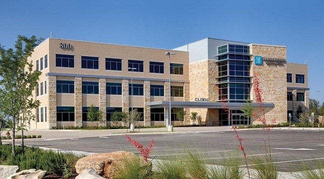
800 W Highway 71, Marble Falls, TX 78654
NEARBY LISTINGS FOR SALE OR LEASE
-
-
View all Marble Falls listings for lease on LoopNet.com
Property Detail
800 W Highway 71
Commercialnec
Scott & White Subdivision
X
S7521 SCOTT & WHITE SUBDIVISION LOT IMP ONLY ON 1A BLK 1
48053C0325G
Burnet
2024
Texas
2025
Central Texas Area
960801
Other Market Areas
67,050 SF
108371
DEMOGRAPHICS near 800 W Highway 71
1 Mile
3 Mile
5 Mile
2024 Total Population
121
1,812
12,987
2029 Population
145
2,141
15,248
Pop Growth 2024-2029
+ 19.83%
+ 18.16%
+ 17.41%
Average Age
42
42
46
2024 Total Households
45
721
5,618
HH Growth 2024-2029
+ 20.00%
+ 17.48%
+ 16.82%
Median Household Inc
$59,999
$69,749
$61,248
Avg Household Size
2.60
2.50
2.30
2024 Avg HH Vehicles
2.00
2.00
2.00
Median Home Value
$194,444
$325,757
$294,560
Median Year Built
1993
2000
1994
Nearby Places
Map Layers
Map Styles
 Street
 Aerial
- Restaurants
- Banks
- Shops
- Fitness
- Groceries
SALE & LEASE HISTORY
LISTING DATE
SALE/LEASE

Jul 12, 2018
For Lease
Nearby Properties
Address
Land Use
TOTAL SIZE
Lot Size
Zoning
Address
Land Use
TOTAL SIZE
Lot Size
Zoning
430,494 SF
20.19 AC
Address
Land Use
TOTAL SIZE
Lot Size
Zoning
180,558 SF
25.18 AC
Address
Land Use
TOTAL SIZE
Lot Size
Zoning
265,088 SF
13.23 AC
Address
Land Use
TOTAL SIZE
Lot Size
Zoning
152,379 SF
7.57 AC
Address
Land Use
TOTAL SIZE
Lot Size
Zoning
727.66 AC
Address
Land Use
TOTAL SIZE
Lot Size
Zoning
9,511 SF
77 AC
Address
Land Use
TOTAL SIZE
Lot Size
Zoning
211.16 AC
Address
Land Use
TOTAL SIZE
Lot Size
Zoning
1,620 SF
6.97 AC
Address
Land Use
TOTAL SIZE
Lot Size
Zoning
26.55 AC
Address
Land Use
TOTAL SIZE
Lot Size
Zoning
21.16 AC
Address
Land Use
TOTAL SIZE
Lot Size
Zoning
17,275 SF
10.30 AC
Address
Land Use
TOTAL SIZE
Lot Size
Zoning
10,748 SF
2.45 AC
Address
Land Use
TOTAL SIZE
Lot Size
Zoning
71,413 SF
5 AC
Address
Land Use
TOTAL SIZE
Lot Size
Zoning
Address
Land Use
TOTAL SIZE
Lot Size
Zoning
8,766 SF
293.41 AC
Address
Land Use
TOTAL SIZE
Lot Size
Zoning
10,236 SF
6.50 AC
Address
Land Use
TOTAL SIZE
Lot Size
Zoning
2,305 SF
4.60 AC
Address
Land Use
TOTAL SIZE
Lot Size
Zoning
558 SF
12.12 AC
Address
Land Use
TOTAL SIZE
Lot Size
Zoning
7,496 SF
7.67 AC
Address
Land Use
TOTAL SIZE
Lot Size
Zoning
134.62 AC
Address
Land Use
TOTAL SIZE
Lot Size
Zoning
2,494 SF
9.62 AC
Address
Land Use
TOTAL SIZE
Lot Size
Zoning
6,829 SF
10 AC
Address
Land Use
TOTAL SIZE
Lot Size
Zoning
4,609 SF
10.67 AC
Address
Land Use
TOTAL SIZE
Lot Size
Zoning
17,100 SF
1.62 AC
Address
Land Use
TOTAL SIZE
Lot Size
Zoning
9,500 SF
0.46 AC
Address
Land Use
TOTAL SIZE
Lot Size
Zoning
12,858 SF
0.93 AC
Address
Land Use
TOTAL SIZE
Lot Size
Zoning
6,687 SF
2.27 AC
Address
Land Use
TOTAL SIZE
Lot Size
Zoning
The World's #1 Commercial Real Estate Marketplace
Connect with us
© 2026 CoStar Group
The information above has been obtained from sources believed reliable. While we do not doubt its accuracy we have not verified it and make no guarantee, warranty or representation about it. It is your responsibility to independently confirm its accuracy and completeness. Any projections, opinions, assumptions, or estimates used are for example only and do not represent the current or future performance of the property. The value of this transaction to you depends on tax and other factors which should be evaluated by your tax, financial, and legal advisors. You and your advisors should conduct a careful, independent investigation of the property to determine to your satisfaction the suitability of the property for your needs.