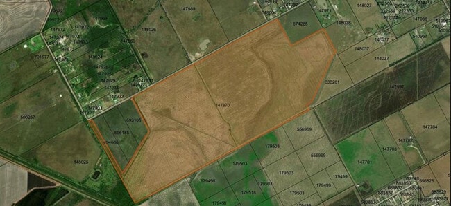
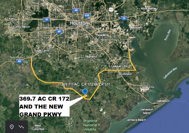
Property Record
172 County Road 172, Alvin, TX 77511

NEARBY LISTINGS FOR SALE OR LEASE
Property Detail
172 County Road 172
Houston-The Woodlands-Sugar Land, TX
S T Angier
0007-0014-000
A0007 S T ANGIER TRACT 8 ACRES 368.89
Agriculturalland
Brazoria
X
Texas
48039C0280K
368.89 AC
2024
South Hwy 35
2025
Houston
661400
DEMOGRAPHICS near 172 County Road 172
1 Mile
3 Mile
5 Mile
2024 Total Population
155
4,015
9,514
2029 Population
174
4,488
10,614
Pop Growth 2024-2029
+ 12.26%
+ 11.78%
+ 11.56%
Average Age
37
38
39
2024 Total Households
46
1,272
3,092
HH Growth 2024-2029
+ 13.04%
+ 11.87%
+ 11.74%
Median Household Inc
$78,571
$74,780
$82,287
Avg Household Size
3.10
3.00
2.90
2024 Avg HH Vehicles
3.00
2.00
3.00
Median Home Value
$342,857
$290,051
$299,062
Median Year Built
1994
1992
1991
Nearby Places
Map Layers
Map Styles
 Street
 Aerial
- Restaurants
- Banks
- Shops
- Fitness
- Groceries
PUBLIC TRANSPORTATION
AIRPORT
William P Hobby
DRIVE
WALK
Distance
William P Hobby
49 min
27.7 mi
Freight Ports
Port Freeport
DRIVE
WALK
Distance
Port Freeport
53 min
33.8 mi
SALE & LEASE HISTORY
LISTING DATE
SALE/LEASE

Sep 24, 2016
For Sale
Mar 21, 2023
For Sale
Mar 01, 2017
For Sale
Nearby Properties
Address
Land Use
TOTAL SIZE
Lot Size
Zoning
Address
Land Use
TOTAL SIZE
Lot Size
Zoning
9,979 SF
5.37 AC
Address
Land Use
TOTAL SIZE
Lot Size
Zoning
14,521 SF
54.99 AC
Address
Land Use
TOTAL SIZE
Lot Size
Zoning
10,640 SF
4.97 AC
Address
Land Use
TOTAL SIZE
Lot Size
Zoning
18,800 SF
12.96 AC
Address
Land Use
TOTAL SIZE
Lot Size
Zoning
26,960 SF
59.60 AC
0051
Address
Land Use
TOTAL SIZE
Lot Size
Zoning
18,236 SF
16.28 AC
0034
Address
Land Use
TOTAL SIZE
Lot Size
Zoning
28,274 SF
4.80 AC
Address
Land Use
TOTAL SIZE
Lot Size
Zoning
16,450 SF
10 AC
0023
Address
Land Use
TOTAL SIZE
Lot Size
Zoning
19.71 AC
0186
Address
Land Use
TOTAL SIZE
Lot Size
Zoning
7,500 SF
12.72 AC
0025
Address
Land Use
TOTAL SIZE
Lot Size
Zoning
512 SF
8.14 AC
0037
Address
Land Use
TOTAL SIZE
Lot Size
Zoning
9,269 SF
11.84 AC
Address
Land Use
TOTAL SIZE
Lot Size
Zoning
15.23 AC
0193
Address
Land Use
TOTAL SIZE
Lot Size
Zoning
10,293 SF
1.57 AC
Address
Land Use
TOTAL SIZE
Lot Size
Zoning
3,576 SF
1.64 AC
Address
Land Use
TOTAL SIZE
Lot Size
Zoning
74.35 AC
0220
Address
Land Use
TOTAL SIZE
Lot Size
Zoning
13.74 AC
0110
Address
Land Use
TOTAL SIZE
Lot Size
Zoning
6,280 SF
80 AC
0019
Address
Land Use
TOTAL SIZE
Lot Size
Zoning
53.30 AC
0050
Address
Land Use
TOTAL SIZE
Lot Size
Zoning
10.77 AC
Address
Land Use
TOTAL SIZE
Lot Size
Zoning
8,106 SF
89.54 AC
Address
Land Use
TOTAL SIZE
Lot Size
Zoning
6,136 SF
10.50 AC
Address
Land Use
TOTAL SIZE
Lot Size
Zoning
7,656 SF
51.10 AC
Address
Land Use
TOTAL SIZE
Lot Size
Zoning
2,927 SF
18.06 AC
0111
Address
Land Use
TOTAL SIZE
Lot Size
Zoning
3,758 SF
16 AC
Address
Land Use
TOTAL SIZE
Lot Size
Zoning
6,845 SF
10.50 AC
Address
Land Use
TOTAL SIZE
Lot Size
Zoning
7,803 SF
9.27 AC
Address
Land Use
TOTAL SIZE
Lot Size
Zoning
26.49 AC
0078
Address
Land Use
TOTAL SIZE
Lot Size
Zoning
4,535 SF
2 AC
0050
Address
Land Use
TOTAL SIZE
Lot Size
Zoning
7.49 AC
The World's #1 Commercial Real Estate Marketplace
Connect with us
© 2025 CoStar Group
The information above has been obtained from sources believed reliable. While we do not doubt its accuracy we have not verified it and make no guarantee, warranty or representation about it. It is your responsibility to independently confirm its accuracy and completeness. Any projections, opinions, assumptions, or estimates used are for example only and do not represent the current or future performance of the property. The value of this transaction to you depends on tax and other factors which should be evaluated by your tax, financial, and legal advisors. You and your advisors should conduct a careful, independent investigation of the property to determine to your satisfaction the suitability of the property for your needs.