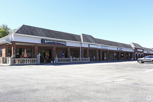
Property Record
8001-8053 Mayfield Rd, Chesterland, OH 44026

NEARBY LISTINGS FOR SALE OR LEASE
-
-
View all Chesterland listings for lease on LoopNet.com
Property Detail
8001-8053 Mayfield Rd
Cleveland-Elyria, OH
C&B Subdivision
11-385400
LOT 24 TR 3
Communitycenter
Geauga
X
Ohio
39055C0115D
24
2024
6.87 AC
2024
Geauga County
310600
Cleveland
61,694 SF
DEMOGRAPHICS near 8001-8053 Mayfield Rd
1 Mile
3 Mile
5 Mile
2024 Total Population
1,710
10,878
35,700
2029 Population
1,721
10,902
35,443
Pop Growth 2024-2029
+ 0.64%
+ 0.22%
(0.72%)
Average Age
45
46
46
2024 Total Households
688
4,345
15,747
HH Growth 2024-2029
+ 0.58%
+ 0.09%
(0.95%)
Median Household Inc
$89,583
$94,511
$82,210
Avg Household Size
2.50
2.50
2.20
2024 Avg HH Vehicles
2.00
2.00
2.00
Median Home Value
$240,616
$271,294
$285,275
Median Year Built
1960
1965
1967
Nearby Places
Map Layers
Map Styles
 Street
 Aerial
- Restaurants
- Banks
- Shops
- Fitness
- Groceries
PUBLIC TRANSPORTATION
AIRPORT
Cleveland-Hopkins International
DRIVE
WALK
Distance
Cleveland-Hopkins International
48 min
32.4 mi
Freight Ports
Port of Toledo
DRIVE
WALK
Distance
Port of Toledo
162 min
133.4 mi
SALE & LEASE HISTORY
LISTING DATE
SALE/LEASE

Sep 24, 2016
For Lease
Mar 19, 2024
For Lease
Jan 30, 2019
For Lease
Nearby Properties
Address
Land Use
TOTAL SIZE
Lot Size
Zoning
Address
Land Use
TOTAL SIZE
Lot Size
Zoning
1,285 SF
298.69 AC
R5A
Address
Land Use
TOTAL SIZE
Lot Size
Zoning
165,544 SF
15 AC
R
Address
Land Use
TOTAL SIZE
Lot Size
Zoning
114,017 SF
30 AC
R
Address
Land Use
TOTAL SIZE
Lot Size
Zoning
3,164 SF
34.07 AC
R3A
Address
Land Use
TOTAL SIZE
Lot Size
Zoning
16,439 SF
72.27 AC
R5
Address
Land Use
TOTAL SIZE
Lot Size
Zoning
2,250 SF
20.28 AC
R
Address
Land Use
TOTAL SIZE
Lot Size
Zoning
36,258 SF
30.56 AC
U-1
Address
Land Use
TOTAL SIZE
Lot Size
Zoning
12,023 SF
5.07 AC
U-1
Address
Land Use
TOTAL SIZE
Lot Size
Zoning
34,716 SF
15.63 AC
U-1
Address
Land Use
TOTAL SIZE
Lot Size
Zoning
103,320 SF
13.67 AC
C
Address
Land Use
TOTAL SIZE
Lot Size
Zoning
40,566 SF
7.74 AC
SC
Address
Land Use
TOTAL SIZE
Lot Size
Zoning
52,994 SF
15 AC
R3A
Address
Land Use
TOTAL SIZE
Lot Size
Zoning
48,438 SF
14 AC
R3A
Address
Land Use
TOTAL SIZE
Lot Size
Zoning
36,021 SF
27.36 AC
U-1
Address
Land Use
TOTAL SIZE
Lot Size
Zoning
17,650 SF
6.70 AC
C
Address
Land Use
TOTAL SIZE
Lot Size
Zoning
60,714 SF
14.53 AC
R5
Address
Land Use
TOTAL SIZE
Lot Size
Zoning
8,241 SF
24.16 AC
R5
Address
Land Use
TOTAL SIZE
Lot Size
Zoning
9,851 SF
8.23 AC
Address
Land Use
TOTAL SIZE
Lot Size
Zoning
2,875 SF
36.15 AC
R3A
Address
Land Use
TOTAL SIZE
Lot Size
Zoning
37.16 AC
U-1
Address
Land Use
TOTAL SIZE
Lot Size
Zoning
28,711 SF
10.56 AC
U-2
Address
Land Use
TOTAL SIZE
Lot Size
Zoning
50,362 SF
6 AC
C
Address
Land Use
TOTAL SIZE
Lot Size
Zoning
5,172 SF
2.50 AC
U-1
Address
Land Use
TOTAL SIZE
Lot Size
Zoning
20,114 SF
4.50 AC
R
Address
Land Use
TOTAL SIZE
Lot Size
Zoning
53.06 AC
U-1
Address
Land Use
TOTAL SIZE
Lot Size
Zoning
16,113 SF
11.62 AC
U-1
Address
Land Use
TOTAL SIZE
Lot Size
Zoning
23,342 SF
9.40 AC
U-1
Address
Land Use
TOTAL SIZE
Lot Size
Zoning
17,115 SF
8.85 AC
Address
Land Use
TOTAL SIZE
Lot Size
Zoning
15,600 SF
8.75 AC
I
The World's #1 Commercial Real Estate Marketplace
Connect with us
© 2026 CoStar Group
The information above has been obtained from sources believed reliable. While we do not doubt its accuracy we have not verified it and make no guarantee, warranty or representation about it. It is your responsibility to independently confirm its accuracy and completeness. Any projections, opinions, assumptions, or estimates used are for example only and do not represent the current or future performance of the property. The value of this transaction to you depends on tax and other factors which should be evaluated by your tax, financial, and legal advisors. You and your advisors should conduct a careful, independent investigation of the property to determine to your satisfaction the suitability of the property for your needs.