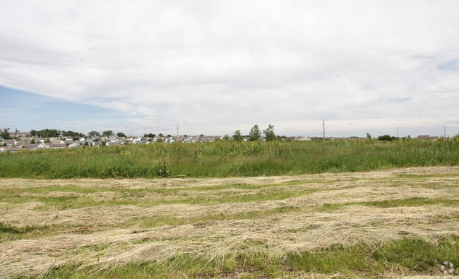
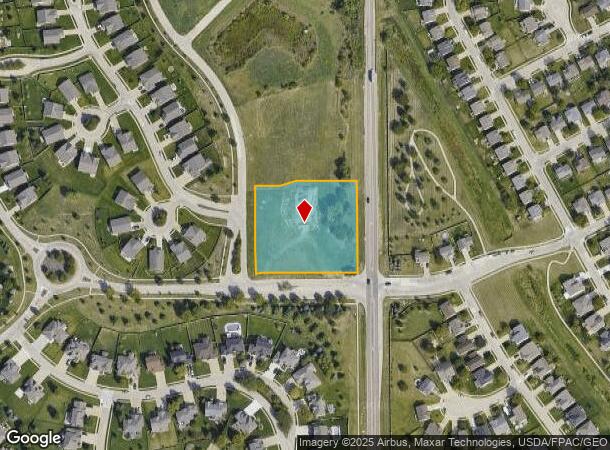
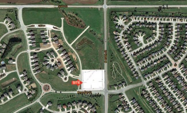
Property Record
8001 N 157Th St, Bennington, NE 68007
NEARBY LISTINGS FOR SALE OR LEASE
Property Detail
8001 N 157Th St
Omaha-Council Bluffs, NE-IA
Pine Creek
1214-7150-20
PINE CREEK REP 2* LOT 1 BLOCK 0 IRREG 1.831 AC
Regionalshoppingcenterormallwithanchorstore
Douglas
X
Nebraska
31055C0183J
1
2024
1.83 AC
2025
Northwest Omaha
007318
Omaha/Council Bluffs
15,244 SF
DEMOGRAPHICS near 8001 N 157Th St
1 Mile
3 Mile
5 Mile
2024 Total Population
10,999
49,396
117,129
2029 Population
11,511
50,817
119,438
Pop Growth 2024-2029
+ 4.65%
+ 2.88%
+ 1.97%
Average Age
33
37
38
2024 Total Households
3,471
17,816
43,856
HH Growth 2024-2029
+ 4.58%
+ 2.68%
+ 1.88%
Median Household Inc
$122,479
$112,799
$101,641
Avg Household Size
3.10
2.70
2.60
2024 Avg HH Vehicles
2.00
2.00
2.00
Median Home Value
$324,806
$299,155
$281,259
Median Year Built
2010
2006
1999
Nearby Places
Map Layers
Map Styles
 Street
 Aerial
- Restaurants
- Banks
- Shops
- Fitness
- Groceries
PUBLIC TRANSPORTATION
AIRPORT
Eppley Airfield
DRIVE
WALK
Distance
Eppley Airfield
33 min
17.2 mi
SALE & LEASE HISTORY
LISTING DATE
SALE/LEASE

May 04, 2017
For Sale
Apr 06, 2022
For Sale
Nearby Properties
Address
Land Use
TOTAL SIZE
Lot Size
Zoning
Address
Land Use
TOTAL SIZE
Lot Size
Zoning
396,428 SF
14.45 AC
R6
Address
Land Use
TOTAL SIZE
Lot Size
Zoning
311,856 SF
19.22 AC
Address
Land Use
TOTAL SIZE
Lot Size
Zoning
339,557 SF
12.89 AC
R7
Address
Land Use
TOTAL SIZE
Lot Size
Zoning
350,925 SF
12.71 AC
Address
Land Use
TOTAL SIZE
Lot Size
Zoning
320,111 SF
19.17 AC
R4
Address
Land Use
TOTAL SIZE
Lot Size
Zoning
301,689 SF
8.82 AC
Address
Land Use
TOTAL SIZE
Lot Size
Zoning
261,247 SF
13.20 AC
Address
Land Use
TOTAL SIZE
Lot Size
Zoning
228,963 SF
7.36 AC
Address
Land Use
TOTAL SIZE
Lot Size
Zoning
149,081 SF
9.01 AC
Address
Land Use
TOTAL SIZE
Lot Size
Zoning
69,358 SF
10.22 AC
Address
Land Use
TOTAL SIZE
Lot Size
Zoning
189,099 SF
7.13 AC
Address
Land Use
TOTAL SIZE
Lot Size
Zoning
166,080 SF
6.25 AC
R6
Address
Land Use
TOTAL SIZE
Lot Size
Zoning
207,693 SF
21.62 AC
MU
Address
Land Use
TOTAL SIZE
Lot Size
Zoning
173,593 SF
5.70 AC
R6PUD
Address
Land Use
TOTAL SIZE
Lot Size
Zoning
169,654 SF
8.02 AC
Address
Land Use
TOTAL SIZE
Lot Size
Zoning
99,983 SF
9.37 AC
Address
Land Use
TOTAL SIZE
Lot Size
Zoning
137,022 SF
5.83 AC
R6
Address
Land Use
TOTAL SIZE
Lot Size
Zoning
126,496 SF
2.96 AC
MU
Address
Land Use
TOTAL SIZE
Lot Size
Zoning
121,376 SF
4.21 AC
Address
Land Use
TOTAL SIZE
Lot Size
Zoning
71,584 SF
11.72 AC
CC
Address
Land Use
TOTAL SIZE
Lot Size
Zoning
116,097 SF
12.93 AC
MU
Address
Land Use
TOTAL SIZE
Lot Size
Zoning
86,803 SF
20.98 AC
Address
Land Use
TOTAL SIZE
Lot Size
Zoning
95,756 SF
2.96 AC
Address
Land Use
TOTAL SIZE
Lot Size
Zoning
71,016 SF
3.77 AC
Address
Land Use
TOTAL SIZE
Lot Size
Zoning
106,465 SF
11.11 AC
Address
Land Use
TOTAL SIZE
Lot Size
Zoning
80,791 SF
3.92 AC
R6
Address
Land Use
TOTAL SIZE
Lot Size
Zoning
37,829 SF
3.80 AC
MU
Address
Land Use
TOTAL SIZE
Lot Size
Zoning
79,669 SF
4.75 AC
MU
Address
Land Use
TOTAL SIZE
Lot Size
Zoning
44,516 SF
5.40 AC
MU
Address
Land Use
TOTAL SIZE
Lot Size
Zoning
31,397 SF
3.42 AC
The World's #1 Commercial Real Estate Marketplace
Connect with us
© 2025 CoStar Group
The information above has been obtained from sources believed reliable. While we do not doubt its accuracy we have not verified it and make no guarantee, warranty or representation about it. It is your responsibility to independently confirm its accuracy and completeness. Any projections, opinions, assumptions, or estimates used are for example only and do not represent the current or future performance of the property. The value of this transaction to you depends on tax and other factors which should be evaluated by your tax, financial, and legal advisors. You and your advisors should conduct a careful, independent investigation of the property to determine to your satisfaction the suitability of the property for your needs.