Property Record
8001 W Jefferson Ave, Detroit, MI 48209

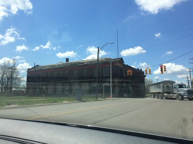
This Property Is For Sale
NEARBY LISTINGS FOR SALE OR LEASE
Property Detail
8001 W Jefferson Ave
20-000031
Delray
Commercialnec
S JEFFERSON 48 E 1/2 47 DELRAY SUB L1 P80 PLATS, W C R 20/1 75 X 120
X
Wayne
26163C0286F
Michigan
2025
0.21 AC
2025
Detroit West
523800
Detroit
17,926 SF
Detroit-Warren-Dearborn, MI
DEMOGRAPHICS near 8001 W Jefferson Ave
1 Mile
3 Mile
5 Mile
2024 Total Population
3,154
58,523
210,210
2029 Population
3,109
57,111
205,664
Pop Growth 2024-2029
(1.43%)
(2.41%)
(2.16%)
Average Age
33
34
36
2024 Total Households
997
19,510
78,052
HH Growth 2024-2029
(1.40%)
(2.33%)
(1.84%)
Median Household Inc
$34,648
$35,492
$39,867
Avg Household Size
3.00
2.80
2.60
2024 Avg HH Vehicles
1.00
1.00
1.00
Median Home Value
$123,809
$74,432
$101,990
Median Year Built
1946
1947
1949
Nearby Places
Map Layers
Map Styles
 Street
 Aerial
- Restaurants
- Banks
- Shops
- Fitness
- Groceries
PUBLIC TRANSPORTATION
COMMUTER RAIL
DRIVE
WALK
Distance
14 min
7.5 mi
DRIVE
WALK
Distance
18 min
8.6 mi
AIRPORT
Windsor International
DRIVE
WALK
Distance
Windsor International
30 min
14.4 mi
Detroit Metro Wayne County
DRIVE
WALK
Distance
Detroit Metro Wayne County
31 min
18.1 mi
Freight Ports
DRIVE
WALK
Distance
69 min
55.7 mi
Nearby Properties
Address
Land Use
TOTAL SIZE
Lot Size
Zoning
Address
Land Use
TOTAL SIZE
Lot Size
Zoning
409,438 SF
0.83 AC
B6
Address
Land Use
TOTAL SIZE
Lot Size
Zoning
6,620 SF
9.43 AC
B6
Address
Land Use
TOTAL SIZE
Lot Size
Zoning
590,116 SF
388.80 AC
ID
Address
Land Use
TOTAL SIZE
Lot Size
Zoning
7,320 SF
226.49 AC
Address
Land Use
TOTAL SIZE
Lot Size
Zoning
309,661 SF
8.81 AC
M4
Address
Land Use
TOTAL SIZE
Lot Size
Zoning
342,272 SF
16.48 AC
M4
Address
Land Use
TOTAL SIZE
Lot Size
Zoning
303,705 SF
17.28 AC
ID
Address
Land Use
TOTAL SIZE
Lot Size
Zoning
381,532 SF
M4
Address
Land Use
TOTAL SIZE
Lot Size
Zoning
196,801 SF
38.32 AC
M5
Address
Land Use
TOTAL SIZE
Lot Size
Zoning
47,524 SF
Address
Land Use
TOTAL SIZE
Lot Size
Zoning
145,572 SF
58.41 AC
M4
Address
Land Use
TOTAL SIZE
Lot Size
Zoning
314,003 SF
26.32 AC
B6
Address
Land Use
TOTAL SIZE
Lot Size
Zoning
79.03 AC
M2 HEAV
Address
Land Use
TOTAL SIZE
Lot Size
Zoning
193,114 SF
20.29 AC
M4
Address
Land Use
TOTAL SIZE
Lot Size
Zoning
290,849 SF
13.21 AC
IC
Address
Land Use
TOTAL SIZE
Lot Size
Zoning
52,964 SF
10.89 AC
Address
Land Use
TOTAL SIZE
Lot Size
Zoning
351,906 SF
42.21 AC
M4
Address
Land Use
TOTAL SIZE
Lot Size
Zoning
418,631 SF
13.88 AC
ID
Address
Land Use
TOTAL SIZE
Lot Size
Zoning
183,311 SF
15.99 AC
M4
Address
Land Use
TOTAL SIZE
Lot Size
Zoning
897,317 SF
34.53 AC
ID
Address
Land Use
TOTAL SIZE
Lot Size
Zoning
383,352 SF
8.23 AC
M4
Address
Land Use
TOTAL SIZE
Lot Size
Zoning
90,005 SF
611 AC
BLL
Address
Land Use
TOTAL SIZE
Lot Size
Zoning
660 SF
41.97 AC
R1 1 FA
Address
Land Use
TOTAL SIZE
Lot Size
Zoning
45,400 SF
R1 1 FA
Address
Land Use
TOTAL SIZE
Lot Size
Zoning
32,245 SF
23.27 AC
M5
Address
Land Use
TOTAL SIZE
Lot Size
Zoning
95,679 SF
27.44 AC
M4
Address
Land Use
TOTAL SIZE
Lot Size
Zoning
57,128 SF
2.46 AC
PD
Address
Land Use
TOTAL SIZE
Lot Size
Zoning
145,490 SF
12.61 AC
M4
Address
Land Use
TOTAL SIZE
Lot Size
Zoning
192,190 SF
20.83 AC
M4
Address
Land Use
TOTAL SIZE
Lot Size
Zoning
106.97 AC
M2 HEAV
The World's #1 Commercial Real Estate Marketplace
Connect with us
© 2026 CoStar Group
The information above has been obtained from sources believed reliable. While we do not doubt its accuracy we have not verified it and make no guarantee, warranty or representation about it. It is your responsibility to independently confirm its accuracy and completeness. Any projections, opinions, assumptions, or estimates used are for example only and do not represent the current or future performance of the property. The value of this transaction to you depends on tax and other factors which should be evaluated by your tax, financial, and legal advisors. You and your advisors should conduct a careful, independent investigation of the property to determine to your satisfaction the suitability of the property for your needs.