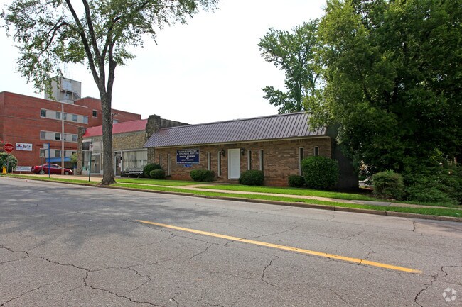
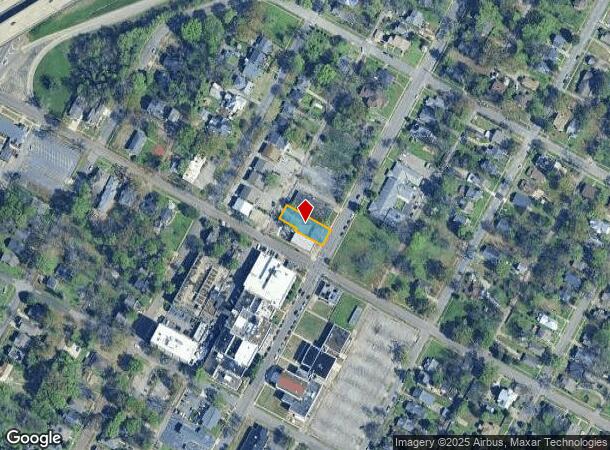
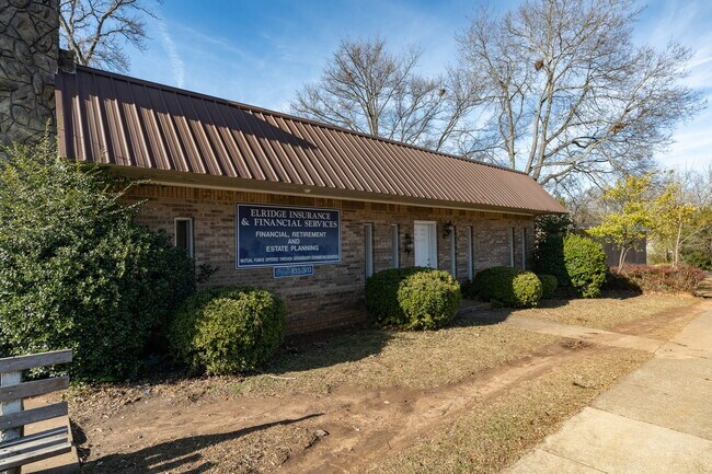
Property Record
8004 2Nd Ave S, Birmingham, AL 35206
NEARBY LISTINGS FOR SALE OR LEASE
Property Detail
8004 2Nd Ave S
Birmingham-Hoover, AL
Beck R W Survey 23-11-3
23-00-11-3-017-008.000
LOT 2 & S 100 FT OF E 10 FT OF LOT 1 BLK 123 R W BECK SUR
Financialbuilding
Jefferson
X
Alabama
01073C0403H
2,1
2023
0.24 AC
2024
Center Point
002100
Birmingham
1,248 SF
DEMOGRAPHICS near 8004 2Nd Ave S
1 Mile
3 Mile
5 Mile
2024 Total Population
11,296
43,878
108,838
2029 Population
11,459
43,833
107,612
Pop Growth 2024-2029
+ 1.44%
(0.10%)
(1.13%)
Average Age
39
39
39
2024 Total Households
4,272
17,693
44,152
HH Growth 2024-2029
+ 1.31%
(0.29%)
(1.24%)
Median Household Inc
$27,542
$41,012
$50,012
Avg Household Size
2.40
2.30
2.30
2024 Avg HH Vehicles
1.00
2.00
2.00
Median Home Value
$72,495
$137,538
$172,761
Median Year Built
1956
1962
1967
Nearby Places
Map Layers
Map Styles
 Street
 Aerial
- Restaurants
- Banks
- Shops
- Fitness
- Groceries
PUBLIC TRANSPORTATION
COMMUTER RAIL
Birmingham (Crescent - Amtrak)
DRIVE
WALK
Distance
Birmingham (Crescent - Amtrak)
10 min
6.3 mi
AIRPORT
Birmingham-Shuttlesworth International
DRIVE
WALK
Distance
Birmingham-Shuttlesworth International
6 min
3.4 mi
Freight Ports
Port of Mobile
DRIVE
WALK
Distance
Port of Mobile
289 min
262.6 mi
SALE & LEASE HISTORY
LISTING DATE
SALE/LEASE

Feb 12, 2025
For Sale
Nearby Properties
Address
Land Use
TOTAL SIZE
Lot Size
Zoning
Address
Land Use
TOTAL SIZE
Lot Size
Zoning
145,865 SF
142 AC
M1-M
Address
Land Use
TOTAL SIZE
Lot Size
Zoning
298,966 SF
73 AC
M1
Address
Land Use
TOTAL SIZE
Lot Size
Zoning
166,863 SF
21 AC
CB2
Address
Land Use
TOTAL SIZE
Lot Size
Zoning
80,288 SF
2.91 AC
CB2
Address
Land Use
TOTAL SIZE
Lot Size
Zoning
144,135 SF
31.95 AC
CR5
Address
Land Use
TOTAL SIZE
Lot Size
Zoning
297,391 SF
27.10 AC
CR5
Address
Land Use
TOTAL SIZE
Lot Size
Zoning
345,035 SF
39 AC
M1
Address
Land Use
TOTAL SIZE
Lot Size
Zoning
131,319 SF
13.28 AC
CB2
Address
Land Use
TOTAL SIZE
Lot Size
Zoning
456,619 SF
27.30 AC
M2
Address
Land Use
TOTAL SIZE
Lot Size
Zoning
22 AC
CB2
Address
Land Use
TOTAL SIZE
Lot Size
Zoning
210,920 SF
22.41 AC
CB2
Address
Land Use
TOTAL SIZE
Lot Size
Zoning
145,949 SF
10.01 AC
QR6
Address
Land Use
TOTAL SIZE
Lot Size
Zoning
112,806 SF
2.04 AC
R2
Address
Land Use
TOTAL SIZE
Lot Size
Zoning
222,082 SF
46 AC
R3
Address
Land Use
TOTAL SIZE
Lot Size
Zoning
166,144 SF
12.95 AC
CB2
Address
Land Use
TOTAL SIZE
Lot Size
Zoning
102,748 SF
8.50 AC
CB2
Address
Land Use
TOTAL SIZE
Lot Size
Zoning
113,147 SF
115 AC
M1
Address
Land Use
TOTAL SIZE
Lot Size
Zoning
178,988 SF
8.29 AC
CR5
Address
Land Use
TOTAL SIZE
Lot Size
Zoning
205,872 SF
12.53 AC
CB2
Address
Land Use
TOTAL SIZE
Lot Size
Zoning
8.10 AC
QR6
Address
Land Use
TOTAL SIZE
Lot Size
Zoning
223,365 SF
15 AC
I1
Address
Land Use
TOTAL SIZE
Lot Size
Zoning
108,813 SF
156 AC
M-1
Address
Land Use
TOTAL SIZE
Lot Size
Zoning
29,095 SF
2.64 AC
B2
Address
Land Use
TOTAL SIZE
Lot Size
Zoning
150,750 SF
12.60 AC
CR5
Address
Land Use
TOTAL SIZE
Lot Size
Zoning
301,531 SF
41 AC
B5
Address
Land Use
TOTAL SIZE
Lot Size
Zoning
188,160 SF
14 AC
CB2
Address
Land Use
TOTAL SIZE
Lot Size
Zoning
60,832 SF
162 AC
M1
Address
Land Use
TOTAL SIZE
Lot Size
Zoning
148,165 SF
15.65 AC
M1
Address
Land Use
TOTAL SIZE
Lot Size
Zoning
104,000 SF
7.66 AC
I1
Address
Land Use
TOTAL SIZE
Lot Size
Zoning
115,490 SF
3.88 AC
R2
The World's #1 Commercial Real Estate Marketplace
Connect with us
© 2025 CoStar Group
The information above has been obtained from sources believed reliable. While we do not doubt its accuracy we have not verified it and make no guarantee, warranty or representation about it. It is your responsibility to independently confirm its accuracy and completeness. Any projections, opinions, assumptions, or estimates used are for example only and do not represent the current or future performance of the property. The value of this transaction to you depends on tax and other factors which should be evaluated by your tax, financial, and legal advisors. You and your advisors should conduct a careful, independent investigation of the property to determine to your satisfaction the suitability of the property for your needs.