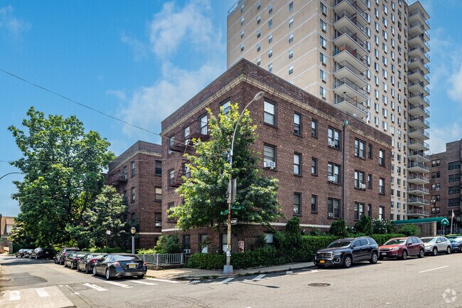
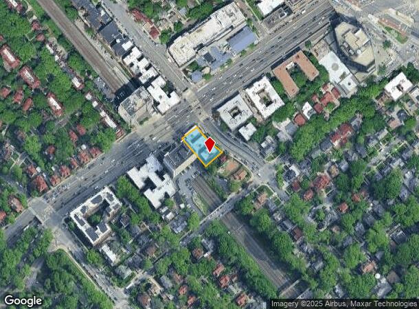
Property Record
8004 Austin St, Kew Gardens, NY 11415
NEARBY LISTINGS FOR SALE OR LEASE
Property Detail
8004 Austin St
03335-0030
Queens
Multifamilydwelling
New York
X
30
3604970229F
0.31 AC
2024
Kew Gardens
2025
Long Island (New York)
077300
New York-Jersey City-White Plains, NY-NJ
35,790 SF
DEMOGRAPHICS near 8004 Austin St
1 Mile
3 Mile
5 Mile
2024 Total Population
85,757
795,230
1,934,643
2029 Population
82,135
740,309
1,798,541
Pop Growth 2024-2029
(4.22%)
(6.91%)
(7.03%)
Average Age
43
41
41
2024 Total Households
36,357
268,847
654,944
HH Growth 2024-2029
(4.35%)
(6.93%)
(7.22%)
Median Household Inc
$88,804
$72,482
$67,886
Avg Household Size
2.30
2.80
2.80
2024 Avg HH Vehicles
1.00
1.00
1.00
Median Home Value
$575,376
$672,876
$670,864
Median Year Built
1950
1952
1952
Nearby Places
- Restaurants
- Banks
- Shops
- Fitness
- Groceries
PUBLIC TRANSPORTATION
TRANSIT/SUBWAY
Kew Gardens-Union Turnpike (E - New York MTA Subway (The Subway), F - New York MTA Subway (The Subway))
DRIVE
WALK
Distance
Kew Gardens-Union Turnpike (E - New York MTA Subway (The Subway), F - New York MTA Subway (The Subway))
3 min
4 min
0.2 mi
75 Avenue (E - New York MTA Subway (The Subway), F - New York MTA Subway (The Subway))
DRIVE
WALK
Distance
75 Avenue (E - New York MTA Subway (The Subway), F - New York MTA Subway (The Subway))
4 min
10 min
0.5 mi
Briarwood-Van Wyck Boulevard (E - New York MTA Subway (The Subway), F - New York MTA Subway (The Subway))
DRIVE
WALK
Distance
Briarwood-Van Wyck Boulevard (E - New York MTA Subway (The Subway), F - New York MTA Subway (The Subway))
2 min
15 min
0.8 mi
Forest Hills-71 Avenue (E - New York MTA Subway (The Subway), F - New York MTA Subway (The Subway), M - New York MTA Subway (The Subway), R - New York MTA Subway (The Subway))
DRIVE
WALK
Distance
Forest Hills-71 Avenue (E - New York MTA Subway (The Subway), F - New York MTA Subway (The Subway), M - New York MTA Subway (The Subway), R - New York MTA Subway (The Subway))
5 min
17 min
0.9 mi
121 Street (J - New York MTA Subway (The Subway), Z - New York MTA Subway (The Subway))
DRIVE
WALK
Distance
121 Street (J - New York MTA Subway (The Subway), Z - New York MTA Subway (The Subway))
3 min
19 min
1.0 mi
COMMUTER RAIL
Kew Gardens Station (Babylon Branch - Long Island Rail Road, Hempstead Branch - Long Island Rail Road, Long Beach Branch - Long Island Rail Road, Port Jefferson Branch - Long Island Rail Road)
DRIVE
WALK
Distance
Kew Gardens Station (Babylon Branch - Long Island Rail Road, Hempstead Branch - Long Island Rail Road, Long Beach Branch - Long Island Rail Road, Port Jefferson Branch - Long Island Rail Road)
1 min
7 min
0.3 mi
Forest Hills Station (Babylon Branch - Long Island Rail Road, Hempstead Branch - Long Island Rail Road, Long Beach Branch - Long Island Rail Road, Port Jefferson Branch - Long Island Rail Road)
DRIVE
WALK
Distance
Forest Hills Station (Babylon Branch - Long Island Rail Road, Hempstead Branch - Long Island Rail Road, Long Beach Branch - Long Island Rail Road, Port Jefferson Branch - Long Island Rail Road)
4 min
16 min
0.8 mi
AIRPORT
LaGuardia
DRIVE
WALK
Distance
LaGuardia
13 min
6.8 mi
John F Kennedy International
DRIVE
WALK
Distance
John F Kennedy International
11 min
7.1 mi
Newark Liberty International
DRIVE
WALK
Distance
Newark Liberty International
39 min
25.9 mi
Freight Ports
NY - Red Hook Container Terminal
DRIVE
WALK
Distance
NY - Red Hook Container Terminal
23 min
11.1 mi
Nearby Properties
Address
Land Use
TOTAL SIZE
Lot Size
Zoning
Address
Land Use
TOTAL SIZE
Lot Size
Zoning
4,528,000 SF
94.27 AC
R4
Address
Land Use
TOTAL SIZE
Lot Size
Zoning
2,078,606 SF
58.93 AC
R4
Address
Land Use
TOTAL SIZE
Lot Size
Zoning
1,258,350 SF
410.24 AC
PARK
Address
Land Use
TOTAL SIZE
Lot Size
Zoning
1,845,252 SF
172 AC
C8-1
Address
Land Use
TOTAL SIZE
Lot Size
Zoning
1,069,367 SF
14.65 AC
R4
Address
Land Use
TOTAL SIZE
Lot Size
Zoning
772,163 SF
5.24 AC
C4-5X
Address
Land Use
TOTAL SIZE
Lot Size
Zoning
54,170 SF
229.57 AC
PARK
Address
Land Use
TOTAL SIZE
Lot Size
Zoning
1,292,074 SF
C4-2F
Address
Land Use
TOTAL SIZE
Lot Size
Zoning
234,891 SF
3.17 AC
C4-5X
Address
Land Use
TOTAL SIZE
Lot Size
Zoning
1,516,458 SF
5.97 AC
R7-1
Address
Land Use
TOTAL SIZE
Lot Size
Zoning
532,011 SF
2.48 AC
R6
Address
Land Use
TOTAL SIZE
Lot Size
Zoning
15,000 SF
255.27 AC
PARK
Address
Land Use
TOTAL SIZE
Lot Size
Zoning
126.85 AC
PARK
Address
Land Use
TOTAL SIZE
Lot Size
Zoning
4,800 SF
80.10 AC
PARK
Address
Land Use
TOTAL SIZE
Lot Size
Zoning
1,000 SF
210.07 AC
R3-2
Address
Land Use
TOTAL SIZE
Lot Size
Zoning
1,572,198 SF
22.06 AC
M1-2
Address
Land Use
TOTAL SIZE
Lot Size
Zoning
738,000 SF
1.92 AC
C6-3
Address
Land Use
TOTAL SIZE
Lot Size
Zoning
344,116 SF
0.92 AC
R7-1
Address
Land Use
TOTAL SIZE
Lot Size
Zoning
577,654 SF
5.38 AC
R6
Address
Land Use
TOTAL SIZE
Lot Size
Zoning
291,589 SF
1.55 AC
C6-3
Address
Land Use
TOTAL SIZE
Lot Size
Zoning
2,193 SF
94.72 AC
PARK
Address
Land Use
TOTAL SIZE
Lot Size
Zoning
521,944 SF
16.68 AC
R4
Address
Land Use
TOTAL SIZE
Lot Size
Zoning
360,000 SF
5.88 AC
C4-2
Address
Land Use
TOTAL SIZE
Lot Size
Zoning
307,038 SF
7.84 AC
M1-1
Address
Land Use
TOTAL SIZE
Lot Size
Zoning
234,452 SF
2.99 AC
R4
Address
Land Use
TOTAL SIZE
Lot Size
Zoning
490,600 SF
12.01 AC
M1-1
Address
Land Use
TOTAL SIZE
Lot Size
Zoning
320,535 SF
1.52 AC
C4-4A
Address
Land Use
TOTAL SIZE
Lot Size
Zoning
248,200 SF
1.25 AC
R6
Address
Land Use
TOTAL SIZE
Lot Size
Zoning
377,896 SF
11.36 AC
R3-2
Address
Land Use
TOTAL SIZE
Lot Size
Zoning
384,249 SF
5.56 AC
R5
The World's #1 Commercial Real Estate Marketplace
Connect with us
© 2025 CoStar Group
The information above has been obtained from sources believed reliable. While we do not doubt its accuracy we have not verified it and make no guarantee, warranty or representation about it. It is your responsibility to independently confirm its accuracy and completeness. Any projections, opinions, assumptions, or estimates used are for example only and do not represent the current or future performance of the property. The value of this transaction to you depends on tax and other factors which should be evaluated by your tax, financial, and legal advisors. You and your advisors should conduct a careful, independent investigation of the property to determine to your satisfaction the suitability of the property for your needs.