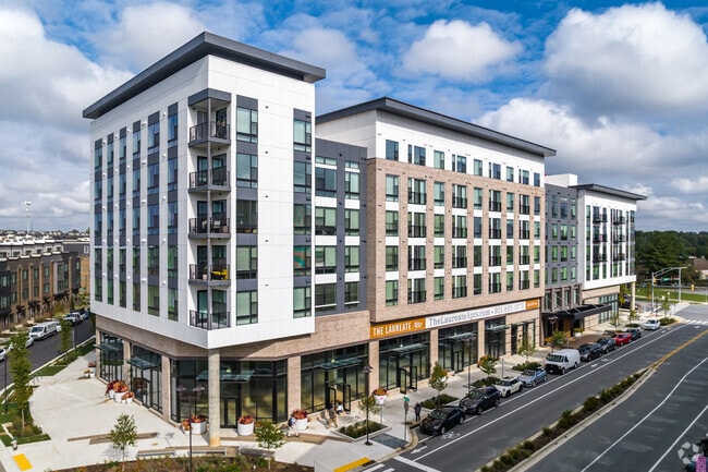
Property Record
Crabbs Branch Way, Rockville, MD 20855

Current Lease Availabilities
NEARBY LISTINGS FOR SALE OR LEASE
-
-
View all Rockville listings for lease on LoopNet.com
Property Detail
Crabbs Branch Way
09-03835827
TWO BROTHERS
Taxexempt
Montgomery
X
Maryland
24031C0193D
2.60 AC
0
Redland
2024
Washington, DC
701212
Washington-Arlington-Alexandria, DC-VA-MD-WV
DEMOGRAPHICS near Crabbs Branch Way
1 Mile
3 Mile
5 Mile
2024 Total Population
15,241
115,791
289,440
2029 Population
15,173
114,950
286,234
Pop Growth 2024-2029
(0.45%)
(0.73%)
(1.11%)
Average Age
41
39
40
2024 Total Households
6,217
44,121
104,407
HH Growth 2024-2029
(0.68%)
(0.71%)
(1.17%)
Median Household Inc
$115,484
$99,933
$112,363
Avg Household Size
2.40
2.50
2.70
2024 Avg HH Vehicles
2.00
2.00
2.00
Median Home Value
$637,562
$513,081
$563,445
Median Year Built
1996
1988
1984
Nearby Places
Map Layers
Map Styles
 Street
 Aerial
- Restaurants
- Banks
- Shops
- Fitness
- Groceries
PUBLIC TRANSPORTATION
COMMUTER RAIL
Washington Grove (BRUNSWICK - WASHINGTON - Maryland Area Regional Commuter Trains (The MARC), Brunswick Line - Maryland Area Regional Commuter Trains (The MARC))
DRIVE
WALK
Distance
Washington Grove (BRUNSWICK - WASHINGTON - Maryland Area Regional Commuter Trains (The MARC), Brunswick Line - Maryland Area Regional Commuter Trains (The MARC))
9 min
3.2 mi
Gaithersburg (Brunswick Line - Maryland Area Regional Commuter Trains (The MARC))
DRIVE
WALK
Distance
Gaithersburg (Brunswick Line - Maryland Area Regional Commuter Trains (The MARC))
10 min
4.3 mi
AIRPORT
Ronald Reagan Washington Ntl
DRIVE
WALK
Distance
Ronald Reagan Washington Ntl
48 min
25.7 mi
Washington Dulles International
DRIVE
WALK
Distance
Washington Dulles International
54 min
32.1 mi
Baltimore/Washington International Thurgood Marshall
DRIVE
WALK
Distance
Baltimore/Washington International Thurgood Marshall
53 min
39.4 mi
Freight Ports
Port of Baltimore
DRIVE
WALK
Distance
Port of Baltimore
58 min
42.2 mi
Nearby Properties
Address
Land Use
TOTAL SIZE
Lot Size
Zoning
Address
Land Use
TOTAL SIZE
Lot Size
Zoning
1,136,684 SF
84.61 AC
R200
Address
Land Use
TOTAL SIZE
Lot Size
Zoning
978,527 SF
11.54 AC
03
Address
Land Use
TOTAL SIZE
Lot Size
Zoning
431,178 SF
40.97 AC
RA
Address
Land Use
TOTAL SIZE
Lot Size
Zoning
185,000 SF
2.60 AC
EOF
Address
Land Use
TOTAL SIZE
Lot Size
Zoning
912,992 SF
6.11 AC
CBD
Address
Land Use
TOTAL SIZE
Lot Size
Zoning
407,130 SF
4.62 AC
CRT1.
Address
Land Use
TOTAL SIZE
Lot Size
Zoning
302,484 SF
4.99 AC
MXD
Address
Land Use
TOTAL SIZE
Lot Size
Zoning
363,000 SF
4.37 AC
MXTD
Address
Land Use
TOTAL SIZE
Lot Size
Zoning
899,156 SF
6.05 AC
CD
Address
Land Use
TOTAL SIZE
Lot Size
Zoning
405,742 SF
14.48 AC
R30
Address
Land Use
TOTAL SIZE
Lot Size
Zoning
243,000 SF
2.10 AC
PD-KS
Address
Land Use
TOTAL SIZE
Lot Size
Zoning
325,990 SF
51.21 AC
CRT07
Address
Land Use
TOTAL SIZE
Lot Size
Zoning
289,485 SF
9.82 AC
RS
Address
Land Use
TOTAL SIZE
Lot Size
Zoning
316,883 SF
8.62 AC
OCPD
Address
Land Use
TOTAL SIZE
Lot Size
Zoning
565,209 SF
6.53 AC
MXD
Address
Land Use
TOTAL SIZE
Lot Size
Zoning
658,721 SF
4.90 AC
PD-UR
Address
Land Use
TOTAL SIZE
Lot Size
Zoning
230,460 SF
6.38 AC
03
Address
Land Use
TOTAL SIZE
Lot Size
Zoning
230,460 SF
6.36 AC
03
Address
Land Use
TOTAL SIZE
Lot Size
Zoning
192,356 SF
5.46 AC
MXE
Address
Land Use
TOTAL SIZE
Lot Size
Zoning
128,884 SF
5.20 AC
CBD
Address
Land Use
TOTAL SIZE
Lot Size
Zoning
658,721 SF
2.81 AC
PD-UR
Address
Land Use
TOTAL SIZE
Lot Size
Zoning
479,826 SF
30.31 AC
E1
Address
Land Use
TOTAL SIZE
Lot Size
Zoning
303,036 SF
5.10 AC
MXD
Address
Land Use
TOTAL SIZE
Lot Size
Zoning
204,175 SF
3.60 AC
CR1.5
Address
Land Use
TOTAL SIZE
Lot Size
Zoning
17 AC
R18
Address
Land Use
TOTAL SIZE
Lot Size
Zoning
295,478 SF
29.99 AC
RE1
Address
Land Use
TOTAL SIZE
Lot Size
Zoning
130,500 SF
4.85 AC
MXE
Address
Land Use
TOTAL SIZE
Lot Size
Zoning
156,448 SF
3.32 AC
CR1.5
Address
Land Use
TOTAL SIZE
Lot Size
Zoning
454,815 SF
20.69 AC
MXE
Address
Land Use
TOTAL SIZE
Lot Size
Zoning
238,950 SF
9.03 AC
MXE
The World's #1 Commercial Real Estate Marketplace
Connect with us
© 2026 CoStar Group
The information above has been obtained from sources believed reliable. While we do not doubt its accuracy we have not verified it and make no guarantee, warranty or representation about it. It is your responsibility to independently confirm its accuracy and completeness. Any projections, opinions, assumptions, or estimates used are for example only and do not represent the current or future performance of the property. The value of this transaction to you depends on tax and other factors which should be evaluated by your tax, financial, and legal advisors. You and your advisors should conduct a careful, independent investigation of the property to determine to your satisfaction the suitability of the property for your needs.