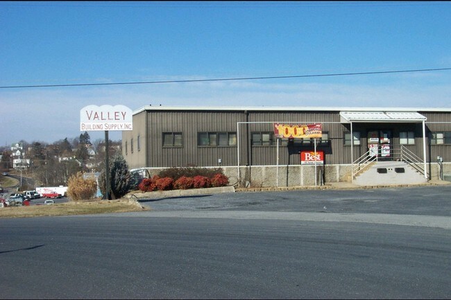
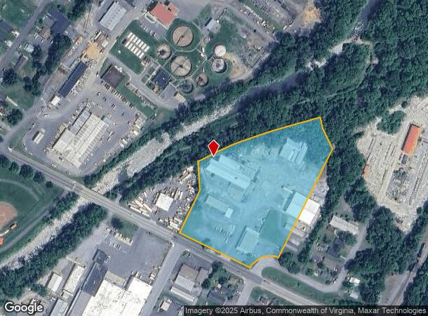
Property Record
801 2Nd St, Waynesboro, VA 22980
NEARBY LISTINGS FOR SALE OR LEASE
Property Detail
801 2Nd St
37-2-7
Small Acreage
Commercialnec
7.483 ACRES SMALL ACREAGE
AE
Waynesboro
51125C0050C
Virginia
2025
7.48 AC
2025
Staunton & Harrisonburg
003200
Other Market Areas
9,468 SF
Staunton-Waynesboro, VA
DEMOGRAPHICS near 801 2Nd St
1 Mile
3 Mile
5 Mile
2024 Total Population
7,412
23,227
32,799
2029 Population
8,024
24,921
34,817
Pop Growth 2024-2029
+ 8.26%
+ 7.29%
+ 6.15%
Average Age
39
42
43
2024 Total Households
3,134
9,936
13,921
HH Growth 2024-2029
+ 8.30%
+ 7.30%
+ 6.19%
Median Household Inc
$37,234
$50,006
$54,848
Avg Household Size
2.30
2.30
2.30
2024 Avg HH Vehicles
2.00
2.00
2.00
Median Home Value
$152,650
$201,594
$236,383
Median Year Built
1975
1973
1978
Nearby Places
Map Layers
Map Styles
 Street
 Aerial
- Restaurants
- Banks
- Shops
- Fitness
- Groceries
PUBLIC TRANSPORTATION
AIRPORT
Charlottesville-Albemarle
DRIVE
WALK
Distance
Charlottesville-Albemarle
51 min
34.9 mi
Freight Ports
Virginia Port Authority - Richmond
DRIVE
WALK
Distance
Virginia Port Authority - Richmond
122 min
102.9 mi
Nearby Properties
Address
Land Use
TOTAL SIZE
Lot Size
Zoning
Address
Land Use
TOTAL SIZE
Lot Size
Zoning
150,944 SF
22.24 AC
RG-5
Address
Land Use
TOTAL SIZE
Lot Size
Zoning
165,670 SF
5.31 AC
R-O
Address
Land Use
TOTAL SIZE
Lot Size
Zoning
2.08 AC
RG-5
Address
Land Use
TOTAL SIZE
Lot Size
Zoning
48,888 SF
9.01 AC
RG-5
Address
Land Use
TOTAL SIZE
Lot Size
Zoning
121,275 SF
18.39 AC
RG-5
Address
Land Use
TOTAL SIZE
Lot Size
Zoning
947 SF
13.62 AC
RG-5
Address
Land Use
TOTAL SIZE
Lot Size
Zoning
301,338 SF
21.52 AC
H-I
Address
Land Use
TOTAL SIZE
Lot Size
Zoning
75,609 SF
12.01 AC
RS-7
Address
Land Use
TOTAL SIZE
Lot Size
Zoning
96,070 SF
27.10 AC
H-B
Address
Land Use
TOTAL SIZE
Lot Size
Zoning
5,624 SF
74.80 AC
H-I
Address
Land Use
TOTAL SIZE
Lot Size
Zoning
31,977 SF
5.07 AC
RS-12
Address
Land Use
TOTAL SIZE
Lot Size
Zoning
460 SF
144.09 AC
H-I
Address
Land Use
TOTAL SIZE
Lot Size
Zoning
7,512 SF
6.39 AC
R-MF
Address
Land Use
TOTAL SIZE
Lot Size
Zoning
1,844 SF
8.39 AC
R-MF
Address
Land Use
TOTAL SIZE
Lot Size
Zoning
2,460 SF
31.78 AC
PUD
Address
Land Use
TOTAL SIZE
Lot Size
Zoning
840 SF
1.70 AC
C-B
Address
Land Use
TOTAL SIZE
Lot Size
Zoning
41,574 SF
5.29 AC
H-B
Address
Land Use
TOTAL SIZE
Lot Size
Zoning
2,393 SF
6.81 AC
R-MF
Address
Land Use
TOTAL SIZE
Lot Size
Zoning
7,128 SF
3.75 AC
R-MF
Address
Land Use
TOTAL SIZE
Lot Size
Zoning
7,178 SF
4.16 AC
R-MF
Address
Land Use
TOTAL SIZE
Lot Size
Zoning
62,626 SF
1.15 AC
R-MF
Address
Land Use
TOTAL SIZE
Lot Size
Zoning
54,021 SF
9.74 AC
RS-7
Address
Land Use
TOTAL SIZE
Lot Size
Zoning
36,698 SF
0.90 AC
R-MF
Address
Land Use
TOTAL SIZE
Lot Size
Zoning
1,000 SF
4.17 AC
H-B
Address
Land Use
TOTAL SIZE
Lot Size
Zoning
42,122 SF
8 AC
RG-5
Address
Land Use
TOTAL SIZE
Lot Size
Zoning
106,752 SF
7.76 AC
H-I
Address
Land Use
TOTAL SIZE
Lot Size
Zoning
301,313 SF
55.86 AC
H-I
Address
Land Use
TOTAL SIZE
Lot Size
Zoning
18,730 SF
2.43 AC
L-I
Address
Land Use
TOTAL SIZE
Lot Size
Zoning
16,324 SF
15.91 AC
H-B
Address
Land Use
TOTAL SIZE
Lot Size
Zoning
4,096 SF
2.24 AC
RG-5
The World's #1 Commercial Real Estate Marketplace
Connect with us
© 2025 CoStar Group
The information above has been obtained from sources believed reliable. While we do not doubt its accuracy we have not verified it and make no guarantee, warranty or representation about it. It is your responsibility to independently confirm its accuracy and completeness. Any projections, opinions, assumptions, or estimates used are for example only and do not represent the current or future performance of the property. The value of this transaction to you depends on tax and other factors which should be evaluated by your tax, financial, and legal advisors. You and your advisors should conduct a careful, independent investigation of the property to determine to your satisfaction the suitability of the property for your needs.