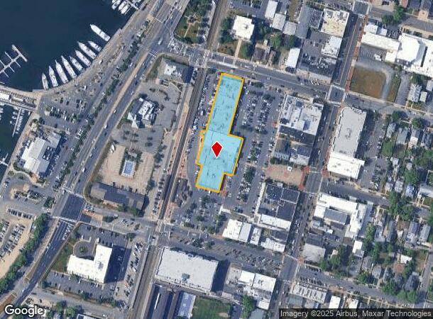
Property Record
Belmar Plz, Belmar, NJ 07719
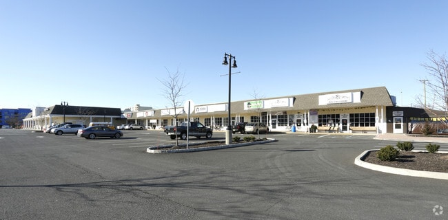
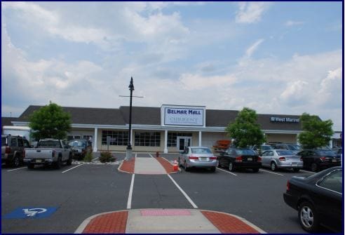
Current Lease Availabilities
NEARBY LISTINGS FOR SALE OR LEASE
Property Detail
Belmar Plz
07-00086-01-00001
Monmouth
Regionalshoppingcenterormallwithanchorstore
New Jersey
X
1
34025C0342G
1.10 AC
2024
Southern Monmouth
2025
Northern New Jersey
808501
New York-Jersey City-White Plains, NY-NJ
45,200 SF
DEMOGRAPHICS near Belmar Plz
1 Mile
3 Mile
5 Mile
2024 Total Population
13,951
76,374
129,360
2029 Population
14,348
77,748
131,274
Pop Growth 2024-2029
+ 2.85%
+ 1.80%
+ 1.48%
Average Age
45
44
45
2024 Total Households
6,540
33,384
55,801
HH Growth 2024-2029
+ 2.86%
+ 1.97%
+ 1.53%
Median Household Inc
$94,362
$86,778
$96,646
Avg Household Size
2.10
2.20
2.20
2024 Avg HH Vehicles
2.00
2.00
2.00
Median Home Value
$626,608
$547,376
$589,813
Median Year Built
1958
1962
1965
Nearby Places
- Restaurants
- Banks
- Shops
- Fitness
- Groceries
PUBLIC TRANSPORTATION
COMMUTER RAIL
Belmar (North Jersey Coast Line - NJ Transit Commuter Rail (NJ Transit))
DRIVE
WALK
Distance
Belmar (North Jersey Coast Line - NJ Transit Commuter Rail (NJ Transit))
1 min
2 min
0.1 mi
Bradley Beach (North Jersey Coast Line - NJ Transit Commuter Rail (NJ Transit))
DRIVE
WALK
Distance
Bradley Beach (North Jersey Coast Line - NJ Transit Commuter Rail (NJ Transit))
3 min
1.7 mi
Freight Ports
New York Container Terminal
DRIVE
WALK
Distance
New York Container Terminal
58 min
44.6 mi
Nearby Properties
Address
Land Use
TOTAL SIZE
Lot Size
Zoning
Address
Land Use
TOTAL SIZE
Lot Size
Zoning
26,282 SF
4.59 AC
C
Address
Land Use
TOTAL SIZE
Lot Size
Zoning
2,596 SF
54.13 AC
SF10
Address
Land Use
TOTAL SIZE
Lot Size
Zoning
5,776 SF
25.50 AC
PB
Address
Land Use
TOTAL SIZE
Lot Size
Zoning
739,651 SF
27.89 AC
C
Address
Land Use
TOTAL SIZE
Lot Size
Zoning
1,846 SF
23.23 AC
R-2
Address
Land Use
TOTAL SIZE
Lot Size
Zoning
320,341 SF
57.85 AC
C
Address
Land Use
TOTAL SIZE
Lot Size
Zoning
23,868 SF
137.35 AC
R-1
Address
Land Use
TOTAL SIZE
Lot Size
Zoning
1.61 AC
R1
Address
Land Use
TOTAL SIZE
Lot Size
Zoning
190,893 SF
36.69 AC
POS
Address
Land Use
TOTAL SIZE
Lot Size
Zoning
1,152 SF
87 SF
WPRA
Address
Land Use
TOTAL SIZE
Lot Size
Zoning
108,641 SF
10.64 AC
C-6
Address
Land Use
TOTAL SIZE
Lot Size
Zoning
49,657 SF
11.22 AC
HB80
Address
Land Use
TOTAL SIZE
Lot Size
Zoning
1,288 SF
25.49 AC
HD-R
Address
Land Use
TOTAL SIZE
Lot Size
Zoning
20,959 SF
3.10 AC
R-1
Address
Land Use
TOTAL SIZE
Lot Size
Zoning
3.44 AC
R-2
Address
Land Use
TOTAL SIZE
Lot Size
Zoning
3,094 SF
277.60 AC
C
Address
Land Use
TOTAL SIZE
Lot Size
Zoning
91,173 SF
4.07 AC
R3
Address
Land Use
TOTAL SIZE
Lot Size
Zoning
254,714 SF
3.40 AC
WPRA
Address
Land Use
TOTAL SIZE
Lot Size
Zoning
9.30 AC
SF05
Address
Land Use
TOTAL SIZE
Lot Size
Zoning
3.44 AC
SF05
Address
Land Use
TOTAL SIZE
Lot Size
Zoning
Address
Land Use
TOTAL SIZE
Lot Size
Zoning
1,487 SF
7.50 AC
R-B
Address
Land Use
TOTAL SIZE
Lot Size
Zoning
0.88 AC
STNB
Address
Land Use
TOTAL SIZE
Lot Size
Zoning
8.82 AC
R2
Address
Land Use
TOTAL SIZE
Lot Size
Zoning
27,328 SF
6.79 AC
HB12
Address
Land Use
TOTAL SIZE
Lot Size
Zoning
26.05 AC
SF10
Address
Land Use
TOTAL SIZE
Lot Size
Zoning
0.86 AC
R-1
Address
Land Use
TOTAL SIZE
Lot Size
Zoning
7.39 AC
R2
Address
Land Use
TOTAL SIZE
Lot Size
Zoning
8.76 AC
R1
Address
Land Use
TOTAL SIZE
Lot Size
Zoning
86,051 SF
9.41 AC
HB12
The World's #1 Commercial Real Estate Marketplace
Connect with us
© 2025 CoStar Group
The information above has been obtained from sources believed reliable. While we do not doubt its accuracy we have not verified it and make no guarantee, warranty or representation about it. It is your responsibility to independently confirm its accuracy and completeness. Any projections, opinions, assumptions, or estimates used are for example only and do not represent the current or future performance of the property. The value of this transaction to you depends on tax and other factors which should be evaluated by your tax, financial, and legal advisors. You and your advisors should conduct a careful, independent investigation of the property to determine to your satisfaction the suitability of the property for your needs.