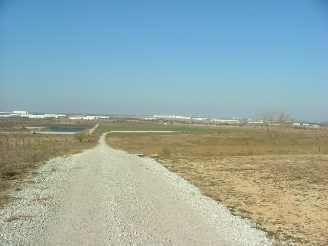
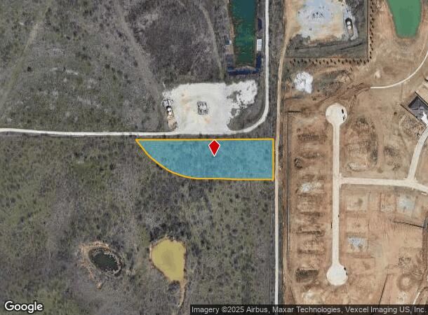
Property Record
801 Blue Mound Rd E, Haslet, TX 76052
NEARBY LISTINGS FOR SALE OR LEASE
Property Detail
801 Blue Mound Rd E
Dallas-Fort Worth-Arlington, TX
Hopkins, Eldridge Survey
03919552
HOPKINS, ELDRIDGE SURVEY ABSTRACT 646 TRACT 1C01
Residentialacreage
Tarrant
X
Texas
48121C0630G
2.46 AC
2024
Alliance
2024
Dallas/Ft Worth
114111
DEMOGRAPHICS near 801 Blue Mound Rd E
1 Mile
3 Mile
5 Mile
2024 Total Population
1,620
55,388
174,283
2029 Population
1,801
58,650
185,248
Pop Growth 2024-2029
+ 11.17%
+ 5.89%
+ 6.29%
Average Age
42
34
34
2024 Total Households
586
18,163
55,857
HH Growth 2024-2029
+ 11.43%
+ 5.81%
+ 6.32%
Median Household Inc
$142,307
$106,463
$106,828
Avg Household Size
2.80
3.00
3.10
2024 Avg HH Vehicles
3.00
2.00
2.00
Median Home Value
$449,382
$299,530
$301,481
Median Year Built
2010
2008
2008
Nearby Places
Map Layers
Map Styles
 Street
 Aerial
- Restaurants
- Banks
- Shops
- Fitness
- Groceries
PUBLIC TRANSPORTATION
AIRPORT
Dallas-Fort Worth International
DRIVE
WALK
Distance
Dallas-Fort Worth International
31 min
23.4 mi
Dallas Love Field
DRIVE
WALK
Distance
Dallas Love Field
50 min
37.1 mi
Freight Ports
Port of Shreveport
DRIVE
WALK
Distance
Port of Shreveport
260 min
236.9 mi
Nearby Properties
Address
Land Use
TOTAL SIZE
Lot Size
Zoning
Address
Land Use
TOTAL SIZE
Lot Size
Zoning
348,270 SF
39.34 AC
Address
Land Use
TOTAL SIZE
Lot Size
Zoning
252,365 SF
20.53 AC
Address
Land Use
TOTAL SIZE
Lot Size
Zoning
471,408 SF
17.56 AC
Address
Land Use
TOTAL SIZE
Lot Size
Zoning
1,150,000 SF
117.10 AC
Address
Land Use
TOTAL SIZE
Lot Size
Zoning
1,141,133 SF
67.79 AC
Address
Land Use
TOTAL SIZE
Lot Size
Zoning
362,688 SF
34.18 AC
Address
Land Use
TOTAL SIZE
Lot Size
Zoning
504,000 SF
26.39 AC
Address
Land Use
TOTAL SIZE
Lot Size
Zoning
882,565 SF
56.65 AC
Address
Land Use
TOTAL SIZE
Lot Size
Zoning
340,366 SF
53 AC
Address
Land Use
TOTAL SIZE
Lot Size
Zoning
259,825 SF
14.95 AC
Address
Land Use
TOTAL SIZE
Lot Size
Zoning
1,140,525 SF
45.79 AC
Address
Land Use
TOTAL SIZE
Lot Size
Zoning
270,000 SF
42.20 AC
Address
Land Use
TOTAL SIZE
Lot Size
Zoning
377,934 SF
16.02 AC
Address
Land Use
TOTAL SIZE
Lot Size
Zoning
308,713 SF
17.58 AC
Address
Land Use
TOTAL SIZE
Lot Size
Zoning
807,229 SF
46.10 AC
Address
Land Use
TOTAL SIZE
Lot Size
Zoning
295,161 SF
257.32 AC
Address
Land Use
TOTAL SIZE
Lot Size
Zoning
279,612 SF
18.46 AC
Address
Land Use
TOTAL SIZE
Lot Size
Zoning
727,900 SF
40.15 AC
Address
Land Use
TOTAL SIZE
Lot Size
Zoning
412,258 SF
12.62 AC
Address
Land Use
TOTAL SIZE
Lot Size
Zoning
707,940 SF
35.33 AC
Address
Land Use
TOTAL SIZE
Lot Size
Zoning
268,573 SF
11.09 AC
Address
Land Use
TOTAL SIZE
Lot Size
Zoning
677,700 SF
42.17 AC
Address
Land Use
TOTAL SIZE
Lot Size
Zoning
267,831 SF
17.40 AC
Address
Land Use
TOTAL SIZE
Lot Size
Zoning
222,672 SF
8.73 AC
Address
Land Use
TOTAL SIZE
Lot Size
Zoning
634,042 SF
35.88 AC
Address
Land Use
TOTAL SIZE
Lot Size
Zoning
418,271 SF
43.10 AC
Address
Land Use
TOTAL SIZE
Lot Size
Zoning
562,500 SF
29.64 AC
Address
Land Use
TOTAL SIZE
Lot Size
Zoning
731,548 SF
56.18 AC
Address
Land Use
TOTAL SIZE
Lot Size
Zoning
174,438 SF
12.38 AC
Address
Land Use
TOTAL SIZE
Lot Size
Zoning
212,381 SF
8.05 AC
The World's #1 Commercial Real Estate Marketplace
Connect with us
© 2026 CoStar Group
The information above has been obtained from sources believed reliable. While we do not doubt its accuracy we have not verified it and make no guarantee, warranty or representation about it. It is your responsibility to independently confirm its accuracy and completeness. Any projections, opinions, assumptions, or estimates used are for example only and do not represent the current or future performance of the property. The value of this transaction to you depends on tax and other factors which should be evaluated by your tax, financial, and legal advisors. You and your advisors should conduct a careful, independent investigation of the property to determine to your satisfaction the suitability of the property for your needs.