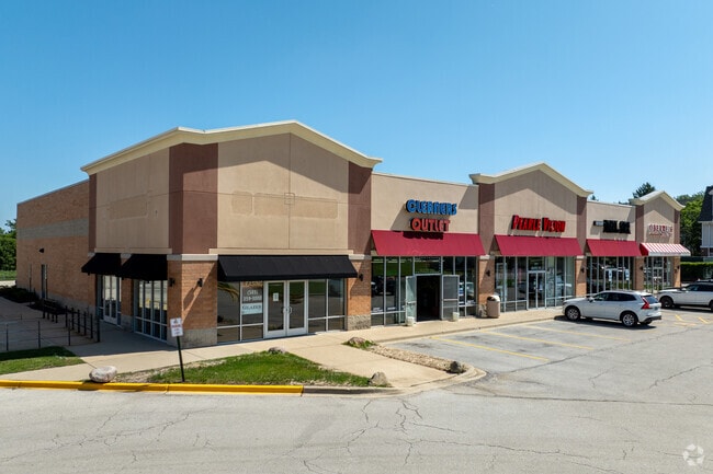
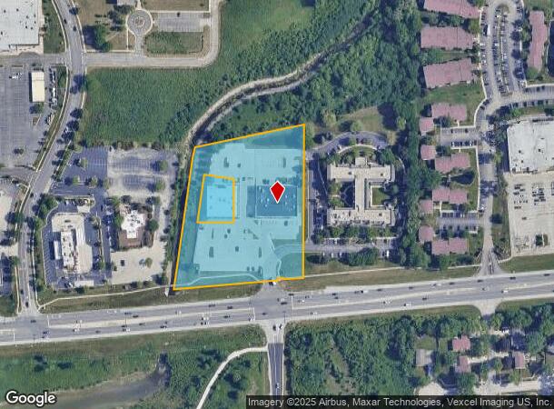
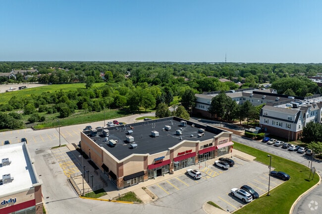
Property Record
801 Butterfield Rd, Wheaton, IL 60189
NEARBY LISTINGS FOR SALE OR LEASE
Property Detail
801 Butterfield Rd
Chicago
Guiness Resub
Chicago-Naperville-Elgin, IL-IN
GUINESS RESUB /EX HWY DESC R24-044371 23ED5/
05-28-403-034
DuPage
Commercialnec
Illinois
2024
3.77 AC
2024
Western East/West Corr
842702
DEMOGRAPHICS near 801 Butterfield Rd
1 Mile
3 Mile
5 Mile
2024 Total Population
9,728
76,659
233,227
2029 Population
9,520
75,109
229,213
Pop Growth 2024-2029
(2.14%)
(2.02%)
(1.72%)
Average Age
41
40
41
2024 Total Households
3,962
29,759
90,994
HH Growth 2024-2029
(2.40%)
(2.09%)
(1.71%)
Median Household Inc
$109,791
$107,286
$106,860
Avg Household Size
2.40
2.40
2.40
2024 Avg HH Vehicles
2.00
2.00
2.00
Median Home Value
$420,624
$407,633
$405,558
Median Year Built
1980
1975
1976
Nearby Places
Map Layers
Map Styles
 Street
 Aerial
- Restaurants
- Banks
- Shops
- Fitness
- Groceries
PUBLIC TRANSPORTATION
COMMUTER RAIL
Wheaton Station (Union Pacific West Line - Northeast Illinois Regional Commuter Railroad (Metra))
DRIVE
WALK
Distance
Wheaton Station (Union Pacific West Line - Northeast Illinois Regional Commuter Railroad (Metra))
10 min
3.6 mi
College Avenue Station (Union Pacific West Line - Northeast Illinois Regional Commuter Railroad (Metra))
DRIVE
WALK
Distance
College Avenue Station (Union Pacific West Line - Northeast Illinois Regional Commuter Railroad (Metra))
8 min
3.9 mi
AIRPORT
Chicago O'Hare International
DRIVE
WALK
Distance
Chicago O'Hare International
25 min
22.0 mi
Chicago Midway International
DRIVE
WALK
Distance
Chicago Midway International
36 min
28.6 mi
Freight Ports
Port of Baltimore
DRIVE
WALK
Distance
Port of Baltimore
1 min
628.6 mi
SALE & LEASE HISTORY
LISTING DATE
SALE/LEASE

Apr 18, 2017
For Lease
Nearby Properties
Address
Land Use
TOTAL SIZE
Lot Size
Zoning
Address
Land Use
TOTAL SIZE
Lot Size
Zoning
818,262 SF
13.70 AC
M
Address
Land Use
TOTAL SIZE
Lot Size
Zoning
83.99 AC
Address
Land Use
TOTAL SIZE
Lot Size
Zoning
594,125 SF
2.60 AC
Address
Land Use
TOTAL SIZE
Lot Size
Zoning
Address
Land Use
TOTAL SIZE
Lot Size
Zoning
8.08 AC
C
Address
Land Use
TOTAL SIZE
Lot Size
Zoning
Address
Land Use
TOTAL SIZE
Lot Size
Zoning
295,773 SF
17.45 AC
M
Address
Land Use
TOTAL SIZE
Lot Size
Zoning
264,227 SF
17.12 AC
M
Address
Land Use
TOTAL SIZE
Lot Size
Zoning
254,992 SF
14.21 AC
M
Address
Land Use
TOTAL SIZE
Lot Size
Zoning
300,104 SF
19.49 AC
M
Address
Land Use
TOTAL SIZE
Lot Size
Zoning
254,201 SF
27.84 AC
Address
Land Use
TOTAL SIZE
Lot Size
Zoning
20.05 AC
C
Address
Land Use
TOTAL SIZE
Lot Size
Zoning
9.18 AC
C
Address
Land Use
TOTAL SIZE
Lot Size
Zoning
15.33 AC
I
Address
Land Use
TOTAL SIZE
Lot Size
Zoning
8.36 AC
C
Address
Land Use
TOTAL SIZE
Lot Size
Zoning
201,048 SF
20.24 AC
Address
Land Use
TOTAL SIZE
Lot Size
Zoning
146,492 SF
0.42 AC
Address
Land Use
TOTAL SIZE
Lot Size
Zoning
259,374 SF
27.66 AC
C
Address
Land Use
TOTAL SIZE
Lot Size
Zoning
2.37 AC
Address
Land Use
TOTAL SIZE
Lot Size
Zoning
13.67 AC
M
Address
Land Use
TOTAL SIZE
Lot Size
Zoning
14.68 AC
I
Address
Land Use
TOTAL SIZE
Lot Size
Zoning
16.26 AC
C
Address
Land Use
TOTAL SIZE
Lot Size
Zoning
13.89 AC
M
Address
Land Use
TOTAL SIZE
Lot Size
Zoning
162,819 SF
19.82 AC
C
Address
Land Use
TOTAL SIZE
Lot Size
Zoning
13.27 AC
M
Address
Land Use
TOTAL SIZE
Lot Size
Zoning
162,815 SF
11.60 AC
M
Address
Land Use
TOTAL SIZE
Lot Size
Zoning
13.44 AC
C
Address
Land Use
TOTAL SIZE
Lot Size
Zoning
240,918 SF
8.13 AC
C
Address
Land Use
TOTAL SIZE
Lot Size
Zoning
14.34 AC
C
Address
Land Use
TOTAL SIZE
Lot Size
Zoning
46.10 AC
The World's #1 Commercial Real Estate Marketplace
Connect with us
© 2026 CoStar Group
The information above has been obtained from sources believed reliable. While we do not doubt its accuracy we have not verified it and make no guarantee, warranty or representation about it. It is your responsibility to independently confirm its accuracy and completeness. Any projections, opinions, assumptions, or estimates used are for example only and do not represent the current or future performance of the property. The value of this transaction to you depends on tax and other factors which should be evaluated by your tax, financial, and legal advisors. You and your advisors should conduct a careful, independent investigation of the property to determine to your satisfaction the suitability of the property for your needs.