Property Record
801 Dalton St, Richland, WA 99354
Current Lease Availabilities
NEARBY LISTINGS FOR SALE OR LEASE
Property Detail
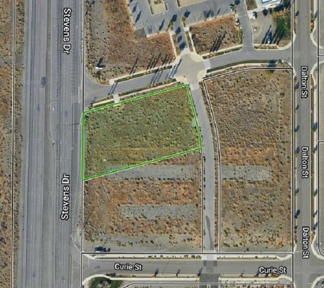
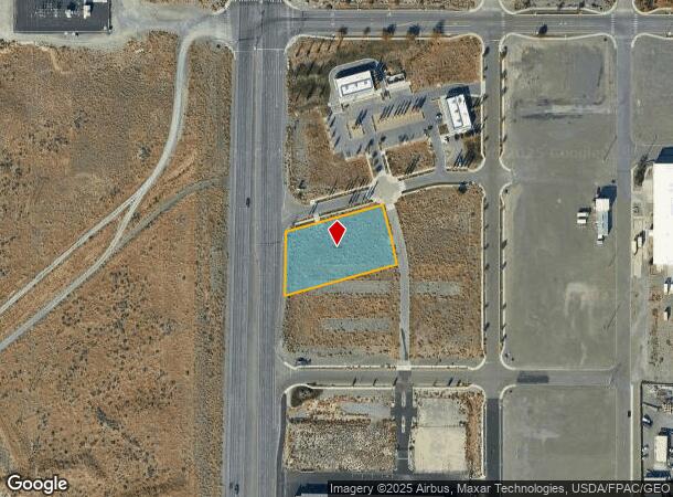
801 Dalton St
Other Market Areas
Short Plat #3398
Kennewick-Richland, WA
SECTION 23, TOWNSHIP 10 NORTH, RANGE 28 EAST, QUARTER SW: SHORT PLAT #3398, LOT 2. RECORDED IN VOLUME 1 OF SHORT PLATS, PAGE 3398, RECORDS OF BENTON COUNTY, WASHINGTON. AF#2013-019453, 6/07/2013.
123083013398002
Benton
Industrialgeneral
Washington
2024
2
2024
0.92 AC
010203
Yakima/Kennewick
DEMOGRAPHICS near 801 Dalton St
1 Mile
3 Mile
5 Mile
2024 Total Population
2,131
22,231
51,996
2029 Population
2,280
23,880
55,939
Pop Growth 2024-2029
+ 6.99%
+ 7.42%
+ 7.58%
Average Age
40
40
39
2024 Total Households
1,102
9,098
20,364
HH Growth 2024-2029
+ 6.72%
+ 7.39%
+ 7.58%
Median Household Inc
$82,608
$83,656
$84,615
Avg Household Size
1.90
2.40
2.50
2024 Avg HH Vehicles
2.00
2.00
2.00
Median Home Value
$339,141
$348,484
$339,836
Median Year Built
2000
1974
1975
Nearby Places
- Restaurants
- Banks
- Shops
- Fitness
- Groceries
PUBLIC TRANSPORTATION
AIRPORT
Tri-Cities
DRIVE
WALK
Distance
Tri-Cities
24 min
15.9 mi
Freight Ports
Port of Tacoma
DRIVE
WALK
Distance
Port of Tacoma
262 min
214.9 mi
Nearby Properties
Address
Land Use
TOTAL SIZE
Lot Size
Zoning
Address
Land Use
TOTAL SIZE
Lot Size
Zoning
650,794 SF
55.19 AC
Address
Land Use
TOTAL SIZE
Lot Size
Zoning
351,518 SF
16.01 AC
Address
Land Use
TOTAL SIZE
Lot Size
Zoning
14,514 SF
160 AC
Address
Land Use
TOTAL SIZE
Lot Size
Zoning
5,948 SF
25 AC
Address
Land Use
TOTAL SIZE
Lot Size
Zoning
305,328 SF
83.37 AC
Address
Land Use
TOTAL SIZE
Lot Size
Zoning
12,866 SF
44.02 AC
Address
Land Use
TOTAL SIZE
Lot Size
Zoning
245,782 SF
10 AC
RICHLAND -
Address
Land Use
TOTAL SIZE
Lot Size
Zoning
148,367 SF
1 AC
Address
Land Use
TOTAL SIZE
Lot Size
Zoning
306,563 SF
14.60 AC
Address
Land Use
TOTAL SIZE
Lot Size
Zoning
277,559 SF
30 AC
Address
Land Use
TOTAL SIZE
Lot Size
Zoning
201,040 SF
4.24 AC
Address
Land Use
TOTAL SIZE
Lot Size
Zoning
719,130 SF
75 AC
RICHLAND -
Address
Land Use
TOTAL SIZE
Lot Size
Zoning
47,160 SF
14.28 AC
Address
Land Use
TOTAL SIZE
Lot Size
Zoning
280,136 SF
Address
Land Use
TOTAL SIZE
Lot Size
Zoning
106,500 SF
3.83 AC
Address
Land Use
TOTAL SIZE
Lot Size
Zoning
90,520 SF
4.32 AC
RICHLAND -
Address
Land Use
TOTAL SIZE
Lot Size
Zoning
94,714 SF
5.22 AC
Address
Land Use
TOTAL SIZE
Lot Size
Zoning
100,872 SF
1 AC
Address
Land Use
TOTAL SIZE
Lot Size
Zoning
100,872 SF
1 AC
Address
Land Use
TOTAL SIZE
Lot Size
Zoning
233,709 SF
39.16 AC
Address
Land Use
TOTAL SIZE
Lot Size
Zoning
69,697 SF
16.83 AC
Address
Land Use
TOTAL SIZE
Lot Size
Zoning
150,522 SF
Address
Land Use
TOTAL SIZE
Lot Size
Zoning
93,484 SF
61.65 AC
Address
Land Use
TOTAL SIZE
Lot Size
Zoning
96,486 SF
13.24 AC
Address
Land Use
TOTAL SIZE
Lot Size
Zoning
99,320 SF
5.37 AC
Address
Land Use
TOTAL SIZE
Lot Size
Zoning
208,285 SF
5.24 AC
Address
Land Use
TOTAL SIZE
Lot Size
Zoning
80,597 SF
6.37 AC
Address
Land Use
TOTAL SIZE
Lot Size
Zoning
136,013 SF
7.09 AC
Address
Land Use
TOTAL SIZE
Lot Size
Zoning
160,160 SF
16.25 AC
58
Address
Land Use
TOTAL SIZE
Lot Size
Zoning
26,182 SF
3.62 AC
The World's #1 Commercial Real Estate Marketplace
Connect with us
© 2025 CoStar Group
The information above has been obtained from sources believed reliable. While we do not doubt its accuracy we have not verified it and make no guarantee, warranty or representation about it. It is your responsibility to independently confirm its accuracy and completeness. Any projections, opinions, assumptions, or estimates used are for example only and do not represent the current or future performance of the property. The value of this transaction to you depends on tax and other factors which should be evaluated by your tax, financial, and legal advisors. You and your advisors should conduct a careful, independent investigation of the property to determine to your satisfaction the suitability of the property for your needs.