Property Record
801 E 1St St, Grimes, IA 50111

Save to a Folder
{{folder.Name}}
{{folder.ListingIds.length}} Properties
{{folder.ListingIds.length}} Property
Create a New Folder
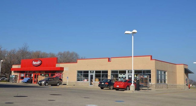
Property Detail
801 E 1St St
311-00052002000
PARCEL L BK 13174 PG 149 BEG 33.12F E & 74.76F N OF SW COR THN N 260.16F E 282.06F SE 72.43F SW 47.71F S 115.46F SW 26.88F TO N LN 1ST ST W 278.13F TO POB & PARCEL N BK 13174 PG 149 COM SW COR THN E 33.12F N 74.76F E 278.13F TO BEG THN NE 26.88F N 11
Storebuilding
Polk
C-2
Iowa
AE The base floodplain where base flood elevations are provided. AE Zones are now used on new format FIRMs instead of A1-A30 Zones.
2 AC
2024
Western Suburbs
2025
Des Moines
011303
Des Moines-West Des Moines, IA
5,736 SF
NEARBY LISTINGS FOR SALE OR LEASE
DEMOGRAPHICS near 801 E 1St St
1 mile
3 mile
5 mile
2025 Total Population
9,503
31,644
74,588
2030 Population
10,079
33,360
78,943
Pop Growth 2025-2030
+ 6.06%
+ 5.42%
+ 5.84%
Average Age
35
36
38
2025 Total Households
3,519
11,658
28,034
HH Growth 2025-2030
+ 6.17%
+ 5.54%
+ 5.91%
Median Household Inc
$104,813
$119,896
$118,879
Avg Household Size
2.70
2.70
2.60
2025 Avg HH Vehicles
2.00
2.00
2.00
Median Home Value
$332,632
$358,957
$363,221
Median Year Built
2010
2008
2002
Nearby Places
Map Layers
Map Styles
 Street
 Aerial
Layers
 Traffic
 Biking
Places
Listings with unknown addresses are not visible on the map
- Restaurants
- Banks
- Shops
- Fitness
- Groceries
PUBLIC TRANSPORTATION
AIRPORT
Des Moines International
Drive
Walk
Distance
Des Moines International
32 min
18.2 mi
Freight Ports
Port Milwaukee
Drive
Walk
Distance
Port Milwaukee
427 min
382.4 mi
Nearby Properties
Address
Land Use
TOTAL SIZE
Lot Size
Zoning
Address
Land Use
TOTAL SIZE
Lot Size
Zoning
330,704 SF
15.86 AC
Address
Land Use
TOTAL SIZE
Lot Size
Zoning
386,976 SF
30 AC
Address
Land Use
TOTAL SIZE
Lot Size
Zoning
300,000 SF
17.51 AC
Address
Land Use
TOTAL SIZE
Lot Size
Zoning
270,000 SF
19.10 AC
Address
Land Use
TOTAL SIZE
Lot Size
Zoning
260,000 SF
14.32 AC
Address
Land Use
TOTAL SIZE
Lot Size
Zoning
269,700 SF
16.53 AC
Address
Land Use
TOTAL SIZE
Lot Size
Zoning
260,000 SF
18.45 AC
Address
Land Use
TOTAL SIZE
Lot Size
Zoning
235,422 SF
13.39 AC
Address
Land Use
TOTAL SIZE
Lot Size
Zoning
250,000 SF
13.93 AC
Address
Land Use
TOTAL SIZE
Lot Size
Zoning
245,520 SF
19.33 AC
Address
Land Use
TOTAL SIZE
Lot Size
Zoning
77.75 AC
Address
Land Use
TOTAL SIZE
Lot Size
Zoning
14.60 AC
Address
Land Use
TOTAL SIZE
Lot Size
Zoning
127,869 SF
6.70 AC
Address
Land Use
TOTAL SIZE
Lot Size
Zoning
35.81 AC
Address
Land Use
TOTAL SIZE
Lot Size
Zoning
219,950 SF
22.57 AC
Address
Land Use
TOTAL SIZE
Lot Size
Zoning
200,000 SF
14.57 AC
Address
Land Use
TOTAL SIZE
Lot Size
Zoning
181,984 SF
16.42 AC
Address
Land Use
TOTAL SIZE
Lot Size
Zoning
91,733 SF
13 AC
Address
Land Use
TOTAL SIZE
Lot Size
Zoning
187,816 SF
21.51 AC
M-2
Address
Land Use
TOTAL SIZE
Lot Size
Zoning
84,315 SF
20.59 AC
M2
Address
Land Use
TOTAL SIZE
Lot Size
Zoning
198,944 SF
8.61 AC
Address
Land Use
TOTAL SIZE
Lot Size
Zoning
197,966 SF
10.09 AC
Address
Land Use
TOTAL SIZE
Lot Size
Zoning
101,234 SF
7.49 AC
Address
Land Use
TOTAL SIZE
Lot Size
Zoning
144,545 SF
11.94 AC
Address
Land Use
TOTAL SIZE
Lot Size
Zoning
160,416 SF
23.78 AC
C-2
Address
Land Use
TOTAL SIZE
Lot Size
Zoning
110,000 SF
8.88 AC
Address
Land Use
TOTAL SIZE
Lot Size
Zoning
135,000 SF
18.15 AC
Address
Land Use
TOTAL SIZE
Lot Size
Zoning
50,564 SF
13.14 AC
R-1 (60)
Address
Land Use
TOTAL SIZE
Lot Size
Zoning
60,670 SF
55.65 AC
M-1A
Address
Land Use
TOTAL SIZE
Lot Size
Zoning
52,959 SF
4.76 AC
The World's #1 Commercial Real Estate Marketplace
Connect with us
© 2026 CoStar Group
The information above has been obtained from sources believed reliable. While we do not doubt its accuracy we have not verified it and make no guarantee, warranty or representation about it. It is your responsibility to independently confirm its accuracy and completeness. Any projections, opinions, assumptions, or estimates used are for example only and do not represent the current or future performance of the property. The value of this transaction to you depends on tax and other factors which should be evaluated by your tax, financial, and legal advisors. You and your advisors should conduct a careful, independent investigation of the property to determine to your satisfaction the suitability of the property for your needs.