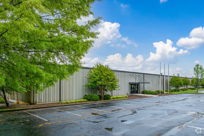
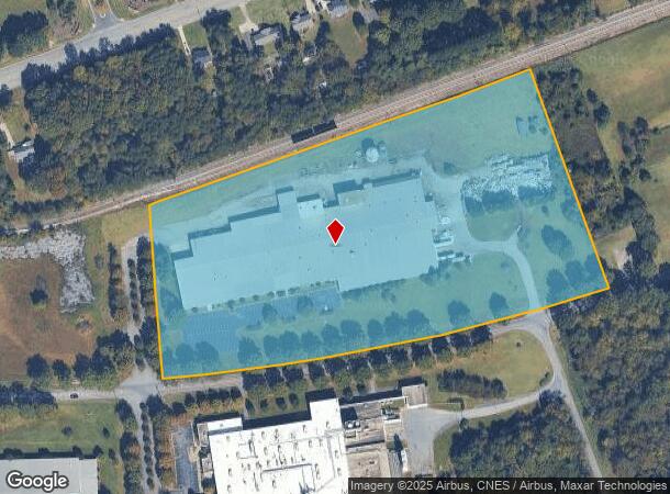
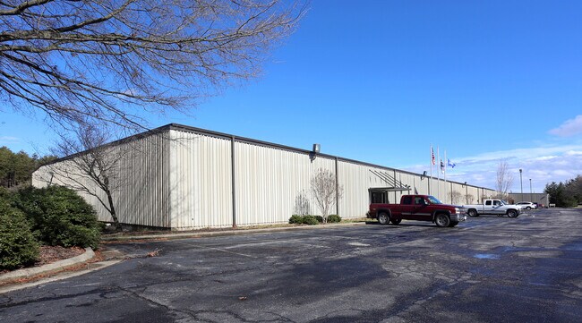
Property Record
801 W Fieldcrest Rd, Eden, NC 27288
NEARBY LISTINGS FOR SALE OR LEASE
Property Detail
801 W Fieldcrest Rd
173470
As Built Survey For Pluma Inc
Manufacturinglight
17 AC FIELDCREST RD
X
Rockingham
51143C0590E
North Carolina
2025
17 AC
2025
Rockingham County
040200
Greensboro/Winston-Salem
172,252 SF
Greensboro-High Point, NC
DEMOGRAPHICS near 801 W Fieldcrest Rd
1 mile
3 mile
5 mile
2024 Total Population
1,785
11,629
22,481
2029 Population
1,845
12,001
23,159
Pop Growth 2024-2029
+ 3.36%
+ 3.20%
+ 3.02%
Average Age
40
42
43
2024 Total Households
738
5,090
9,787
HH Growth 2024-2029
+ 3.25%
+ 3.10%
+ 2.94%
Median Household Inc
$30,454
$38,251
$38,977
Avg Household Size
2.30
2.20
2.20
2024 Avg HH Vehicles
2.00
2.00
2.00
Median Home Value
$95,544
$106,512
$113,441
Median Year Built
1954
1969
1968
Nearby Places
Map Layers
Map Styles
 Street
 Aerial
Transit
 Traffic
 Biking
Places
Listings with unknown addresses are not visible on the map
- Restaurants
- Banks
- Shops
- Fitness
- Groceries
SALE & LEASE HISTORY
LISTING DATE
SALE/LEASE

Jul 05, 2017
For Lease
Jan 24, 2022
For Lease
Feb 03, 2017
For Lease
Nearby Properties
Address
Land Use
TOTAL SIZE
Lot Size
Zoning
Address
Land Use
TOTAL SIZE
Lot Size
Zoning
1,094,878 SF
61.89 AC
LIGHT INDU
Address
Land Use
TOTAL SIZE
Lot Size
Zoning
51,491 SF
22.80 AC
NEIGHBORHO
Address
Land Use
TOTAL SIZE
Lot Size
Zoning
73,711 SF
42.90 AC
RES 20 EDE
Address
Land Use
TOTAL SIZE
Lot Size
Zoning
192,057 SF
21.83 AC
HWY BUS ED
Address
Land Use
TOTAL SIZE
Lot Size
Zoning
161,928 SF
22.72 AC
LIGHT INDU
Address
Land Use
TOTAL SIZE
Lot Size
Zoning
101,162 SF
23.77 AC
NEIGHBORHO
Address
Land Use
TOTAL SIZE
Lot Size
Zoning
27,040 SF
605.77 AC
HEAVY INDU
Address
Land Use
TOTAL SIZE
Lot Size
Zoning
348,265 SF
35.79 AC
HEAVY INDU
Address
Land Use
TOTAL SIZE
Lot Size
Zoning
71,755 SF
10 AC
NEIGHBORHO
Address
Land Use
TOTAL SIZE
Lot Size
Zoning
9,008 SF
7.40 AC
NEIGHBORHO
Address
Land Use
TOTAL SIZE
Lot Size
Zoning
478,724 SF
142.07 AC
LIGHT INDU
Address
Land Use
TOTAL SIZE
Lot Size
Zoning
57,000 SF
1.58 AC
HWY BUS ED
Address
Land Use
TOTAL SIZE
Lot Size
Zoning
37,634 SF
10.21 AC
RES 20 EDE
Address
Land Use
TOTAL SIZE
Lot Size
Zoning
36,266 SF
4.18 AC
HWY BUS ED
Address
Land Use
TOTAL SIZE
Lot Size
Zoning
25,844 SF
11.81 AC
NEIGHBORHO
Address
Land Use
TOTAL SIZE
Lot Size
Zoning
143,646 SF
12.47 AC
HWY BUS ED
Address
Land Use
TOTAL SIZE
Lot Size
Zoning
10,100 SF
10.19 AC
RES 12 EDE
Address
Land Use
TOTAL SIZE
Lot Size
Zoning
59,165 SF
6.56 AC
HWY BUS ED
Address
Land Use
TOTAL SIZE
Lot Size
Zoning
95,156 SF
16.50 AC
HWY BUS ED
Address
Land Use
TOTAL SIZE
Lot Size
Zoning
52,332 SF
14.20 AC
RES 20 EDE
Address
Land Use
TOTAL SIZE
Lot Size
Zoning
31,464 SF
4.42 AC
HWY BUS ED
Address
Land Use
TOTAL SIZE
Lot Size
Zoning
88,170 SF
15.39 AC
RES 12 EDE
Address
Land Use
TOTAL SIZE
Lot Size
Zoning
46,226 SF
44.93 AC
RES 20 EDE
Address
Land Use
TOTAL SIZE
Lot Size
Zoning
85,306 SF
14.78 AC
LIGHT INDU
Address
Land Use
TOTAL SIZE
Lot Size
Zoning
39,876 SF
4.20 AC
NEIGHBORHO
Address
Land Use
TOTAL SIZE
Lot Size
Zoning
19,966 SF
2 AC
NEIGHBORHO
Address
Land Use
TOTAL SIZE
Lot Size
Zoning
31,800 SF
4.14 AC
GEN BUS ED
Address
Land Use
TOTAL SIZE
Lot Size
Zoning
530,639 SF
50.52 AC
HEAVY INDU
Address
Land Use
TOTAL SIZE
Lot Size
Zoning
7,482 SF
3.76 AC
RES MIXED
The World's #1 Commercial Real Estate Marketplace
Connect with us
© 2026 CoStar Group
The information above has been obtained from sources believed reliable. While we do not doubt its accuracy we have not verified it and make no guarantee, warranty or representation about it. It is your responsibility to independently confirm its accuracy and completeness. Any projections, opinions, assumptions, or estimates used are for example only and do not represent the current or future performance of the property. The value of this transaction to you depends on tax and other factors which should be evaluated by your tax, financial, and legal advisors. You and your advisors should conduct a careful, independent investigation of the property to determine to your satisfaction the suitability of the property for your needs.