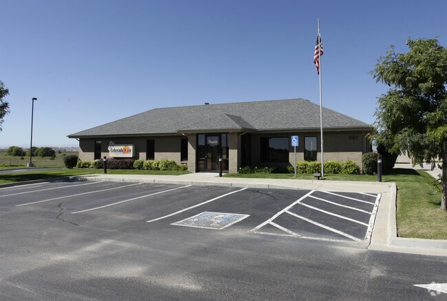
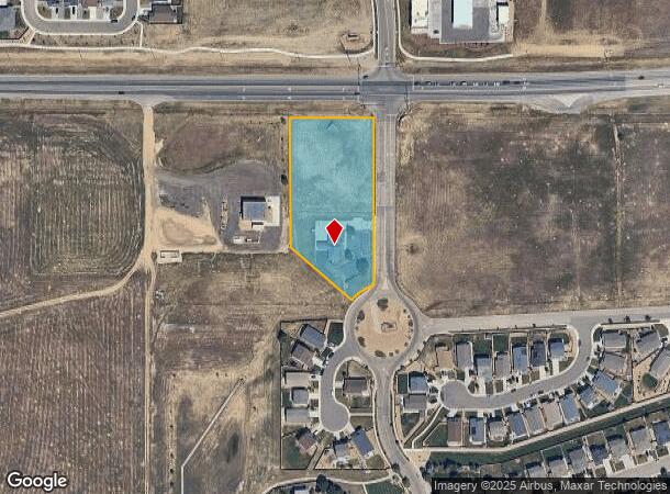
Property Record
801 Flying Circle Blvd, Dacono, CO 80514

Property Detail
801 Flying Circle Blvd
Greeley, CO
Sharpe Sub 1St Fg
R2055403
DAC 1SS L1 BLK1 SHARPE 1ST FG
Commercialacreage
Weld
X
Colorado
08123C2079E
1
2024
2.29 AC
2025
Greeley
002004
Denver
2,028 SF
NEARBY LISTINGS FOR SALE OR LEASE
DEMOGRAPHICS near 801 Flying Circle Blvd
1 mile
3 mile
5 mile
2024 Total Population
3,886
24,199
44,321
2029 Population
4,544
28,521
52,562
Pop Growth 2024-2029
+ 16.93%
+ 17.86%
+ 18.59%
Average Age
36
37
37
2024 Total Households
1,339
8,185
14,618
HH Growth 2024-2029
+ 17.25%
+ 18.22%
+ 18.94%
Median Household Inc
$94,432
$103,216
$112,245
Avg Household Size
2.80
2.90
3.00
2024 Avg HH Vehicles
2.00
2.00
3.00
Median Home Value
$376,504
$436,170
$464,997
Median Year Built
2010
2006
2008
Nearby Places
Map Layers
Map Styles
 Street
 Aerial
Transit
 Traffic
 Biking
Places
Listings with unknown addresses are not visible on the map
- Restaurants
- Banks
- Shops
- Fitness
- Groceries
PUBLIC TRANSPORTATION
AIRPORT
Denver International
Drive
Walk
Distance
Denver International
39 min
30.4 mi
Freight Ports
Tulsa Port Of Catoosa
Drive
Walk
Distance
Tulsa Port Of Catoosa
746 min
724.5 mi
SALE & LEASE HISTORY
LISTING DATE
SALE/LEASE

Jan 19, 2021
For Lease
Aug 22, 2018
For Sale
Nearby Properties
Address
Land Use
TOTAL SIZE
Lot Size
Zoning
Address
Land Use
TOTAL SIZE
Lot Size
Zoning
328,541 SF
19.97 AC
Address
Land Use
TOTAL SIZE
Lot Size
Zoning
207,946 SF
28.52 AC
Address
Land Use
TOTAL SIZE
Lot Size
Zoning
142,533 SF
16.51 AC
Address
Land Use
TOTAL SIZE
Lot Size
Zoning
69,399 SF
18.43 AC
Address
Land Use
TOTAL SIZE
Lot Size
Zoning
64,000 SF
10.77 AC
Address
Land Use
TOTAL SIZE
Lot Size
Zoning
73,074 SF
8.29 AC
Address
Land Use
TOTAL SIZE
Lot Size
Zoning
55,378 SF
9.60 AC
Address
Land Use
TOTAL SIZE
Lot Size
Zoning
109,252 SF
8.70 AC
Address
Land Use
TOTAL SIZE
Lot Size
Zoning
139,480 SF
6.76 AC
Address
Land Use
TOTAL SIZE
Lot Size
Zoning
40,980 SF
3.12 AC
Address
Land Use
TOTAL SIZE
Lot Size
Zoning
54,261 SF
7.50 AC
Address
Land Use
TOTAL SIZE
Lot Size
Zoning
45,909 SF
20.52 AC
Address
Land Use
TOTAL SIZE
Lot Size
Zoning
20,250 SF
4.07 AC
Address
Land Use
TOTAL SIZE
Lot Size
Zoning
51,010 SF
14.66 AC
Address
Land Use
TOTAL SIZE
Lot Size
Zoning
46,956 SF
1.08 AC
Address
Land Use
TOTAL SIZE
Lot Size
Zoning
41,870 SF
7.60 AC
Address
Land Use
TOTAL SIZE
Lot Size
Zoning
85,198 SF
5.96 AC
Address
Land Use
TOTAL SIZE
Lot Size
Zoning
50,046 SF
4.32 AC
Address
Land Use
TOTAL SIZE
Lot Size
Zoning
81,827 SF
6.27 AC
Address
Land Use
TOTAL SIZE
Lot Size
Zoning
36,375 SF
0.69 AC
Address
Land Use
TOTAL SIZE
Lot Size
Zoning
65,308 SF
2.38 AC
Address
Land Use
TOTAL SIZE
Lot Size
Zoning
6,530 SF
50.17 AC
Address
Land Use
TOTAL SIZE
Lot Size
Zoning
129,209 SF
19.35 AC
Address
Land Use
TOTAL SIZE
Lot Size
Zoning
56,766 SF
5.94 AC
Address
Land Use
TOTAL SIZE
Lot Size
Zoning
123,722 SF
10.94 AC
Address
Land Use
TOTAL SIZE
Lot Size
Zoning
43,919 SF
3.54 AC
Address
Land Use
TOTAL SIZE
Lot Size
Zoning
42,920 SF
3.24 AC
Address
Land Use
TOTAL SIZE
Lot Size
Zoning
42,288 SF
2 AC
Address
Land Use
TOTAL SIZE
Lot Size
Zoning
38,129 SF
2.73 AC
Address
Land Use
TOTAL SIZE
Lot Size
Zoning
36,891 SF
4.05 AC
The World's #1 Commercial Real Estate Marketplace
Connect with us
© 2026 CoStar Group
The information above has been obtained from sources believed reliable. While we do not doubt its accuracy we have not verified it and make no guarantee, warranty or representation about it. It is your responsibility to independently confirm its accuracy and completeness. Any projections, opinions, assumptions, or estimates used are for example only and do not represent the current or future performance of the property. The value of this transaction to you depends on tax and other factors which should be evaluated by your tax, financial, and legal advisors. You and your advisors should conduct a careful, independent investigation of the property to determine to your satisfaction the suitability of the property for your needs.