Property Record
801 Schoolhouse Rd, Haslet, TX 76052
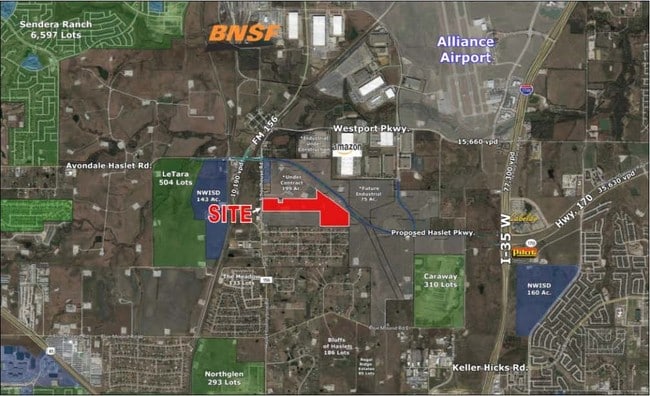
Property Detail
801 Schoolhouse Rd
Dallas-Fort Worth-Arlington, TX
M E P & P RR CO SURVEY #7 ABSTRACT 1126 TRACT 1C2A & 1C1B
06237428
TARRANT
Residentialacreage
Texas
AE The base floodplain where base flood elevations are provided. AE Zones are now used on new format FIRMs instead of A1-A30 Zones.
22.02 AC
0
Alliance
2025
Dallas/Ft Worth
114111
NEARBY LISTINGS FOR SALE OR LEASE
DEMOGRAPHICS near 801 Schoolhouse Rd
1 mile
3 mile
5 mile
2024 Total Population
852
30,395
147,991
2029 Population
946
33,049
159,947
Pop Growth 2024-2029
+ 11.03%
+ 8.73%
+ 8.08%
Average Age
43
35
35
2024 Total Households
319
10,022
47,569
HH Growth 2024-2029
+ 10.97%
+ 8.87%
+ 8.34%
Median Household Inc
$133,863
$131,238
$121,629
Avg Household Size
2.70
3.00
3.10
2024 Avg HH Vehicles
3.00
2.00
2.00
Median Home Value
$645,312
$421,606
$395,425
Median Year Built
2010
2010
2010
Nearby Places
Map Layers
Map Styles
 Street
 Aerial
Transit
 Traffic
 Biking
Places
Listings with unknown addresses are not visible on the map
- Restaurants
- Banks
- Shops
- Fitness
- Groceries
PUBLIC TRANSPORTATION
AIRPORT
Dallas-Fort Worth International
Drive
Walk
Distance
Dallas-Fort Worth International
36 min
25.6 mi
Dallas Love Field
Drive
Walk
Distance
Dallas Love Field
53 min
39.6 mi
Freight Ports
Port of Shreveport
Drive
Walk
Distance
Port of Shreveport
263 min
238.8 mi
SALE & LEASE HISTORY
LISTING DATE
SALE/LEASE

Aug 20, 2019
For Sale
Nearby Properties
Address
Land Use
TOTAL SIZE
Lot Size
Zoning
Address
Land Use
TOTAL SIZE
Lot Size
Zoning
348,270 SF
39.34 AC
Address
Land Use
TOTAL SIZE
Lot Size
Zoning
830,399 SF
11.02 AC
Address
Land Use
TOTAL SIZE
Lot Size
Zoning
564,806 SF
162.94 AC
Address
Land Use
TOTAL SIZE
Lot Size
Zoning
252,365 SF
20.53 AC
Address
Land Use
TOTAL SIZE
Lot Size
Zoning
681,942 SF
29.37 AC
Address
Land Use
TOTAL SIZE
Lot Size
Zoning
305,697 SF
42.24 AC
Address
Land Use
TOTAL SIZE
Lot Size
Zoning
471,408 SF
17.56 AC
Address
Land Use
TOTAL SIZE
Lot Size
Zoning
1,150,000 SF
117.10 AC
Address
Land Use
TOTAL SIZE
Lot Size
Zoning
1,141,133 SF
67.79 AC
Address
Land Use
TOTAL SIZE
Lot Size
Zoning
1,179,900 SF
73.58 AC
Address
Land Use
TOTAL SIZE
Lot Size
Zoning
504,000 SF
26.39 AC
Address
Land Use
TOTAL SIZE
Lot Size
Zoning
882,565 SF
56.65 AC
Address
Land Use
TOTAL SIZE
Lot Size
Zoning
1,001,600 SF
58.47 AC
Address
Land Use
TOTAL SIZE
Lot Size
Zoning
259,825 SF
14.95 AC
Address
Land Use
TOTAL SIZE
Lot Size
Zoning
1,140,525 SF
45.79 AC
Address
Land Use
TOTAL SIZE
Lot Size
Zoning
377,934 SF
16.02 AC
Address
Land Use
TOTAL SIZE
Lot Size
Zoning
807,229 SF
46.10 AC
Address
Land Use
TOTAL SIZE
Lot Size
Zoning
295,161 SF
257.32 AC
Address
Land Use
TOTAL SIZE
Lot Size
Zoning
279,612 SF
18.46 AC
Address
Land Use
TOTAL SIZE
Lot Size
Zoning
727,900 SF
40.15 AC
Address
Land Use
TOTAL SIZE
Lot Size
Zoning
707,940 SF
35.33 AC
Address
Land Use
TOTAL SIZE
Lot Size
Zoning
677,700 SF
42.17 AC
Address
Land Use
TOTAL SIZE
Lot Size
Zoning
267,831 SF
17.40 AC
Address
Land Use
TOTAL SIZE
Lot Size
Zoning
634,042 SF
35.88 AC
Address
Land Use
TOTAL SIZE
Lot Size
Zoning
546,000 SF
33.60 AC
Address
Land Use
TOTAL SIZE
Lot Size
Zoning
562,500 SF
29.64 AC
Address
Land Use
TOTAL SIZE
Lot Size
Zoning
731,548 SF
56.18 AC
Address
Land Use
TOTAL SIZE
Lot Size
Zoning
487,350 SF
26.34 AC
Address
Land Use
TOTAL SIZE
Lot Size
Zoning
436,589 SF
32.43 AC
Address
Land Use
TOTAL SIZE
Lot Size
Zoning
433,500 SF
27.58 AC
The World's #1 Commercial Real Estate Marketplace
Connect with us
© 2026 CoStar Group
The information above has been obtained from sources believed reliable. While we do not doubt its accuracy we have not verified it and make no guarantee, warranty or representation about it. It is your responsibility to independently confirm its accuracy and completeness. Any projections, opinions, assumptions, or estimates used are for example only and do not represent the current or future performance of the property. The value of this transaction to you depends on tax and other factors which should be evaluated by your tax, financial, and legal advisors. You and your advisors should conduct a careful, independent investigation of the property to determine to your satisfaction the suitability of the property for your needs.