Property Record
801 Staton Rd, Greenville, NC 27834
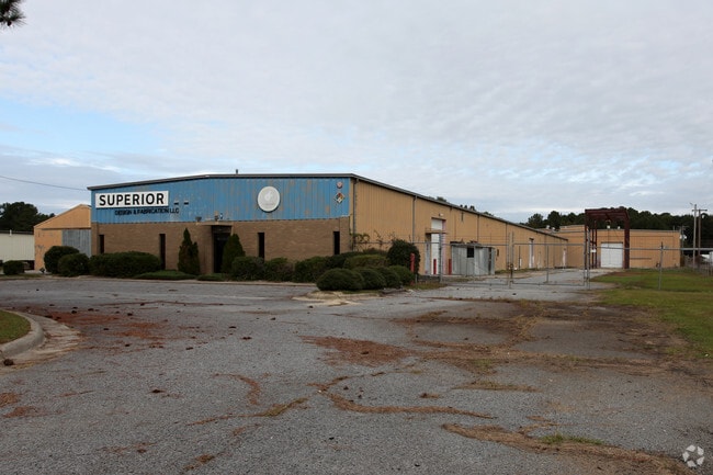

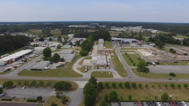
Property Detail
801 Staton Rd
033642
WORLD CAT
Manufacturinglight
PITT
IU
North Carolina
B and X Area of moderate flood hazard, usually the area between the limits of the 100-year and 500-year floods.
7.13 AC
2025
North Carolina Northeast Area
2025
Other Market Areas
000800
Greenville, NC
44,342 SF
NEARBY LISTINGS FOR SALE OR LEASE
DEMOGRAPHICS near 801 Staton Rd
1 mile
3 mile
5 mile
2025 Total Population
220
11,149
55,776
2030 Population
227
11,826
58,566
Pop Growth 2025-2030
+ 3.18%
+ 6.07%
+ 5.00%
Average Age
39
36
34
2025 Total Households
83
4,675
22,035
HH Growth 2025-2030
+ 2.41%
+ 6.18%
+ 5.70%
Median Household Inc
$60,577
$36,297
$43,696
Avg Household Size
2.60
2.10
2.10
2025 Avg HH Vehicles
2.00
2.00
2.00
Median Home Value
$139,655
$172,616
$183,744
Median Year Built
1995
1992
1988
Nearby Places
Map Layers
Map Styles
 Street
 Aerial
Layers
 Traffic
 Biking
Places
Listings with unknown addresses are not visible on the map
- Restaurants
- Banks
- Shops
- Fitness
- Groceries
PUBLIC TRANSPORTATION
AIRPORT
Pitt-Greenville
Drive
Walk
Distance
Pitt-Greenville
7 min
2.8 mi
SALE & LEASE HISTORY
LISTING DATE
SALE/LEASE

May 22, 2019
For Lease
Nearby Properties
Address
Land Use
TOTAL SIZE
Lot Size
Zoning
Address
Land Use
TOTAL SIZE
Lot Size
Zoning
1,585,097 SF
142.93 AC
IU
Address
Land Use
TOTAL SIZE
Lot Size
Zoning
275,664 SF
93.97 AC
R6
Address
Land Use
TOTAL SIZE
Lot Size
Zoning
339,992 SF
115.67 AC
CH
Address
Land Use
TOTAL SIZE
Lot Size
Zoning
506,392 SF
86.99 AC
IU
Address
Land Use
TOTAL SIZE
Lot Size
Zoning
253,726 SF
35.42 AC
PIU
Address
Land Use
TOTAL SIZE
Lot Size
Zoning
232,380 SF
666.85 AC
IU
Address
Land Use
TOTAL SIZE
Lot Size
Zoning
38,214 SF
40.39 AC
OR
Address
Land Use
TOTAL SIZE
Lot Size
Zoning
109,461 SF
1.89 AC
CD
Address
Land Use
TOTAL SIZE
Lot Size
Zoning
536,862 SF
38.22 AC
PIU
Address
Land Use
TOTAL SIZE
Lot Size
Zoning
267,434 SF
15.37 AC
PIU
Address
Land Use
TOTAL SIZE
Lot Size
Zoning
849,820 SF
77.56 AC
I
Address
Land Use
TOTAL SIZE
Lot Size
Zoning
442,815 SF
47.96 AC
I
Address
Land Use
TOTAL SIZE
Lot Size
Zoning
124,730 SF
16.75 AC
PIU
Address
Land Use
TOTAL SIZE
Lot Size
Zoning
169,247 SF
1.97 AC
CD
Address
Land Use
TOTAL SIZE
Lot Size
Zoning
8,890 SF
14.84 AC
R6
Address
Land Use
TOTAL SIZE
Lot Size
Zoning
42,296 SF
147.15 AC
RA20
Address
Land Use
TOTAL SIZE
Lot Size
Zoning
415,292 SF
68.94 AC
I
Address
Land Use
TOTAL SIZE
Lot Size
Zoning
8,649 SF
10.97 AC
R6
Address
Land Use
TOTAL SIZE
Lot Size
Zoning
90,632 SF
12.37 AC
IU
Address
Land Use
TOTAL SIZE
Lot Size
Zoning
233,534 SF
24.51 AC
IU
Address
Land Use
TOTAL SIZE
Lot Size
Zoning
53,410 SF
4 AC
OR
Address
Land Use
TOTAL SIZE
Lot Size
Zoning
15,376 SF
8.13 AC
CD
Address
Land Use
TOTAL SIZE
Lot Size
Zoning
36,225 SF
26.22 AC
OR
Address
Land Use
TOTAL SIZE
Lot Size
Zoning
35,067 SF
7.68 AC
CH
Address
Land Use
TOTAL SIZE
Lot Size
Zoning
32,077 SF
10.85 AC
CH
Address
Land Use
TOTAL SIZE
Lot Size
Zoning
338,400 SF
20.49 AC
I
Address
Land Use
TOTAL SIZE
Lot Size
Zoning
96,614 SF
I
Address
Land Use
TOTAL SIZE
Lot Size
Zoning
59,624 SF
7.75 AC
CH
Address
Land Use
TOTAL SIZE
Lot Size
Zoning
75,357 SF
26.19 AC
RA20
Address
Land Use
TOTAL SIZE
Lot Size
Zoning
80,001 SF
1.63 AC
R6
The World's #1 Commercial Real Estate Marketplace
Connect with us
© 2026 CoStar Group
The information above has been obtained from sources believed reliable. While we do not doubt its accuracy we have not verified it and make no guarantee, warranty or representation about it. It is your responsibility to independently confirm its accuracy and completeness. Any projections, opinions, assumptions, or estimates used are for example only and do not represent the current or future performance of the property. The value of this transaction to you depends on tax and other factors which should be evaluated by your tax, financial, and legal advisors. You and your advisors should conduct a careful, independent investigation of the property to determine to your satisfaction the suitability of the property for your needs.