Property Record
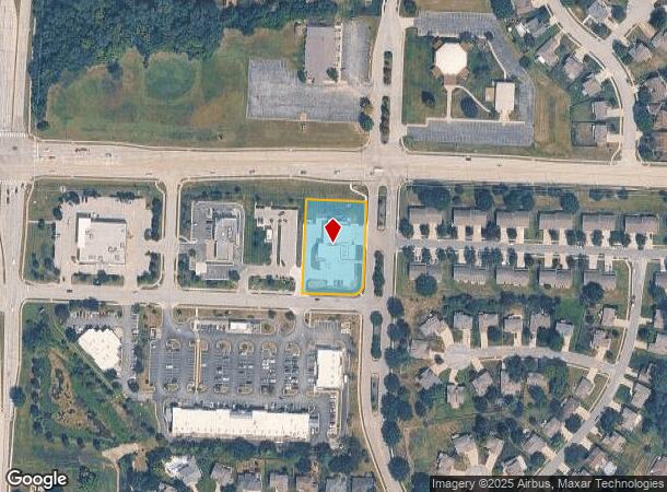
801 Sw State Route 150, Lees Summit, MO 64082
NEARBY LISTINGS FOR SALE OR LEASE
Property Detail
801 Sw State Route 150
Kansas City, MO-KS
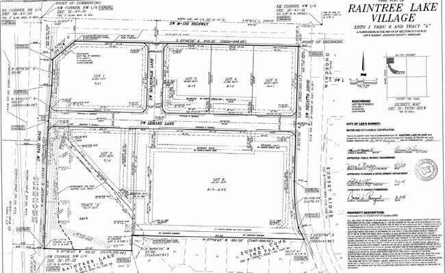
Raintree Lake Village
70-920-16-01-00-0-00-000
RAINTREE LAKE VILLAGE LOTS 1-6 & TR A---LOT 5
Policefirecivildefense
Jackson
X
Missouri
29095C0532G
1-6,5
2021
1.01 AC
2025
Southeast Jackson County
018101
Kansas City
24,567 SF
DEMOGRAPHICS near 801 Sw State Route 150
1 Mile
3 Mile
5 Mile
2024 Total Population
7,852
27,135
71,387
2029 Population
7,954
27,534
72,345
Pop Growth 2024-2029
+ 1.30%
+ 1.47%
+ 1.34%
Average Age
39
38
40
2024 Total Households
2,797
9,390
26,993
HH Growth 2024-2029
+ 1.25%
+ 1.61%
+ 1.31%
Median Household Inc
$127,143
$121,409
$99,955
Avg Household Size
2.80
2.90
2.60
2024 Avg HH Vehicles
2.00
2.00
2.00
Median Home Value
$325,000
$325,793
$286,085
Median Year Built
2003
2001
1993
Nearby Places
Map Layers
Map Styles
 Street
 Aerial
- Restaurants
- Banks
- Shops
- Fitness
- Groceries
PUBLIC TRANSPORTATION
COMMUTER RAIL
DRIVE
WALK
Distance
11 min
5.5 mi
AIRPORT
Kansas City International
DRIVE
WALK
Distance
Kansas City International
63 min
45.9 mi
SALE & LEASE HISTORY
LISTING DATE
SALE/LEASE

Jul 10, 2017
For Sale
Aug 11, 2017
For Sale
Nearby Properties
Address
Land Use
TOTAL SIZE
Lot Size
Zoning
Address
Land Use
TOTAL SIZE
Lot Size
Zoning
249,821 SF
87.90 AC
Address
Land Use
TOTAL SIZE
Lot Size
Zoning
563,000 SF
40.34 AC
Address
Land Use
TOTAL SIZE
Lot Size
Zoning
281,235 SF
70.15 AC
Address
Land Use
TOTAL SIZE
Lot Size
Zoning
200,526 SF
Address
Land Use
TOTAL SIZE
Lot Size
Zoning
18,509 SF
20.39 AC
Address
Land Use
TOTAL SIZE
Lot Size
Zoning
143,335 SF
Address
Land Use
TOTAL SIZE
Lot Size
Zoning
155,194 SF
21.03 AC
Address
Land Use
TOTAL SIZE
Lot Size
Zoning
36,744 SF
20.20 AC
Address
Land Use
TOTAL SIZE
Lot Size
Zoning
140,194 SF
29.50 AC
Address
Land Use
TOTAL SIZE
Lot Size
Zoning
74,096 SF
20.35 AC
Address
Land Use
TOTAL SIZE
Lot Size
Zoning
74,741 SF
20 AC
Address
Land Use
TOTAL SIZE
Lot Size
Zoning
11,599 SF
9.86 AC
Address
Land Use
TOTAL SIZE
Lot Size
Zoning
89,962 SF
10.37 AC
Address
Land Use
TOTAL SIZE
Lot Size
Zoning
171,779 SF
11.42 AC
Address
Land Use
TOTAL SIZE
Lot Size
Zoning
33,063 SF
17.56 AC
Address
Land Use
TOTAL SIZE
Lot Size
Zoning
11,203 SF
1.27 AC
Address
Land Use
TOTAL SIZE
Lot Size
Zoning
Address
Land Use
TOTAL SIZE
Lot Size
Zoning
225,792 SF
9.59 AC
Address
Land Use
TOTAL SIZE
Lot Size
Zoning
29,336 SF
Address
Land Use
TOTAL SIZE
Lot Size
Zoning
61,263 SF
Address
Land Use
TOTAL SIZE
Lot Size
Zoning
34,840 SF
9.81 AC
Address
Land Use
TOTAL SIZE
Lot Size
Zoning
7,674 SF
Address
Land Use
TOTAL SIZE
Lot Size
Zoning
Address
Land Use
TOTAL SIZE
Lot Size
Zoning
Address
Land Use
TOTAL SIZE
Lot Size
Zoning
19,632 SF
2.42 AC
Address
Land Use
TOTAL SIZE
Lot Size
Zoning
15,295 SF
Address
Land Use
TOTAL SIZE
Lot Size
Zoning
48,971 SF
16.08 AC
Address
Land Use
TOTAL SIZE
Lot Size
Zoning
558 SF
156.41 AC
Address
Land Use
TOTAL SIZE
Lot Size
Zoning
33,406 SF
5.69 AC
The World's #1 Commercial Real Estate Marketplace
Connect with us
© 2025 CoStar Group
The information above has been obtained from sources believed reliable. While we do not doubt its accuracy we have not verified it and make no guarantee, warranty or representation about it. It is your responsibility to independently confirm its accuracy and completeness. Any projections, opinions, assumptions, or estimates used are for example only and do not represent the current or future performance of the property. The value of this transaction to you depends on tax and other factors which should be evaluated by your tax, financial, and legal advisors. You and your advisors should conduct a careful, independent investigation of the property to determine to your satisfaction the suitability of the property for your needs.