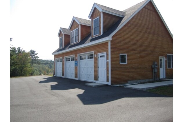
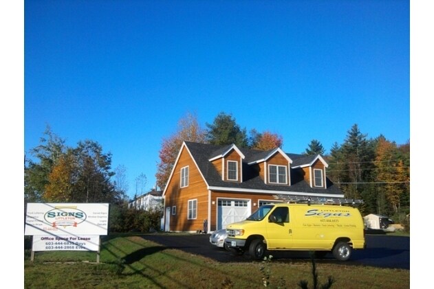
Property Record
801 Union St, Littleton, NH 03561

NEARBY LISTINGS FOR SALE OR LEASE
-
-
View all Littleton listings for sale on LoopNet.com
Property Detail
801 Union St
Commercialofficeresidentialmixeduse
Grafton
X
New Hampshire
33007C1050D
0.85 AC
2024
Other Market Areas
2024
Claremont-Lebanon, NH-VT
960101
LTLN-000069-000014
1,440 SF
DEMOGRAPHICS near 801 Union St
1 Mile
3 Mile
5 Mile
2024 Total Population
1,731
5,704
8,503
2029 Population
1,819
6,004
8,930
Pop Growth 2024-2029
+ 5.08%
+ 5.26%
+ 5.02%
Average Age
44
45
46
2024 Total Households
805
2,705
3,932
HH Growth 2024-2029
+ 4.72%
+ 4.88%
+ 4.68%
Median Household Inc
$29,685
$46,023
$52,885
Avg Household Size
2.10
2.10
2.10
2024 Avg HH Vehicles
1.00
1.00
1.00
Median Home Value
$164,746
$191,408
$204,281
Median Year Built
1953
1959
1963
Nearby Places
Map Layers
Map Styles
 Street
 Aerial
- Restaurants
- Banks
- Shops
- Fitness
- Groceries
Nearby Properties
Address
Land Use
TOTAL SIZE
Lot Size
Zoning
Address
Land Use
TOTAL SIZE
Lot Size
Zoning
0.92 AC
D-1
Address
Land Use
TOTAL SIZE
Lot Size
Zoning
110,483 SF
3.70 AC
R-1
Address
Land Use
TOTAL SIZE
Lot Size
Zoning
96,456 SF
19.30 AC
C-1
Address
Land Use
TOTAL SIZE
Lot Size
Zoning
20,273 SF
18 AC
D-2
Address
Land Use
TOTAL SIZE
Lot Size
Zoning
55,196 SF
9 AC
C-1
Address
Land Use
TOTAL SIZE
Lot Size
Zoning
118,756 SF
23.30 AC
I
Address
Land Use
TOTAL SIZE
Lot Size
Zoning
58,967 SF
5.40 AC
C-1
Address
Land Use
TOTAL SIZE
Lot Size
Zoning
62,400 SF
6.30 AC
C-1
Address
Land Use
TOTAL SIZE
Lot Size
Zoning
4,800 SF
29.34 AC
R-1
Address
Land Use
TOTAL SIZE
Lot Size
Zoning
38,764 SF
7.80 AC
C-1
Address
Land Use
TOTAL SIZE
Lot Size
Zoning
4.50 AC
R-2
Address
Land Use
TOTAL SIZE
Lot Size
Zoning
29,496 SF
75 AC
R-1
Address
Land Use
TOTAL SIZE
Lot Size
Zoning
34,684 SF
1.90 AC
C-1
Address
Land Use
TOTAL SIZE
Lot Size
Zoning
1,354 SF
46 AC
D-2
Address
Land Use
TOTAL SIZE
Lot Size
Zoning
40,973 SF
4.56 AC
R-1
Address
Land Use
TOTAL SIZE
Lot Size
Zoning
8,450 SF
8.35 AC
C-1
Address
Land Use
TOTAL SIZE
Lot Size
Zoning
4,860 SF
3.96 AC
C-2
Address
Land Use
TOTAL SIZE
Lot Size
Zoning
23,659 SF
0.84 AC
C-1
Address
Land Use
TOTAL SIZE
Lot Size
Zoning
79,282 SF
16.26 AC
I
Address
Land Use
TOTAL SIZE
Lot Size
Zoning
16,508 SF
17.03 AC
R
Address
Land Use
TOTAL SIZE
Lot Size
Zoning
13,799 SF
1.38 AC
C-4
Address
Land Use
TOTAL SIZE
Lot Size
Zoning
35,574 SF
4.40 AC
I
Address
Land Use
TOTAL SIZE
Lot Size
Zoning
3,476 SF
233.48 AC
D-2
Address
Land Use
TOTAL SIZE
Lot Size
Zoning
2,798 SF
3.20 AC
R-1
Address
Land Use
TOTAL SIZE
Lot Size
Zoning
96,494 SF
12.90 AC
I
Address
Land Use
TOTAL SIZE
Lot Size
Zoning
12,608 SF
2.40 AC
C-4
Address
Land Use
TOTAL SIZE
Lot Size
Zoning
21,201 SF
0.30 AC
C-1
Address
Land Use
TOTAL SIZE
Lot Size
Zoning
7,557 SF
182.18 AC
D-2
Address
Land Use
TOTAL SIZE
Lot Size
Zoning
26,566 SF
9.20 AC
C-4
Address
Land Use
TOTAL SIZE
Lot Size
Zoning
37,100 SF
2.16 AC
R-1
The World's #1 Commercial Real Estate Marketplace
Connect with us
© 2025 CoStar Group
The information above has been obtained from sources believed reliable. While we do not doubt its accuracy we have not verified it and make no guarantee, warranty or representation about it. It is your responsibility to independently confirm its accuracy and completeness. Any projections, opinions, assumptions, or estimates used are for example only and do not represent the current or future performance of the property. The value of this transaction to you depends on tax and other factors which should be evaluated by your tax, financial, and legal advisors. You and your advisors should conduct a careful, independent investigation of the property to determine to your satisfaction the suitability of the property for your needs.