Property Record
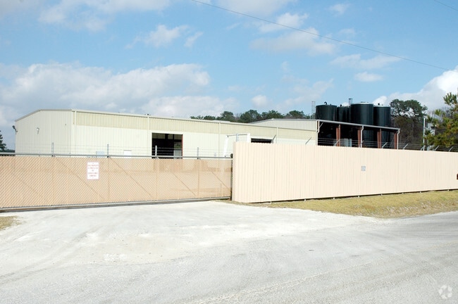
8010 Needlepoint Rd, Baytown, TX 77521

Property Detail
8010 Needlepoint Rd
0401680000024
TR 32 ABST 4 W BLOODGOOD
Warehouse
HARRIS
AE The base floodplain where base flood elevations are provided. AE Zones are now used on new format FIRMs instead of A1-A30 Zones.
Texas
2024
5 AC
2025
East-Southeast Far
253201
Houston
17,184 SF
Houston-Pasadena-The Woodlands, TX
NEARBY LISTINGS FOR SALE OR LEASE
DEMOGRAPHICS near 8010 Needlepoint Rd
1 mile
3 mile
5 mile
2025 Total Population
1,824
25,968
84,142
2030 Population
1,967
29,400
92,528
Pop Growth 2025-2030
+ 7.84%
+ 13.22%
+ 9.97%
Average Age
38
36
36
2025 Total Households
566
8,338
28,657
HH Growth 2025-2030
+ 8.13%
+ 13.37%
+ 9.90%
Median Household Inc
$130,980
$99,298
$80,710
Avg Household Size
3.10
3.10
2.90
2025 Avg HH Vehicles
2.00
2.00
2.00
Median Home Value
$331,899
$264,347
$254,515
Median Year Built
2002
2004
2000
Nearby Places
Map Layers
Map Styles
 Street
 Aerial
Transit
 Traffic
 Biking
Places
Listings with unknown addresses are not visible on the map
- Restaurants
- Banks
- Shops
- Fitness
- Groceries
PUBLIC TRANSPORTATION
AIRPORT
William P Hobby
Drive
Walk
Distance
William P Hobby
48 min
32.5 mi
George Bush Intcntl/Houston
Drive
Walk
Distance
George Bush Intcntl/Houston
45 min
36.7 mi
Freight Ports
Port of Houston
Drive
Walk
Distance
Port of Houston
35 min
24.5 mi
Nearby Properties
Address
Land Use
TOTAL SIZE
Lot Size
Zoning
Address
Land Use
TOTAL SIZE
Lot Size
Zoning
0.58 AC
Address
Land Use
TOTAL SIZE
Lot Size
Zoning
63,224 SF
738.31 AC
Address
Land Use
TOTAL SIZE
Lot Size
Zoning
738.47 AC
Address
Land Use
TOTAL SIZE
Lot Size
Zoning
463.62 AC
Address
Land Use
TOTAL SIZE
Lot Size
Zoning
738.31 AC
Address
Land Use
TOTAL SIZE
Lot Size
Zoning
Address
Land Use
TOTAL SIZE
Lot Size
Zoning
Address
Land Use
TOTAL SIZE
Lot Size
Zoning
738.47 AC
Address
Land Use
TOTAL SIZE
Lot Size
Zoning
504,680 SF
29.61 AC
Address
Land Use
TOTAL SIZE
Lot Size
Zoning
251,498 SF
16.36 AC
Address
Land Use
TOTAL SIZE
Lot Size
Zoning
133,873 SF
12.26 AC
Address
Land Use
TOTAL SIZE
Lot Size
Zoning
22,375 SF
12.13 AC
Address
Land Use
TOTAL SIZE
Lot Size
Zoning
58,493 SF
18.49 AC
Address
Land Use
TOTAL SIZE
Lot Size
Zoning
59.21 AC
Address
Land Use
TOTAL SIZE
Lot Size
Zoning
738.47 AC
Address
Land Use
TOTAL SIZE
Lot Size
Zoning
103,107 SF
15.56 AC
Address
Land Use
TOTAL SIZE
Lot Size
Zoning
187,383 SF
18.95 AC
Address
Land Use
TOTAL SIZE
Lot Size
Zoning
224,472 SF
12 AC
Address
Land Use
TOTAL SIZE
Lot Size
Zoning
39,869 SF
7.97 AC
Address
Land Use
TOTAL SIZE
Lot Size
Zoning
44,652 SF
12.33 AC
Address
Land Use
TOTAL SIZE
Lot Size
Zoning
139,880 SF
2.97 AC
Address
Land Use
TOTAL SIZE
Lot Size
Zoning
111,906 SF
15.67 AC
Address
Land Use
TOTAL SIZE
Lot Size
Zoning
59,580 SF
4.10 AC
Address
Land Use
TOTAL SIZE
Lot Size
Zoning
76,536 SF
2.72 AC
Address
Land Use
TOTAL SIZE
Lot Size
Zoning
45.60 AC
Address
Land Use
TOTAL SIZE
Lot Size
Zoning
49,600 SF
5.20 AC
Address
Land Use
TOTAL SIZE
Lot Size
Zoning
79,168 SF
124.52 AC
Address
Land Use
TOTAL SIZE
Lot Size
Zoning
79,825 SF
5.95 AC
Address
Land Use
TOTAL SIZE
Lot Size
Zoning
6,771 SF
28.08 AC
Address
Land Use
TOTAL SIZE
Lot Size
Zoning
60.91 AC
The World's #1 Commercial Real Estate Marketplace
Connect with us
© 2026 CoStar Group
The information above has been obtained from sources believed reliable. While we do not doubt its accuracy we have not verified it and make no guarantee, warranty or representation about it. It is your responsibility to independently confirm its accuracy and completeness. Any projections, opinions, assumptions, or estimates used are for example only and do not represent the current or future performance of the property. The value of this transaction to you depends on tax and other factors which should be evaluated by your tax, financial, and legal advisors. You and your advisors should conduct a careful, independent investigation of the property to determine to your satisfaction the suitability of the property for your needs.