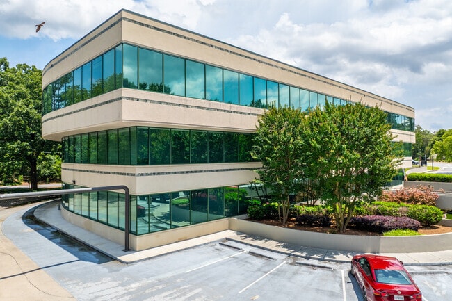
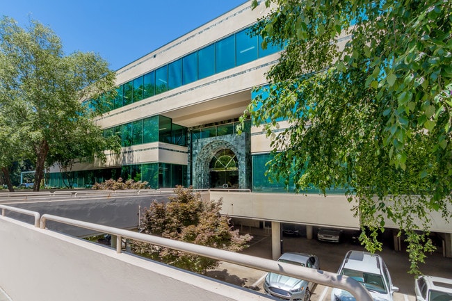
Property Record
8010 Roswell Rd, Atlanta, GA 30350


Current Lease Availabilities
NEARBY LISTINGS FOR SALE OR LEASE
Property Detail
8010 Roswell Rd
17-0024-LL-088-2
Devonwood
Officebuilding
Fulton
X
Georgia
13089C0005K
24
2024
3.23 AC
2025
Central Perimeter
010218
Atlanta
138,909 SF
Atlanta-Sandy Springs-Roswell, GA
DEMOGRAPHICS near 8010 Roswell Rd
1 Mile
3 Mile
5 Mile
2024 Total Population
12,889
76,476
222,587
2029 Population
12,919
77,048
225,246
Pop Growth 2024-2029
+ 0.23%
+ 0.75%
+ 1.19%
Average Age
37
39
40
2024 Total Households
6,569
33,245
93,730
HH Growth 2024-2029
+ 0.20%
+ 0.83%
+ 1.31%
Median Household Inc
$68,252
$98,506
$105,361
Avg Household Size
1.90
2.20
2.30
2024 Avg HH Vehicles
1.00
2.00
2.00
Median Home Value
$534,522
$562,866
$534,634
Median Year Built
1986
1984
1986
Nearby Places
Map Layers
Map Styles
 Street
 Aerial
- Restaurants
- Banks
- Shops
- Fitness
- Groceries
PUBLIC TRANSPORTATION
AIRPORT
Hartsfield - Jackson Atlanta International
DRIVE
WALK
Distance
Hartsfield - Jackson Atlanta International
40 min
28.2 mi
Freight Ports
Georgia Ports - Savannah
DRIVE
WALK
Distance
Georgia Ports - Savannah
303 min
267.5 mi
Nearby Properties
Address
Land Use
TOTAL SIZE
Lot Size
Zoning
Address
Land Use
TOTAL SIZE
Lot Size
Zoning
543,090 SF
5.51 AC
R2
Address
Land Use
TOTAL SIZE
Lot Size
Zoning
485,132 SF
37.90 AC
OI
Address
Land Use
TOTAL SIZE
Lot Size
Zoning
295,885 SF
3.50 AC
X
Address
Land Use
TOTAL SIZE
Lot Size
Zoning
258,909 SF
19.01 AC
X
Address
Land Use
TOTAL SIZE
Lot Size
Zoning
12,342,500 SF
125.51 AC
AC
Address
Land Use
TOTAL SIZE
Lot Size
Zoning
1,088,359 SF
7.07 AC
OIC
Address
Land Use
TOTAL SIZE
Lot Size
Zoning
4,555,620 SF
12.41 AC
OI
Address
Land Use
TOTAL SIZE
Lot Size
Zoning
347,179 SF
18.24 AC
X
Address
Land Use
TOTAL SIZE
Lot Size
Zoning
828,002 SF
12.04 AC
R2
Address
Land Use
TOTAL SIZE
Lot Size
Zoning
732,923 SF
2.77 AC
OIC
Address
Land Use
TOTAL SIZE
Lot Size
Zoning
1,119,177 SF
5.21 AC
OIC
Address
Land Use
TOTAL SIZE
Lot Size
Zoning
292,537 SF
10.50 AC
ACOND
Address
Land Use
TOTAL SIZE
Lot Size
Zoning
7,258,269 SF
38.75 AC
AC
Address
Land Use
TOTAL SIZE
Lot Size
Zoning
732,896 SF
3.96 AC
OIC
Address
Land Use
TOTAL SIZE
Lot Size
Zoning
1,909,285 SF
22.39 AC
OI
Address
Land Use
TOTAL SIZE
Lot Size
Zoning
10,614,240 SF
24.05 AC
A
Address
Land Use
TOTAL SIZE
Lot Size
Zoning
892,367 SF
3.37 AC
OIC
Address
Land Use
TOTAL SIZE
Lot Size
Zoning
234,555 SF
12.18 AC
RM-HD
Address
Land Use
TOTAL SIZE
Lot Size
Zoning
8,014,916 SF
28.58 AC
R4
Address
Land Use
TOTAL SIZE
Lot Size
Zoning
10,866,920 SF
31.48 AC
AC
Address
Land Use
TOTAL SIZE
Lot Size
Zoning
3,714,740 SF
45.91 AC
A1
Address
Land Use
TOTAL SIZE
Lot Size
Zoning
647,376 SF
22.43 AC
AC
Address
Land Use
TOTAL SIZE
Lot Size
Zoning
2,461,880 SF
35.44 AC
OIC
Address
Land Use
TOTAL SIZE
Lot Size
Zoning
9,550,520 SF
25.59 AC
AC
Address
Land Use
TOTAL SIZE
Lot Size
Zoning
351,099 SF
17.26 AC
ALC
Address
Land Use
TOTAL SIZE
Lot Size
Zoning
287,388 SF
44.90 AC
ACOND
Address
Land Use
TOTAL SIZE
Lot Size
Zoning
305,733 SF
10.93 AC
OIC
Address
Land Use
TOTAL SIZE
Lot Size
Zoning
4,124,136 SF
19.85 AC
AC
Address
Land Use
TOTAL SIZE
Lot Size
Zoning
269,200 SF
18.70 AC
A0
Address
Land Use
TOTAL SIZE
Lot Size
Zoning
1,957,333 SF
19.86 AC
AC
The World's #1 Commercial Real Estate Marketplace
Connect with us
© 2026 CoStar Group
The information above has been obtained from sources believed reliable. While we do not doubt its accuracy we have not verified it and make no guarantee, warranty or representation about it. It is your responsibility to independently confirm its accuracy and completeness. Any projections, opinions, assumptions, or estimates used are for example only and do not represent the current or future performance of the property. The value of this transaction to you depends on tax and other factors which should be evaluated by your tax, financial, and legal advisors. You and your advisors should conduct a careful, independent investigation of the property to determine to your satisfaction the suitability of the property for your needs.