Property Record
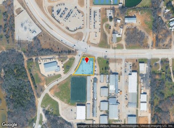
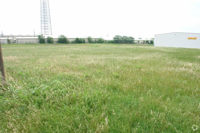
8010 Teasley Ln, Denton, TX 76210


Property Detail
8010 Teasley Ln
Dallas-Fort Worth-Arlington, TX
Denton Creek Business Park Ph 1
R745126
DENTON CREEK BUSINESS PARK PH 1 BLK A LOT 1R
Commercialnec
Denton
X
Texas
48121C0388H
1r
2024
0.85 AC
2025
Denton
021410
Dallas/Ft Worth
6,300 SF
NEARBY LISTINGS FOR SALE OR LEASE
DEMOGRAPHICS near 8010 Teasley Ln
1 mile
3 mile
5 mile
2024 Total Population
5,112
55,984
145,809
2029 Population
6,116
67,010
175,424
Pop Growth 2024-2029
+ 19.64%
+ 19.69%
+ 20.31%
Average Age
36
39
39
2024 Total Households
1,681
18,907
51,900
HH Growth 2024-2029
+ 20.23%
+ 20.30%
+ 20.93%
Median Household Inc
$74,055
$120,032
$105,014
Avg Household Size
3.00
2.90
2.80
2024 Avg HH Vehicles
2.00
2.00
2.00
Median Home Value
$248,704
$349,379
$369,692
Median Year Built
2003
2002
2001
Nearby Places
Map Layers
Map Styles
 Street
 Aerial
Transit
 Traffic
 Biking
Places
Listings with unknown addresses are not visible on the map
- Restaurants
- Banks
- Shops
- Fitness
- Groceries
PUBLIC TRANSPORTATION
COMMUTER RAIL
Drive
Walk
Distance
10 min
4.6 mi
Drive
Walk
Distance
10 min
4.6 mi
AIRPORT
Dallas-Fort Worth International
Drive
Walk
Distance
Dallas-Fort Worth International
31 min
22.2 mi
Dallas Love Field
Drive
Walk
Distance
Dallas Love Field
43 min
31.2 mi
Nearby Properties
Address
Land Use
TOTAL SIZE
Lot Size
Zoning
Address
Land Use
TOTAL SIZE
Lot Size
Zoning
386,056 SF
81.56 AC
Address
Land Use
TOTAL SIZE
Lot Size
Zoning
360,000 SF
24.34 AC
Address
Land Use
TOTAL SIZE
Lot Size
Zoning
246,535 SF
53.67 AC
Address
Land Use
TOTAL SIZE
Lot Size
Zoning
208,582 SF
8.58 AC
Address
Land Use
TOTAL SIZE
Lot Size
Zoning
191,512 SF
8.04 AC
Address
Land Use
TOTAL SIZE
Lot Size
Zoning
178,272 SF
10.25 AC
Address
Land Use
TOTAL SIZE
Lot Size
Zoning
202,197 SF
39.88 AC
Address
Land Use
TOTAL SIZE
Lot Size
Zoning
264,138 SF
38.41 AC
Address
Land Use
TOTAL SIZE
Lot Size
Zoning
185,592 SF
14.38 AC
Address
Land Use
TOTAL SIZE
Lot Size
Zoning
77,887 SF
20.59 AC
Address
Land Use
TOTAL SIZE
Lot Size
Zoning
150,104 SF
11.58 AC
Address
Land Use
TOTAL SIZE
Lot Size
Zoning
2,528 SF
1.57 AC
Address
Land Use
TOTAL SIZE
Lot Size
Zoning
157,100 SF
10.44 AC
Address
Land Use
TOTAL SIZE
Lot Size
Zoning
6,650 SF
80.50 AC
Address
Land Use
TOTAL SIZE
Lot Size
Zoning
256,043 SF
17.48 AC
Address
Land Use
TOTAL SIZE
Lot Size
Zoning
158,279 SF
53.75 AC
Address
Land Use
TOTAL SIZE
Lot Size
Zoning
116,516 SF
4.20 AC
Address
Land Use
TOTAL SIZE
Lot Size
Zoning
65,556 SF
12.35 AC
Address
Land Use
TOTAL SIZE
Lot Size
Zoning
50,905 SF
5.61 AC
Address
Land Use
TOTAL SIZE
Lot Size
Zoning
80,849 SF
4.05 AC
Address
Land Use
TOTAL SIZE
Lot Size
Zoning
90,216 SF
2.76 AC
Address
Land Use
TOTAL SIZE
Lot Size
Zoning
80,935 SF
2.60 AC
Address
Land Use
TOTAL SIZE
Lot Size
Zoning
108,867 SF
4.81 AC
Address
Land Use
TOTAL SIZE
Lot Size
Zoning
34,592 SF
49.57 AC
Address
Land Use
TOTAL SIZE
Lot Size
Zoning
1,635 SF
45.47 AC
Address
Land Use
TOTAL SIZE
Lot Size
Zoning
72,184 SF
11.39 AC
Address
Land Use
TOTAL SIZE
Lot Size
Zoning
84,377 SF
2.96 AC
Address
Land Use
TOTAL SIZE
Lot Size
Zoning
96,925 SF
2.50 AC
Address
Land Use
TOTAL SIZE
Lot Size
Zoning
32,200 SF
5 AC
Address
Land Use
TOTAL SIZE
Lot Size
Zoning
37,915 SF
4.08 AC
The World's #1 Commercial Real Estate Marketplace
Connect with us
© 2026 CoStar Group
The information above has been obtained from sources believed reliable. While we do not doubt its accuracy we have not verified it and make no guarantee, warranty or representation about it. It is your responsibility to independently confirm its accuracy and completeness. Any projections, opinions, assumptions, or estimates used are for example only and do not represent the current or future performance of the property. The value of this transaction to you depends on tax and other factors which should be evaluated by your tax, financial, and legal advisors. You and your advisors should conduct a careful, independent investigation of the property to determine to your satisfaction the suitability of the property for your needs.