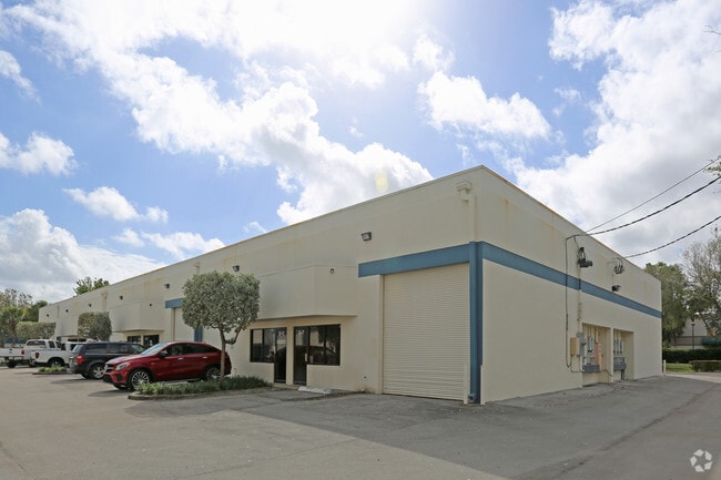
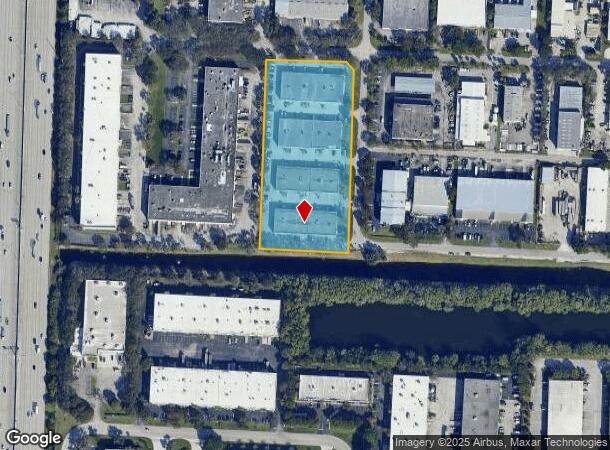
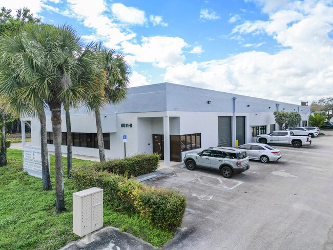
Property Record
8011 Monetary Dr, Riviera Beach, FL 33404
Current Lease Availabilities
NEARBY LISTINGS FOR SALE OR LEASE
Property Detail
8011 Monetary Dr
West Palm Beach-Boca Raton-Delray Beach, FL
Central Ind Park
00-43-42-19-10-000-0040
CENTRAL IND PARK NORTH~ LTS 4 THRU 7
Warehouse
Palm Beach
X
Florida
12099C0386F
4
2024
4.67 AC
2025
Central Palm Bch Area
001004
South Florida
77,828 SF
DEMOGRAPHICS near 8011 Monetary Dr
1 mile
3 mile
5 mile
2024 Total Population
13,614
93,565
200,805
2029 Population
14,281
97,773
210,799
Pop Growth 2024-2029
+ 4.90%
+ 4.50%
+ 4.98%
Average Age
37
40
43
2024 Total Households
4,893
35,550
83,706
HH Growth 2024-2029
+ 4.23%
+ 3.89%
+ 4.67%
Median Household Inc
$62,528
$62,935
$68,431
Avg Household Size
2.70
2.50
2.30
2024 Avg HH Vehicles
2.00
2.00
2.00
Median Home Value
$242,444
$303,817
$360,536
Median Year Built
1996
1983
1985
Nearby Places
Map Layers
Map Styles
 Street
 Aerial
Transit
 Traffic
 Biking
Places
Listings with unknown addresses are not visible on the map
- Restaurants
- Banks
- Shops
- Fitness
- Groceries
PUBLIC TRANSPORTATION
COMMUTER RAIL
Mangonia Park (Tri-County Commuter - South Florida Regional Transportation Authority (Tri-Rail))
Drive
Walk
Distance
Mangonia Park (Tri-County Commuter - South Florida Regional Transportation Authority (Tri-Rail))
10 min
4.2 mi
West Palm Beach (Tri-County Commuter - South Florida Regional Transportation Authority (Tri-Rail))
Drive
Walk
Distance
West Palm Beach (Tri-County Commuter - South Florida Regional Transportation Authority (Tri-Rail))
14 min
8.7 mi
AIRPORT
Palm Beach International
Drive
Walk
Distance
Palm Beach International
19 min
11.4 mi
Nearby Properties
Address
Land Use
TOTAL SIZE
Lot Size
Zoning
Address
Land Use
TOTAL SIZE
Lot Size
Zoning
1,778,741 SF
69.19 AC
CF
Address
Land Use
TOTAL SIZE
Lot Size
Zoning
650,167 SF
27.64 AC
PCD
Address
Land Use
TOTAL SIZE
Lot Size
Zoning
524,755 SF
21.34 AC
RH
Address
Land Use
TOTAL SIZE
Lot Size
Zoning
390,319 SF
44.34 AC
PCD
Address
Land Use
TOTAL SIZE
Lot Size
Zoning
411,080 SF
7.59 AC
CPD
Address
Land Use
TOTAL SIZE
Lot Size
Zoning
292,706 SF
30.75 AC
RPD
Address
Land Use
TOTAL SIZE
Lot Size
Zoning
416,171 SF
19.24 AC
R-PUD
Address
Land Use
TOTAL SIZE
Lot Size
Zoning
368,320 SF
23.07 AC
CLIC
Address
Land Use
TOTAL SIZE
Lot Size
Zoning
224,212 SF
141.33 AC
CSPD
Address
Land Use
TOTAL SIZE
Lot Size
Zoning
406,434 SF
40.60 AC
P/I
Address
Land Use
TOTAL SIZE
Lot Size
Zoning
19,208 SF
148.34 AC
AR
Address
Land Use
TOTAL SIZE
Lot Size
Zoning
433,243 SF
40.26 AC
RM-15
Address
Land Use
TOTAL SIZE
Lot Size
Zoning
252,544 SF
9.95 AC
R1AA
Address
Land Use
TOTAL SIZE
Lot Size
Zoning
381,665 SF
26.01 AC
PCD
Address
Land Use
TOTAL SIZE
Lot Size
Zoning
291,437 SF
22.02 AC
PO
Address
Land Use
TOTAL SIZE
Lot Size
Zoning
155,141 SF
25.97 AC
PCD
Address
Land Use
TOTAL SIZE
Lot Size
Zoning
180,563 SF
54.46 AC
P/I
Address
Land Use
TOTAL SIZE
Lot Size
Zoning
314,993 SF
38.46 AC
CF
Address
Land Use
TOTAL SIZE
Lot Size
Zoning
416,165 SF
42.48 AC
CSPD
Address
Land Use
TOTAL SIZE
Lot Size
Zoning
215,592 SF
38.87 AC
RL3
Address
Land Use
TOTAL SIZE
Lot Size
Zoning
270,686 SF
56.14 AC
IG
Address
Land Use
TOTAL SIZE
Lot Size
Zoning
161,695 SF
22.81 AC
PCD
Address
Land Use
TOTAL SIZE
Lot Size
Zoning
185,238 SF
16.63 AC
CLIC
Address
Land Use
TOTAL SIZE
Lot Size
Zoning
323,628 SF
48.15 AC
IG
Address
Land Use
TOTAL SIZE
Lot Size
Zoning
13,227 SF
71.52 AC
RM
Address
Land Use
TOTAL SIZE
Lot Size
Zoning
236,554 SF
14.37 AC
IG
Address
Land Use
TOTAL SIZE
Lot Size
Zoning
216,255 SF
25.37 AC
CSPD
Address
Land Use
TOTAL SIZE
Lot Size
Zoning
118,741 SF
6.21 AC
PCD
Address
Land Use
TOTAL SIZE
Lot Size
Zoning
290,846 SF
20.50 AC
IG
Address
Land Use
TOTAL SIZE
Lot Size
Zoning
259,070 SF
12.95 AC
IL
The World's #1 Commercial Real Estate Marketplace
Connect with us
© 2026 CoStar Group
The information above has been obtained from sources believed reliable. While we do not doubt its accuracy we have not verified it and make no guarantee, warranty or representation about it. It is your responsibility to independently confirm its accuracy and completeness. Any projections, opinions, assumptions, or estimates used are for example only and do not represent the current or future performance of the property. The value of this transaction to you depends on tax and other factors which should be evaluated by your tax, financial, and legal advisors. You and your advisors should conduct a careful, independent investigation of the property to determine to your satisfaction the suitability of the property for your needs.