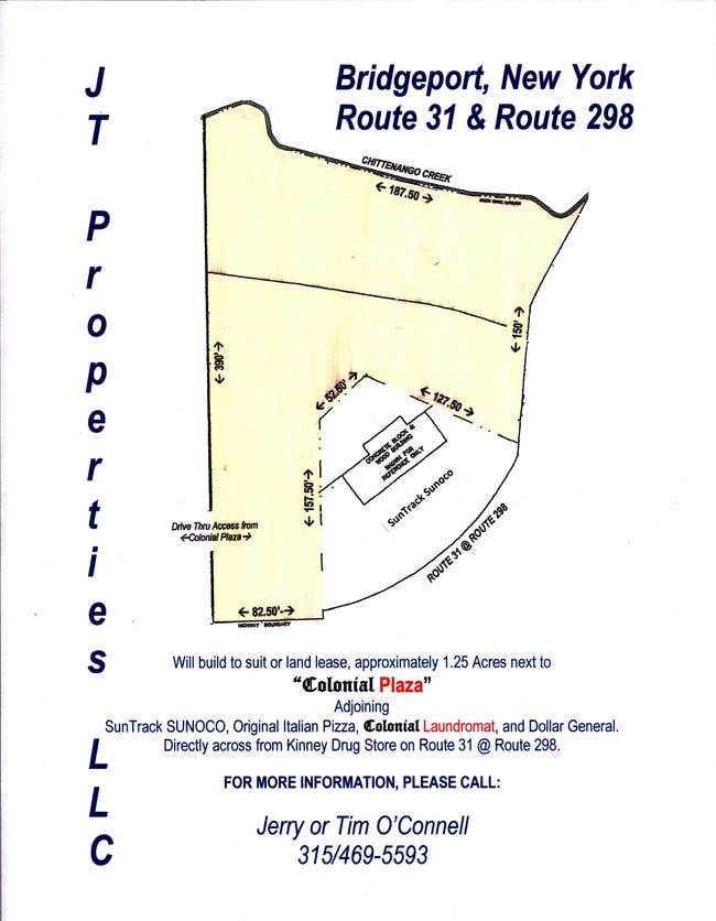
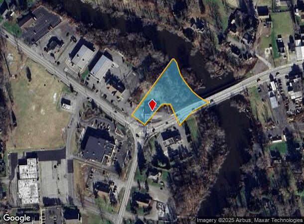
Property Record
8013 Route 31, Bridgeport, NY 13030
NEARBY LISTINGS FOR SALE OR LEASE
Property Detail
8013 Route 31
Syracuse, NY
FL 73 1150107
312289-069-000-0006-002-001-0000
Onondaga
Commercialacreage
New York
AE
2.001
36067C0138F
1.57 AC
2025
SE Outer Onondaga County
2024
Syracuse
030403
DEMOGRAPHICS near 8013 Route 31
1 Mile
3 Mile
5 Mile
2024 Total Population
2,079
5,129
11,654
2029 Population
2,069
5,127
11,638
Pop Growth 2024-2029
(0.48%)
(0.04%)
(0.14%)
Average Age
44
45
45
2024 Total Households
887
2,133
4,796
HH Growth 2024-2029
(0.79%)
(0.19%)
(0.25%)
Median Household Inc
$67,253
$74,563
$81,273
Avg Household Size
2.30
2.40
2.40
2024 Avg HH Vehicles
2.00
2.00
2.00
Median Home Value
$154,499
$217,326
$202,476
Median Year Built
1965
1967
1970
Nearby Places
Map Layers
Map Styles
 Street
 Aerial
- Restaurants
- Banks
- Shops
- Fitness
- Groceries
PUBLIC TRANSPORTATION
AIRPORT
Syracuse Hancock International
DRIVE
WALK
Distance
Syracuse Hancock International
21 min
11.7 mi
Nearby Properties
Address
Land Use
TOTAL SIZE
Lot Size
Zoning
Address
Land Use
TOTAL SIZE
Lot Size
Zoning
32,520 SF
31.41 AC
Address
Land Use
TOTAL SIZE
Lot Size
Zoning
5,256 SF
5.56 AC
Address
Land Use
TOTAL SIZE
Lot Size
Zoning
7,008 SF
7.75 AC
Address
Land Use
TOTAL SIZE
Lot Size
Zoning
16,890 SF
2.07 AC
Address
Land Use
TOTAL SIZE
Lot Size
Zoning
700 SF
45.42 AC
04
Address
Land Use
TOTAL SIZE
Lot Size
Zoning
2,520 SF
19.70 AC
Address
Land Use
TOTAL SIZE
Lot Size
Zoning
10,936 SF
321.40 AC
AG
Address
Land Use
TOTAL SIZE
Lot Size
Zoning
4,850 SF
1.73 AC
Address
Land Use
TOTAL SIZE
Lot Size
Zoning
1,436 SF
3.20 AC
Address
Land Use
TOTAL SIZE
Lot Size
Zoning
8,400 SF
5.26 AC
BUS
Address
Land Use
TOTAL SIZE
Lot Size
Zoning
9,863 SF
4.12 AC
Address
Land Use
TOTAL SIZE
Lot Size
Zoning
9,075 SF
1.41 AC
Address
Land Use
TOTAL SIZE
Lot Size
Zoning
10,156 SF
2.52 AC
05 - COMME
Address
Land Use
TOTAL SIZE
Lot Size
Zoning
Address
Land Use
TOTAL SIZE
Lot Size
Zoning
910 SF
47.41 AC
PUD-R
Address
Land Use
TOTAL SIZE
Lot Size
Zoning
2,476 SF
2.23 AC
BUS
Address
Land Use
TOTAL SIZE
Lot Size
Zoning
2,250 SF
1.57 AC
05 - COMME
Address
Land Use
TOTAL SIZE
Lot Size
Zoning
9,000 SF
5.14 AC
05 - COMME
Address
Land Use
TOTAL SIZE
Lot Size
Zoning
2,378 SF
0.69 AC
Address
Land Use
TOTAL SIZE
Lot Size
Zoning
14,340 SF
0.83 AC
R-10
Address
Land Use
TOTAL SIZE
Lot Size
Zoning
107.77 AC
Address
Land Use
TOTAL SIZE
Lot Size
Zoning
8,000 SF
74.99 AC
AG,R-8
Address
Land Use
TOTAL SIZE
Lot Size
Zoning
1,892 SF
1.09 AC
Address
Land Use
TOTAL SIZE
Lot Size
Zoning
4,264 SF
5.29 AC
02 - SINGL
Address
Land Use
TOTAL SIZE
Lot Size
Zoning
3,358 SF
1.60 AC
Address
Land Use
TOTAL SIZE
Lot Size
Zoning
1,849 SF
0.20 AC
R-10
Address
Land Use
TOTAL SIZE
Lot Size
Zoning
4,800 SF
1.17 AC
Address
Land Use
TOTAL SIZE
Lot Size
Zoning
9,000 SF
1.40 AC
Address
Land Use
TOTAL SIZE
Lot Size
Zoning
4,200 SF
1.07 AC
Address
Land Use
TOTAL SIZE
Lot Size
Zoning
1,200 SF
4.56 AC
The World's #1 Commercial Real Estate Marketplace
Connect with us
© 2026 CoStar Group
The information above has been obtained from sources believed reliable. While we do not doubt its accuracy we have not verified it and make no guarantee, warranty or representation about it. It is your responsibility to independently confirm its accuracy and completeness. Any projections, opinions, assumptions, or estimates used are for example only and do not represent the current or future performance of the property. The value of this transaction to you depends on tax and other factors which should be evaluated by your tax, financial, and legal advisors. You and your advisors should conduct a careful, independent investigation of the property to determine to your satisfaction the suitability of the property for your needs.