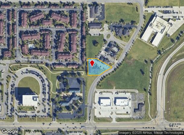
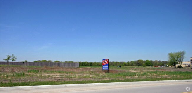
Property Record
8014 S 101St Ave E, Tulsa, OK 74133

NEARBY LISTINGS FOR SALE OR LEASE
Property Detail
8014 S 101St Ave E
Tulsa, OK
Tall Grass Office Park Resub L1 B1 Tall
77302-84-07-59870
LT 12 BLK 1
Medicalbuilding
Tulsa
X
Oklahoma
40143C0386M
12
2025
0.72 AC
2025
South Central
007527
Tulsa
10,060 SF
DEMOGRAPHICS near 8014 S 101St Ave E
1 Mile
3 Mile
5 Mile
2024 Total Population
11,363
82,571
222,401
2029 Population
11,747
84,912
228,978
Pop Growth 2024-2029
+ 3.38%
+ 2.84%
+ 2.96%
Average Age
39
40
39
2024 Total Households
5,080
33,689
89,548
HH Growth 2024-2029
+ 3.52%
+ 2.92%
+ 3.02%
Median Household Inc
$62,741
$71,961
$68,561
Avg Household Size
2.20
2.40
2.40
2024 Avg HH Vehicles
2.00
2.00
2.00
Median Home Value
$222,864
$213,893
$217,229
Median Year Built
1999
1987
1984
Nearby Places
Map Layers
Map Styles
 Street
 Aerial
- Restaurants
- Banks
- Shops
- Fitness
- Groceries
PUBLIC TRANSPORTATION
AIRPORT
Tulsa International
DRIVE
WALK
Distance
Tulsa International
22 min
15.3 mi
Freight Ports
DRIVE
WALK
Distance
26 min
19.1 mi
Nearby Properties
Address
Land Use
TOTAL SIZE
Lot Size
Zoning
Address
Land Use
TOTAL SIZE
Lot Size
Zoning
717,386 SF
49.74 AC
OL
Address
Land Use
TOTAL SIZE
Lot Size
Zoning
323,882 SF
20 AC
CO
Address
Land Use
TOTAL SIZE
Lot Size
Zoning
157,138 SF
9.28 AC
CO
Address
Land Use
TOTAL SIZE
Lot Size
Zoning
184,679 SF
33.97 AC
AG
Address
Land Use
TOTAL SIZE
Lot Size
Zoning
206,760 SF
78.45 AC
AG
Address
Land Use
TOTAL SIZE
Lot Size
Zoning
163,472 SF
29.92 AC
AG
Address
Land Use
TOTAL SIZE
Lot Size
Zoning
25,173 SF
155.93 AC
RS3
Address
Land Use
TOTAL SIZE
Lot Size
Zoning
592,682 SF
30.42 AC
CO
Address
Land Use
TOTAL SIZE
Lot Size
Zoning
55,384 SF
14.81 AC
AG
Address
Land Use
TOTAL SIZE
Lot Size
Zoning
90,533 SF
29.41 AC
A1
Address
Land Use
TOTAL SIZE
Lot Size
Zoning
176,243 SF
5.77 AC
CS
Address
Land Use
TOTAL SIZE
Lot Size
Zoning
152,422 SF
44.60 AC
AG
Address
Land Use
TOTAL SIZE
Lot Size
Zoning
625 SF
78.96 AC
RS3
Address
Land Use
TOTAL SIZE
Lot Size
Zoning
33,668 SF
8.04 AC
CO
Address
Land Use
TOTAL SIZE
Lot Size
Zoning
27,278 SF
2.49 AC
CS
Address
Land Use
TOTAL SIZE
Lot Size
Zoning
86,747 SF
19.01 AC
RS3
Address
Land Use
TOTAL SIZE
Lot Size
Zoning
56,526 SF
25.18 AC
AG
Address
Land Use
TOTAL SIZE
Lot Size
Zoning
84,314 SF
12.05 AC
A1
Address
Land Use
TOTAL SIZE
Lot Size
Zoning
57,630 SF
35.09 AC
IL
Address
Land Use
TOTAL SIZE
Lot Size
Zoning
68,478 SF
9.27 AC
R1
Address
Land Use
TOTAL SIZE
Lot Size
Zoning
260,059 SF
19.99 AC
CO
Address
Land Use
TOTAL SIZE
Lot Size
Zoning
71,362 SF
14.08 AC
RD
Address
Land Use
TOTAL SIZE
Lot Size
Zoning
35,904 SF
4.08 AC
RM1
Address
Land Use
TOTAL SIZE
Lot Size
Zoning
22,594 SF
2.07 AC
ON
Address
Land Use
TOTAL SIZE
Lot Size
Zoning
59,175 SF
8.28 AC
RS3
Address
Land Use
TOTAL SIZE
Lot Size
Zoning
20,292 SF
48.11 AC
CO
Address
Land Use
TOTAL SIZE
Lot Size
Zoning
60,790 SF
10.84 AC
R1
Address
Land Use
TOTAL SIZE
Lot Size
Zoning
330,744 SF
17.43 AC
RM3
Address
Land Use
TOTAL SIZE
Lot Size
Zoning
248,577 SF
12.01 AC
CG
Address
Land Use
TOTAL SIZE
Lot Size
Zoning
346,535 SF
19.58 AC
RS3
The World's #1 Commercial Real Estate Marketplace
Connect with us
© 2026 CoStar Group
The information above has been obtained from sources believed reliable. While we do not doubt its accuracy we have not verified it and make no guarantee, warranty or representation about it. It is your responsibility to independently confirm its accuracy and completeness. Any projections, opinions, assumptions, or estimates used are for example only and do not represent the current or future performance of the property. The value of this transaction to you depends on tax and other factors which should be evaluated by your tax, financial, and legal advisors. You and your advisors should conduct a careful, independent investigation of the property to determine to your satisfaction the suitability of the property for your needs.