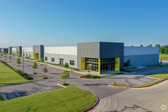
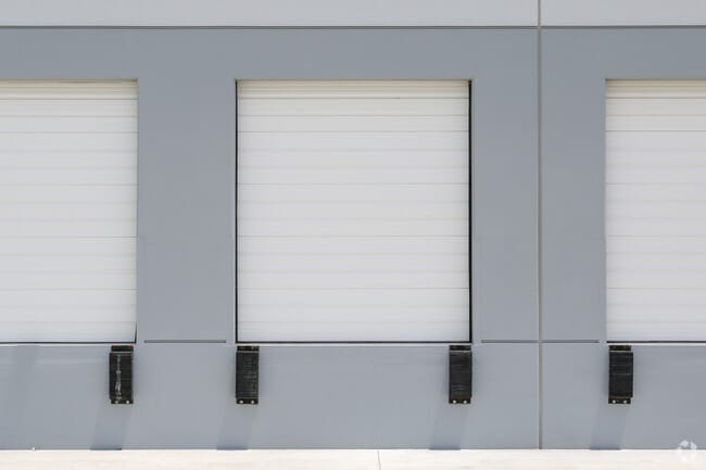
Property Record
8015 Burleson Rd, Austin, TX 78744

Property Detail
8015 Burleson Rd
Austin-Round Rock-San Marcos, TX
LOT 1 BLK A PARK 183 PHS 1
888430
Travis
Industrialgeneral
Texas
B and X Area of moderate flood hazard, usually the area between the limits of the 100-year and 500-year floods.
1
2025
10.01 AC
2025
Southeast
002432
Austin
131,893 SF
NEARBY LISTINGS FOR SALE OR LEASE
DEMOGRAPHICS near 8015 Burleson Rd
1 mile
3 mile
5 mile
2025 Total Population
2,120
30,615
156,826
2030 Population
2,344
33,146
166,353
Pop Growth 2025-2030
+ 10.57%
+ 8.27%
+ 6.07%
Average Age
36
35
34
2025 Total Households
769
10,498
61,061
HH Growth 2025-2030
+ 11.31%
+ 9.16%
+ 6.76%
Median Household Inc
$132,857
$97,384
$75,241
Avg Household Size
2.70
2.80
2.50
2025 Avg HH Vehicles
2.00
2.00
2.00
Median Home Value
$438,590
$444,081
$403,170
Median Year Built
2011
2010
2002
Nearby Places
Map Layers
Map Styles
 Street
 Aerial
Transit
 Traffic
 Biking
Places
Listings with unknown addresses are not visible on the map
- Restaurants
- Banks
- Shops
- Fitness
- Groceries
PUBLIC TRANSPORTATION
COMMUTER RAIL
Austin (Texas Eagle - Amtrak)
Drive
Walk
Distance
Austin (Texas Eagle - Amtrak)
17 min
9.7 mi
AIRPORT
Austin-Bergstrom International
Drive
Walk
Distance
Austin-Bergstrom International
10 min
3.6 mi
Freight Ports
Calhoun Port
Drive
Walk
Distance
Calhoun Port
176 min
147.1 mi
SALE & LEASE HISTORY
LISTING DATE
SALE/LEASE

Nov 07, 2016
For Lease
May 25, 2018
For Lease
Nearby Properties
Address
Land Use
TOTAL SIZE
Lot Size
Zoning
Address
Land Use
TOTAL SIZE
Lot Size
Zoning
942.08 AC
Address
Land Use
TOTAL SIZE
Lot Size
Zoning
307,610 SF
8.95 AC
Address
Land Use
TOTAL SIZE
Lot Size
Zoning
290,643 SF
13.59 AC
Address
Land Use
TOTAL SIZE
Lot Size
Zoning
255,483 SF
35 AC
Address
Land Use
TOTAL SIZE
Lot Size
Zoning
335,913 SF
13.83 AC
Address
Land Use
TOTAL SIZE
Lot Size
Zoning
390,384 SF
34.08 AC
Address
Land Use
TOTAL SIZE
Lot Size
Zoning
287,925 SF
9.92 AC
Address
Land Use
TOTAL SIZE
Lot Size
Zoning
193,788 SF
107.16 AC
Address
Land Use
TOTAL SIZE
Lot Size
Zoning
206,608 SF
10.61 AC
Address
Land Use
TOTAL SIZE
Lot Size
Zoning
288,174 SF
18.91 AC
Address
Land Use
TOTAL SIZE
Lot Size
Zoning
262,576 SF
15.68 AC
Address
Land Use
TOTAL SIZE
Lot Size
Zoning
323,360 SF
20.93 AC
Address
Land Use
TOTAL SIZE
Lot Size
Zoning
162,000 SF
12.62 AC
Address
Land Use
TOTAL SIZE
Lot Size
Zoning
368,244 SF
93.34 AC
Address
Land Use
TOTAL SIZE
Lot Size
Zoning
353,770 SF
23.97 AC
Address
Land Use
TOTAL SIZE
Lot Size
Zoning
326,400 SF
26.12 AC
Address
Land Use
TOTAL SIZE
Lot Size
Zoning
345,600 SF
49.73 AC
Address
Land Use
TOTAL SIZE
Lot Size
Zoning
214,303 SF
11.32 AC
Address
Land Use
TOTAL SIZE
Lot Size
Zoning
351,255 SF
12.45 AC
Address
Land Use
TOTAL SIZE
Lot Size
Zoning
257,600 SF
26.83 AC
Address
Land Use
TOTAL SIZE
Lot Size
Zoning
221,646 SF
6.71 AC
Address
Land Use
TOTAL SIZE
Lot Size
Zoning
249,216 SF
20.19 AC
Address
Land Use
TOTAL SIZE
Lot Size
Zoning
166,770 SF
13.51 AC
Address
Land Use
TOTAL SIZE
Lot Size
Zoning
172,800 SF
22.82 AC
Address
Land Use
TOTAL SIZE
Lot Size
Zoning
247,104 SF
9.39 AC
Address
Land Use
TOTAL SIZE
Lot Size
Zoning
348,838 SF
4.16 AC
Address
Land Use
TOTAL SIZE
Lot Size
Zoning
264,765 SF
23.37 AC
Address
Land Use
TOTAL SIZE
Lot Size
Zoning
309,375 SF
18.04 AC
Address
Land Use
TOTAL SIZE
Lot Size
Zoning
267,024 SF
25.97 AC
Address
Land Use
TOTAL SIZE
Lot Size
Zoning
167,500 SF
14.03 AC
The World's #1 Commercial Real Estate Marketplace
Connect with us
© 2026 CoStar Group
The information above has been obtained from sources believed reliable. While we do not doubt its accuracy we have not verified it and make no guarantee, warranty or representation about it. It is your responsibility to independently confirm its accuracy and completeness. Any projections, opinions, assumptions, or estimates used are for example only and do not represent the current or future performance of the property. The value of this transaction to you depends on tax and other factors which should be evaluated by your tax, financial, and legal advisors. You and your advisors should conduct a careful, independent investigation of the property to determine to your satisfaction the suitability of the property for your needs.