Property Record
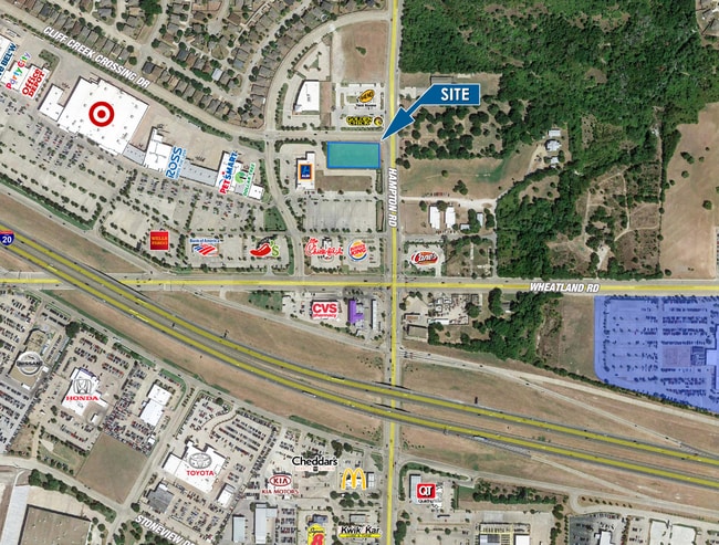
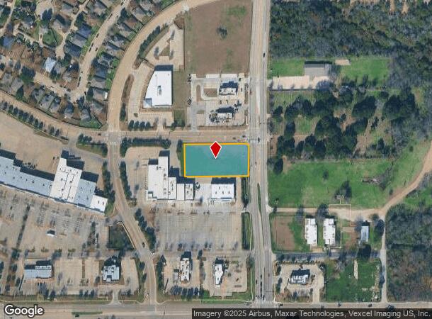
8017 S Hampton Rd, Dallas, TX 75232
NEARBY LISTINGS FOR SALE OR LEASE
Property Detail
8017 S Hampton Rd
Dallas-Fort Worth-Arlington, TX
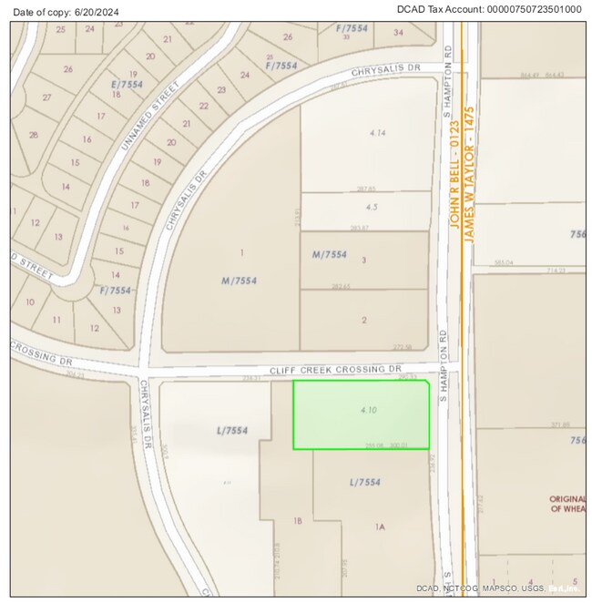
J R Bell Survey Abstract #123
00000750723501000
BLK 7554 TR 4.10 ACS 1.032 INT202400115492 DD06072024 CO-DC 7554 000 00410 2007554 000
Carwash
Dallas
X
Texas
48113C0490K
4
2024
1.03 AC
2025
Southwest Dallas
010906
Dallas/Ft Worth
3,947 SF
DEMOGRAPHICS near 8017 S Hampton Rd
1 Mile
3 Mile
5 Mile
2024 Total Population
10,083
81,770
234,944
2029 Population
9,929
80,225
230,758
Pop Growth 2024-2029
(1.53%)
(1.89%)
(1.78%)
Average Age
34
37
37
2024 Total Households
3,475
29,695
80,364
HH Growth 2024-2029
(1.76%)
(2.20%)
(2.13%)
Median Household Inc
$45,445
$44,012
$52,674
Avg Household Size
2.80
2.70
2.80
2024 Avg HH Vehicles
1.00
2.00
2.00
Median Home Value
$179,155
$187,085
$201,286
Median Year Built
1985
1980
1980
Nearby Places
Map Layers
Map Styles
 Street
 Aerial
- Restaurants
- Banks
- Shops
- Fitness
- Groceries
PUBLIC TRANSPORTATION
AIRPORT
Dallas Love Field
DRIVE
WALK
Distance
Dallas Love Field
29 min
18.5 mi
Dallas-Fort Worth International
DRIVE
WALK
Distance
Dallas-Fort Worth International
32 min
27.8 mi
Nearby Properties
Address
Land Use
TOTAL SIZE
Lot Size
Zoning
Address
Land Use
TOTAL SIZE
Lot Size
Zoning
726,662 SF
44.94 AC
Z239
Address
Land Use
TOTAL SIZE
Lot Size
Zoning
1,316,325 SF
54.36 AC
Z111
Address
Land Use
TOTAL SIZE
Lot Size
Zoning
1,126,320 SF
63.41 AC
Z111
Address
Land Use
TOTAL SIZE
Lot Size
Zoning
1,167,500 SF
46.04 AC
Z06
Address
Land Use
TOTAL SIZE
Lot Size
Zoning
951,480 SF
50.63 AC
Z109
Address
Land Use
TOTAL SIZE
Lot Size
Zoning
948,392 SF
50.80 AC
Z109
Address
Land Use
TOTAL SIZE
Lot Size
Zoning
872,640 SF
46.97 AC
Z125
Address
Land Use
TOTAL SIZE
Lot Size
Zoning
823,000 SF
45.10 AC
Z298
Address
Land Use
TOTAL SIZE
Lot Size
Zoning
662,230 SF
38.49 AC
Z248
Address
Land Use
TOTAL SIZE
Lot Size
Zoning
399,458 SF
24.51 AC
MF2
Address
Land Use
TOTAL SIZE
Lot Size
Zoning
660,400 SF
35.93 AC
Z125
Address
Land Use
TOTAL SIZE
Lot Size
Zoning
595,148 SF
34.96 AC
Z39
Address
Land Use
TOTAL SIZE
Lot Size
Zoning
507,318 SF
28.40 AC
Z111
Address
Land Use
TOTAL SIZE
Lot Size
Zoning
172,840 SF
49.65 AC
Z164
Address
Land Use
TOTAL SIZE
Lot Size
Zoning
552,200 SF
41.36 AC
Z109
Address
Land Use
TOTAL SIZE
Lot Size
Zoning
489,310 SF
33.91 AC
Z111
Address
Land Use
TOTAL SIZE
Lot Size
Zoning
374,400 SF
6.15 AC
Z150
Address
Land Use
TOTAL SIZE
Lot Size
Zoning
531,254 SF
33.40 AC
Z06
Address
Land Use
TOTAL SIZE
Lot Size
Zoning
453,600 SF
29.54 AC
Z236
Address
Land Use
TOTAL SIZE
Lot Size
Zoning
421,890 SF
23.95 AC
Z111
Address
Land Use
TOTAL SIZE
Lot Size
Zoning
400,000 SF
24.69 AC
Z116
Address
Land Use
TOTAL SIZE
Lot Size
Zoning
444,216 SF
23.99 AC
Z39
Address
Land Use
TOTAL SIZE
Lot Size
Zoning
344,952 SF
14.39 AC
Z239
Address
Land Use
TOTAL SIZE
Lot Size
Zoning
389,900 SF
22.88 AC
Z298
Address
Land Use
TOTAL SIZE
Lot Size
Zoning
222,576 SF
35.20 AC
Z239
Address
Land Use
TOTAL SIZE
Lot Size
Zoning
273,914 SF
46.58 AC
Z413
Address
Land Use
TOTAL SIZE
Lot Size
Zoning
418,511 SF
20.38 AC
Z111
Address
Land Use
TOTAL SIZE
Lot Size
Zoning
350,904 SF
18.46 AC
Z111
Address
Land Use
TOTAL SIZE
Lot Size
Zoning
346,500 SF
22.27 AC
Z125
Address
Land Use
TOTAL SIZE
Lot Size
Zoning
305,727 SF
25.02 AC
Z06
The World's #1 Commercial Real Estate Marketplace
Connect with us
© 2025 CoStar Group
The information above has been obtained from sources believed reliable. While we do not doubt its accuracy we have not verified it and make no guarantee, warranty or representation about it. It is your responsibility to independently confirm its accuracy and completeness. Any projections, opinions, assumptions, or estimates used are for example only and do not represent the current or future performance of the property. The value of this transaction to you depends on tax and other factors which should be evaluated by your tax, financial, and legal advisors. You and your advisors should conduct a careful, independent investigation of the property to determine to your satisfaction the suitability of the property for your needs.