Property Record
8019 E M 71, Durand, MI 48429
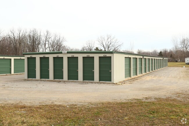


Property Detail
8019 E M 71
012-09-300-001
SEC 9, T6N, R4E COM AT PT WHICH IS S8810'19!E 716.75 FT FROM W 14 POST OF SEC CONT S8810'19!E 304.02 FT, S0134'49!W 436.18 FT
Commercialnec
SHIAWASSEE
B and X Area of moderate flood hazard, usually the area between the limits of the 100-year and 500-year floods.
Michigan
2025
8.10 AC
2025
Other Market Areas
031800
Owosso, MI
NEARBY LISTINGS FOR SALE OR LEASE
-
-
View all Durand listings for sale on LoopNet.com
DEMOGRAPHICS near 8019 E M 71
1 mile
3 mile
5 mile
2025 Total Population
773
6,871
12,539
2030 Population
771
6,885
12,675
Pop Growth 2025-2030
(0.26%)
+ 0.20%
+ 1.08%
Average Age
44
43
43
2025 Total Households
345
2,953
5,230
HH Growth 2025-2030
0.00%
+ 0.34%
+ 1.19%
Median Household Inc
$49,740
$53,948
$58,092
Avg Household Size
2.10
2.30
2.30
2025 Avg HH Vehicles
2.00
2.00
2.00
Median Home Value
$143,181
$152,007
$163,907
Median Year Built
1969
1962
1969
Nearby Places
Map Layers
Map Styles
 Street
 Aerial
Layers
 Traffic
 Biking
Places
Listings with unknown addresses are not visible on the map
- Restaurants
- Banks
- Shops
- Fitness
- Groceries
PUBLIC TRANSPORTATION
COMMUTER RAIL
Drive
Walk
Distance
7 min
2.9 mi
AIRPORT
Bishop International
Drive
Walk
Distance
Bishop International
28 min
17.3 mi
Capital Region International
Drive
Walk
Distance
Capital Region International
45 min
38.8 mi
Nearby Properties
Address
Land Use
TOTAL SIZE
Lot Size
Zoning
Address
Land Use
TOTAL SIZE
Lot Size
Zoning
46,164 SF
5.51 AC
R-M
Address
Land Use
TOTAL SIZE
Lot Size
Zoning
12,890 SF
0.54 AC
R-1
Address
Land Use
TOTAL SIZE
Lot Size
Zoning
118,988 SF
22.79 AC
I-2
Address
Land Use
TOTAL SIZE
Lot Size
Zoning
87,234 SF
8.33 AC
R-M
Address
Land Use
TOTAL SIZE
Lot Size
Zoning
32,792 SF
11.52 AC
C-2
Address
Land Use
TOTAL SIZE
Lot Size
Zoning
66 AC
Address
Land Use
TOTAL SIZE
Lot Size
Zoning
67.70 AC
Address
Land Use
TOTAL SIZE
Lot Size
Zoning
18,780 SF
2.52 AC
R-M
Address
Land Use
TOTAL SIZE
Lot Size
Zoning
19,800 SF
2.66 AC
R-M
Address
Land Use
TOTAL SIZE
Lot Size
Zoning
7.01 AC
Address
Land Use
TOTAL SIZE
Lot Size
Zoning
27,888 SF
2.59 AC
C-1
Address
Land Use
TOTAL SIZE
Lot Size
Zoning
157.53 AC
Address
Land Use
TOTAL SIZE
Lot Size
Zoning
3.70 AC
Address
Land Use
TOTAL SIZE
Lot Size
Zoning
15,000 SF
3.03 AC
I-2
Address
Land Use
TOTAL SIZE
Lot Size
Zoning
27.60 AC
Address
Land Use
TOTAL SIZE
Lot Size
Zoning
11,100 SF
1.57 AC
C-2
Address
Land Use
TOTAL SIZE
Lot Size
Zoning
11,703 SF
1.99 AC
C-2
Address
Land Use
TOTAL SIZE
Lot Size
Zoning
3,168 SF
1.09 AC
C-2
Address
Land Use
TOTAL SIZE
Lot Size
Zoning
196.80 AC
Address
Land Use
TOTAL SIZE
Lot Size
Zoning
5,600 SF
0.69 AC
R-1
Address
Land Use
TOTAL SIZE
Lot Size
Zoning
Address
Land Use
TOTAL SIZE
Lot Size
Zoning
16.48 AC
Address
Land Use
TOTAL SIZE
Lot Size
Zoning
Address
Land Use
TOTAL SIZE
Lot Size
Zoning
9,301 SF
2.29 AC
R-M
Address
Land Use
TOTAL SIZE
Lot Size
Zoning
20,982 SF
2.88 AC
R-M
Address
Land Use
TOTAL SIZE
Lot Size
Zoning
1,560 SF
0.96 AC
C-2
Address
Land Use
TOTAL SIZE
Lot Size
Zoning
146.30 AC
Address
Land Use
TOTAL SIZE
Lot Size
Zoning
120 AC
Address
Land Use
TOTAL SIZE
Lot Size
Zoning
19,200 SF
1.44 AC
R-M
The World's #1 Commercial Real Estate Marketplace
Connect with us
© 2026 CoStar Group
The information above has been obtained from sources believed reliable. While we do not doubt its accuracy we have not verified it and make no guarantee, warranty or representation about it. It is your responsibility to independently confirm its accuracy and completeness. Any projections, opinions, assumptions, or estimates used are for example only and do not represent the current or future performance of the property. The value of this transaction to you depends on tax and other factors which should be evaluated by your tax, financial, and legal advisors. You and your advisors should conduct a careful, independent investigation of the property to determine to your satisfaction the suitability of the property for your needs.