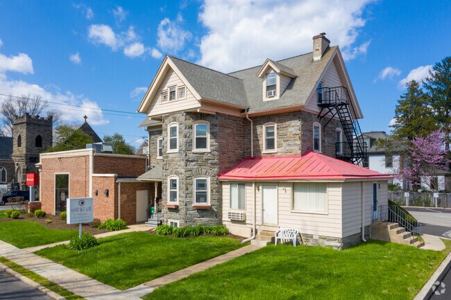
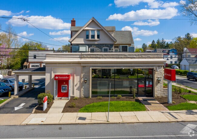
Property Record
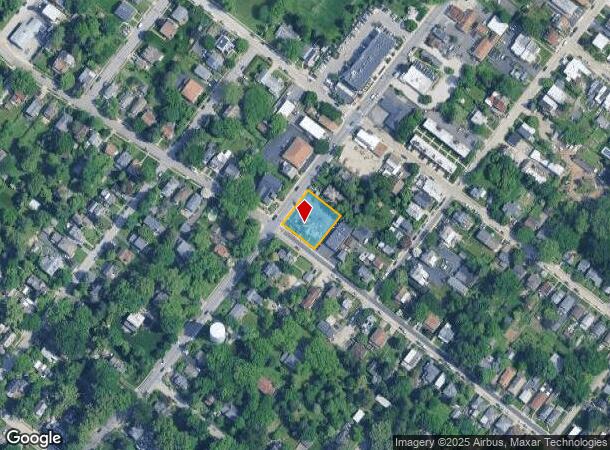
802 E Willow Grove Ave, Glenside, PA 19038
NEARBY LISTINGS FOR SALE OR LEASE
Property Detail
802 E Willow Grove Ave
52-00-18577-001
ASSESSOR BLOCK-UNIT NUMBER 26-55
Commercialnec
Montgomery
X
Pennsylvania
42091C0379G
55
2024
0.35 AC
2025
Ft Wash/Spring House
202604
Philadelphia
6,403 SF
Philadelphia-Camden-Wilmington, PA-NJ-DE-MD
DEMOGRAPHICS near 802 E Willow Grove Ave
1 Mile
3 Mile
5 Mile
2024 Total Population
19,656
166,238
414,403
2029 Population
19,147
163,572
408,441
Pop Growth 2024-2029
(2.59%)
(1.60%)
(1.44%)
Average Age
45
42
41
2024 Total Households
8,176
68,427
169,972
HH Growth 2024-2029
(3.39%)
(1.82%)
(1.62%)
Median Household Inc
$72,153
$69,137
$70,366
Avg Household Size
2.20
2.30
2.30
2024 Avg HH Vehicles
1.00
1.00
1.00
Median Home Value
$320,357
$277,634
$276,356
Median Year Built
1953
1950
1951
Nearby Places
Map Layers
Map Styles
 Street
 Aerial
- Restaurants
- Banks
- Shops
- Fitness
- Groceries
PUBLIC TRANSPORTATION
TRANSIT/SUBWAY
Wyndmoor (R7 - Southeastern Pennsylvania Transportation Authority Regional Rail (SEPTA Regional Rail))
DRIVE
WALK
Distance
Wyndmoor (R7 - Southeastern Pennsylvania Transportation Authority Regional Rail (SEPTA Regional Rail))
3 min
14 min
0.7 mi
Gravers (R7 - Southeastern Pennsylvania Transportation Authority Regional Rail (SEPTA Regional Rail))
DRIVE
WALK
Distance
Gravers (R7 - Southeastern Pennsylvania Transportation Authority Regional Rail (SEPTA Regional Rail))
4 min
19 min
1.0 mi
COMMUTER RAIL
Wyndmoor (R7 - Southeastern Pennsylvania Transportation Authority Regional Rail (SEPTA Regional Rail))
DRIVE
WALK
Distance
Wyndmoor (R7 - Southeastern Pennsylvania Transportation Authority Regional Rail (SEPTA Regional Rail))
3 min
15 min
0.7 mi
Gravers (R7 - Southeastern Pennsylvania Transportation Authority Regional Rail (SEPTA Regional Rail))
DRIVE
WALK
Distance
Gravers (R7 - Southeastern Pennsylvania Transportation Authority Regional Rail (SEPTA Regional Rail))
4 min
20 min
1.0 mi
AIRPORT
Philadelphia International
DRIVE
WALK
Distance
Philadelphia International
41 min
21.5 mi
Trenton Mercer
DRIVE
WALK
Distance
Trenton Mercer
50 min
33.6 mi
Freight Ports
Port of Philadelphia
DRIVE
WALK
Distance
Port of Philadelphia
20 min
10.9 mi
SALE & LEASE HISTORY
LISTING DATE
SALE/LEASE

May 19, 2022
For Lease
Dec 06, 2021
For Sale
Nearby Properties
Address
Land Use
TOTAL SIZE
Lot Size
Zoning
Address
Land Use
TOTAL SIZE
Lot Size
Zoning
638,776 SF
20 AC
RM2
Address
Land Use
TOTAL SIZE
Lot Size
Zoning
2,146,150 SF
119.95 AC
M1
Address
Land Use
TOTAL SIZE
Lot Size
Zoning
609,000 SF
22.44 AC
RM2
Address
Land Use
TOTAL SIZE
Lot Size
Zoning
563,768 SF
20.20 AC
RM2
Address
Land Use
TOTAL SIZE
Lot Size
Zoning
287,286 SF
1.26 AC
CMX5
Address
Land Use
TOTAL SIZE
Lot Size
Zoning
649,400 SF
55.03 AC
R1
Address
Land Use
TOTAL SIZE
Lot Size
Zoning
568,410 SF
33.08 AC
RMX1
Address
Land Use
TOTAL SIZE
Lot Size
Zoning
249,341 SF
21.82 AC
CA2
Address
Land Use
TOTAL SIZE
Lot Size
Zoning
415,059 SF
11.59 AC
RSD3
Address
Land Use
TOTAL SIZE
Lot Size
Zoning
211,200 SF
1.46 AC
CMX2
Address
Land Use
TOTAL SIZE
Lot Size
Zoning
300 AC
RSD1
Address
Land Use
TOTAL SIZE
Lot Size
Zoning
57,301 SF
49.77 AC
SPPOA
Address
Land Use
TOTAL SIZE
Lot Size
Zoning
170,842 SF
16.51 AC
RSD1
Address
Land Use
TOTAL SIZE
Lot Size
Zoning
148,293 SF
7.45 AC
RM2
Address
Land Use
TOTAL SIZE
Lot Size
Zoning
705,687 SF
19.89 AC
C1
Address
Land Use
TOTAL SIZE
Lot Size
Zoning
263,000 SF
5.31 AC
RM2
Address
Land Use
TOTAL SIZE
Lot Size
Zoning
234,934 SF
43.63 AC
AA
Address
Land Use
TOTAL SIZE
Lot Size
Zoning
233,235 SF
7.93 AC
RM2
Address
Land Use
TOTAL SIZE
Lot Size
Zoning
635,387 SF
10.12 AC
C1
Address
Land Use
TOTAL SIZE
Lot Size
Zoning
131,720 SF
4.33 AC
RM2
Address
Land Use
TOTAL SIZE
Lot Size
Zoning
135,423 SF
5.04 AC
RM3
Address
Land Use
TOTAL SIZE
Lot Size
Zoning
134,345 SF
25.45 AC
RSD1
Address
Land Use
TOTAL SIZE
Lot Size
Zoning
360,524 SF
59.87 AC
INST
Address
Land Use
TOTAL SIZE
Lot Size
Zoning
582,294 SF
9.07 AC
C1
Address
Land Use
TOTAL SIZE
Lot Size
Zoning
615,217 SF
33.52 AC
C2
Address
Land Use
TOTAL SIZE
Lot Size
Zoning
182,130 SF
6.45 AC
RSA3
Address
Land Use
TOTAL SIZE
Lot Size
Zoning
180,066 SF
59.77 AC
RSA3
Address
Land Use
TOTAL SIZE
Lot Size
Zoning
88,400 SF
1.79 AC
CMX2
Address
Land Use
TOTAL SIZE
Lot Size
Zoning
336,650 SF
61.74 AC
R3
Address
Land Use
TOTAL SIZE
Lot Size
Zoning
232,190 SF
34.16 AC
R4
The World's #1 Commercial Real Estate Marketplace
Connect with us
© 2025 CoStar Group
The information above has been obtained from sources believed reliable. While we do not doubt its accuracy we have not verified it and make no guarantee, warranty or representation about it. It is your responsibility to independently confirm its accuracy and completeness. Any projections, opinions, assumptions, or estimates used are for example only and do not represent the current or future performance of the property. The value of this transaction to you depends on tax and other factors which should be evaluated by your tax, financial, and legal advisors. You and your advisors should conduct a careful, independent investigation of the property to determine to your satisfaction the suitability of the property for your needs.