Property Record
802 Florala Hwy, Opp, AL 36467
NEARBY LISTINGS FOR SALE OR LEASE
-
-
View all Opp listings for sale on LoopNet.com
Property Detail
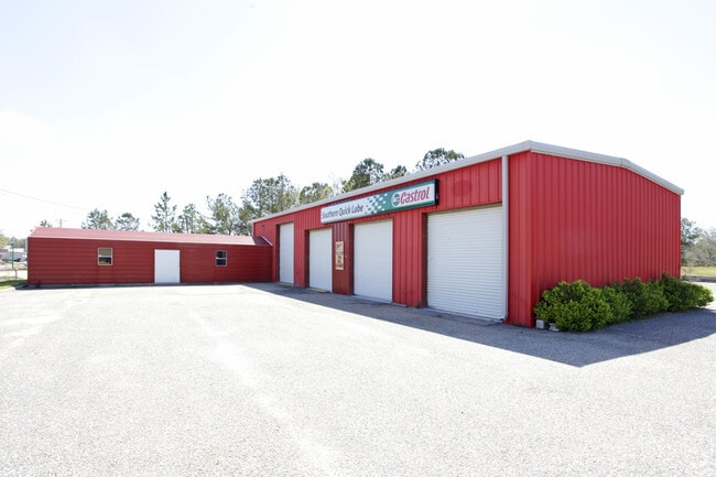
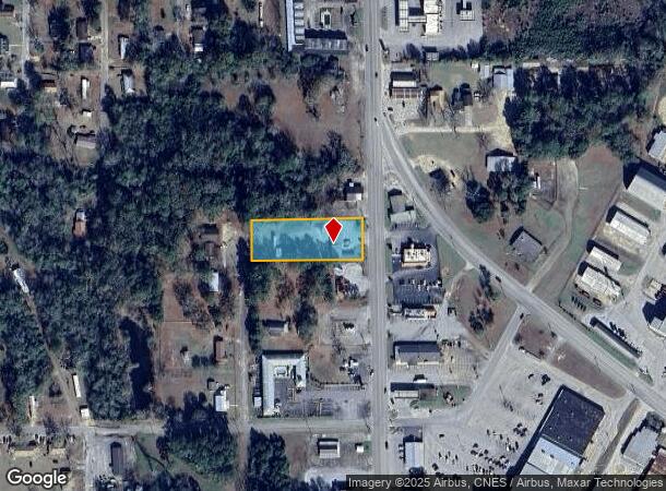
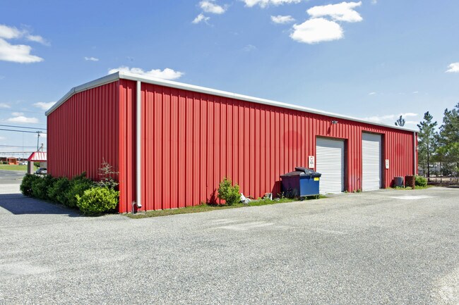
802 Florala Hwy
11-08-33-1-004-028.001
Benton Subd.
Autorepair
DB/PG>2022/21299 JSD 9/27/2022 LOTS 11-12 & 19-20 & N2 OF LOTS 10 & 21 BLK D BENTON SUB SEC 33 T4N R18E PB 2 PG 94 **PERFORMA
X
Covington
01031C0225C
Alabama
2025
11-12
2024
0.50 AC
962700
Alabama South Area
2,310 SF
Other Market Areas
DEMOGRAPHICS near 802 Florala Hwy
1 Mile
3 Mile
5 Mile
2024 Total Population
2,613
6,902
8,780
2029 Population
2,592
6,834
8,724
Pop Growth 2024-2029
(0.80%)
(0.99%)
(0.64%)
Average Age
42
42
43
2024 Total Households
1,047
2,782
3,553
HH Growth 2024-2029
(0.67%)
(0.97%)
(0.62%)
Median Household Inc
$36,947
$39,734
$40,804
Avg Household Size
2.30
2.30
2.30
2024 Avg HH Vehicles
2.00
2.00
2.00
Median Home Value
$93,768
$96,723
$101,549
Median Year Built
1968
1972
1975
Nearby Places
Map Layers
Map Styles
 Street
 Aerial
- Restaurants
- Banks
- Shops
- Fitness
- Groceries
Nearby Properties
Address
Land Use
TOTAL SIZE
Lot Size
Zoning
Address
Land Use
TOTAL SIZE
Lot Size
Zoning
6,860 SF
5 AC
Address
Land Use
TOTAL SIZE
Lot Size
Zoning
3,600 SF
13 AC
Address
Land Use
TOTAL SIZE
Lot Size
Zoning
23,392 SF
3 AC
Address
Land Use
TOTAL SIZE
Lot Size
Zoning
15,018 SF
0.70 AC
Address
Land Use
TOTAL SIZE
Lot Size
Zoning
14,107 SF
4 AC
Address
Land Use
TOTAL SIZE
Lot Size
Zoning
52,622 SF
7.80 AC
Address
Land Use
TOTAL SIZE
Lot Size
Zoning
8,220 SF
1.16 AC
Address
Land Use
TOTAL SIZE
Lot Size
Zoning
5,934 SF
1.70 AC
Address
Land Use
TOTAL SIZE
Lot Size
Zoning
58,600 SF
4.80 AC
Address
Land Use
TOTAL SIZE
Lot Size
Zoning
9,292 SF
4.20 AC
Address
Land Use
TOTAL SIZE
Lot Size
Zoning
1,932 SF
1.48 AC
Address
Land Use
TOTAL SIZE
Lot Size
Zoning
6,832 SF
3.10 AC
Address
Land Use
TOTAL SIZE
Lot Size
Zoning
25,480 SF
1.08 AC
Address
Land Use
TOTAL SIZE
Lot Size
Zoning
2,304 SF
2.37 AC
Address
Land Use
TOTAL SIZE
Lot Size
Zoning
9,304 SF
1.98 AC
Address
Land Use
TOTAL SIZE
Lot Size
Zoning
28,685 SF
Address
Land Use
TOTAL SIZE
Lot Size
Zoning
5,839 SF
3.53 AC
Address
Land Use
TOTAL SIZE
Lot Size
Zoning
31,592 SF
2.92 AC
Address
Land Use
TOTAL SIZE
Lot Size
Zoning
8,928 SF
0.17 AC
Address
Land Use
TOTAL SIZE
Lot Size
Zoning
17,300 SF
1.28 AC
Address
Land Use
TOTAL SIZE
Lot Size
Zoning
4,187 SF
2.41 AC
Address
Land Use
TOTAL SIZE
Lot Size
Zoning
6,840 SF
2.50 AC
Address
Land Use
TOTAL SIZE
Lot Size
Zoning
17,196 SF
1.86 AC
Address
Land Use
TOTAL SIZE
Lot Size
Zoning
44,000 SF
9.60 AC
Address
Land Use
TOTAL SIZE
Lot Size
Zoning
1,250 SF
2.38 AC
Address
Land Use
TOTAL SIZE
Lot Size
Zoning
27,108 SF
4.70 AC
The World's #1 Commercial Real Estate Marketplace
Connect with us
© 2025 CoStar Group
The information above has been obtained from sources believed reliable. While we do not doubt its accuracy we have not verified it and make no guarantee, warranty or representation about it. It is your responsibility to independently confirm its accuracy and completeness. Any projections, opinions, assumptions, or estimates used are for example only and do not represent the current or future performance of the property. The value of this transaction to you depends on tax and other factors which should be evaluated by your tax, financial, and legal advisors. You and your advisors should conduct a careful, independent investigation of the property to determine to your satisfaction the suitability of the property for your needs.