Property Record
802 Getwell Rd S, Hernando, MS 38632

Property Detail
802 Getwell Rd S
Memphis, TN-MS-AR
PT SE1/4 PT SW1/4
3072090000000802
DESOTO
Vacantlandnec
Mississippi
PUD
8
AE The base floodplain where base flood elevations are provided. AE Zones are now used on new format FIRMs instead of A1-A30 Zones.
74.51 AC
2025
DeSoto County
2025
Memphis
071002
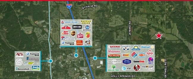
NEARBY LISTINGS FOR SALE OR LEASE
DEMOGRAPHICS near 802 Getwell Rd S
1 mile
3 mile
5 mile
2025 Total Population
1,579
15,447
31,655
2030 Population
1,675
16,201
33,315
Pop Growth 2025-2030
+ 6.08%
+ 4.88%
+ 5.24%
Average Age
40
39
39
2025 Total Households
532
5,564
11,122
HH Growth 2025-2030
+ 6.20%
+ 4.78%
+ 5.27%
Median Household Inc
$136,500
$87,869
$97,117
Avg Household Size
2.90
2.80
2.80
2025 Avg HH Vehicles
3.00
2.00
2.00
Median Home Value
$409,537
$335,239
$348,455
Median Year Built
2003
2000
2001
Nearby Places
Map Layers
Map Styles
 Street
 Aerial
Transit
 Traffic
 Biking
Places
Listings with unknown addresses are not visible on the map
- Restaurants
- Banks
- Shops
- Fitness
- Groceries
PUBLIC TRANSPORTATION
AIRPORT
Memphis International
Drive
Walk
Distance
Memphis International
30 min
20.5 mi
Freight Ports
Port of Shreveport
Drive
Walk
Distance
Port of Shreveport
432 min
394.1 mi
SALE & LEASE HISTORY
LISTING DATE
SALE/LEASE

Sep 24, 2016
For Sale
Feb 21, 2024
For Sale
Nearby Properties
Address
Land Use
TOTAL SIZE
Lot Size
Zoning
Address
Land Use
TOTAL SIZE
Lot Size
Zoning
19,367 SF
20.34 AC
PUD
Address
Land Use
TOTAL SIZE
Lot Size
Zoning
158,963 SF
20.07 AC
PUD
Address
Land Use
TOTAL SIZE
Lot Size
Zoning
120,095 SF
19.42 AC
C-2
Address
Land Use
TOTAL SIZE
Lot Size
Zoning
242,220 SF
27.54 AC
M-2
Address
Land Use
TOTAL SIZE
Lot Size
Zoning
13,533 SF
1.50 AC
PUD
Address
Land Use
TOTAL SIZE
Lot Size
Zoning
71,484 SF
6.45 AC
C-2
Address
Land Use
TOTAL SIZE
Lot Size
Zoning
37,622 SF
5.63 AC
PUD
Address
Land Use
TOTAL SIZE
Lot Size
Zoning
12,002 SF
1.15 AC
M-1
Address
Land Use
TOTAL SIZE
Lot Size
Zoning
18,556 SF
5.50 AC
C-2
Address
Land Use
TOTAL SIZE
Lot Size
Zoning
45,515 SF
2.60 AC
C-2
Address
Land Use
TOTAL SIZE
Lot Size
Zoning
3.12 AC
PUD
Address
Land Use
TOTAL SIZE
Lot Size
Zoning
54,098 SF
9.27 AC
M-1
Address
Land Use
TOTAL SIZE
Lot Size
Zoning
53,623 SF
2.69 AC
C-2
Address
Land Use
TOTAL SIZE
Lot Size
Zoning
15.10 AC
C-2
Address
Land Use
TOTAL SIZE
Lot Size
Zoning
45,789 SF
10 AC
M-2
Address
Land Use
TOTAL SIZE
Lot Size
Zoning
100,000 SF
9.90 AC
M-2
Address
Land Use
TOTAL SIZE
Lot Size
Zoning
46,498 SF
8.26 AC
M-1
Address
Land Use
TOTAL SIZE
Lot Size
Zoning
20,386 SF
3.24 AC
C-4
Address
Land Use
TOTAL SIZE
Lot Size
Zoning
44,973 SF
4 AC
M-2
Address
Land Use
TOTAL SIZE
Lot Size
Zoning
8,076 SF
4.04 AC
C-2
Address
Land Use
TOTAL SIZE
Lot Size
Zoning
21,206 SF
1.25 AC
C-4
Address
Land Use
TOTAL SIZE
Lot Size
Zoning
9,450 SF
2.49 AC
C-2
Address
Land Use
TOTAL SIZE
Lot Size
Zoning
17,278 SF
1.73 AC
C-2
Address
Land Use
TOTAL SIZE
Lot Size
Zoning
63,226 SF
3 AC
M-1
Address
Land Use
TOTAL SIZE
Lot Size
Zoning
6,720 SF
1.40 AC
C-2
Address
Land Use
TOTAL SIZE
Lot Size
Zoning
15,360 SF
1.67 AC
C-2
Address
Land Use
TOTAL SIZE
Lot Size
Zoning
22,650 SF
5 AC
M-1
Address
Land Use
TOTAL SIZE
Lot Size
Zoning
14,298 SF
3.09 AC
C-4
Address
Land Use
TOTAL SIZE
Lot Size
Zoning
6,756 SF
2.90 AC
RM-6
Address
Land Use
TOTAL SIZE
Lot Size
Zoning
17,905 SF
1.52 AC
C-2
The World's #1 Commercial Real Estate Marketplace
Connect with us
© 2026 CoStar Group
The information above has been obtained from sources believed reliable. While we do not doubt its accuracy we have not verified it and make no guarantee, warranty or representation about it. It is your responsibility to independently confirm its accuracy and completeness. Any projections, opinions, assumptions, or estimates used are for example only and do not represent the current or future performance of the property. The value of this transaction to you depends on tax and other factors which should be evaluated by your tax, financial, and legal advisors. You and your advisors should conduct a careful, independent investigation of the property to determine to your satisfaction the suitability of the property for your needs.