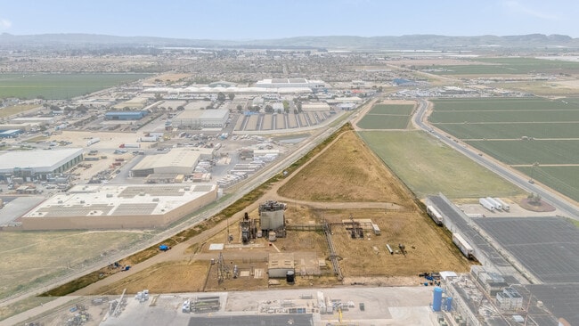
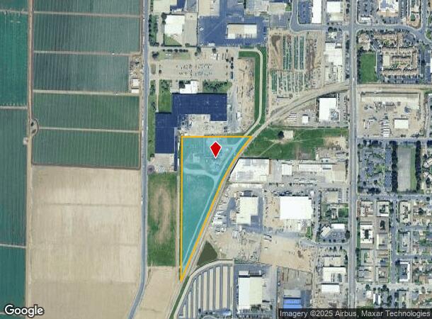
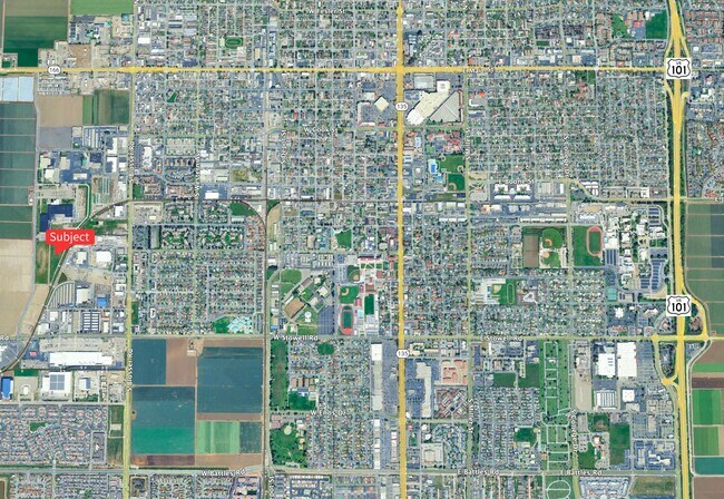
Property Record
802 Hanson Way, Santa Maria, CA 93458
This Property Is For Sale
NEARBY LISTINGS FOR SALE OR LEASE
Property Detail
802 Hanson Way
117-191-053
PARCEL MAPS 41 PG 75
Miscellaneous
Santa Barbara
X
California
06079C1905F
8.73 AC
2024
North SB County
2025
Santa Barbara/Sta Maria/Goleta
002410
Santa Maria-Santa Barbara, CA
DEMOGRAPHICS near 802 Hanson Way
1 Mile
3 Mile
5 Mile
2024 Total Population
15,630
99,158
123,628
2029 Population
15,424
97,965
121,965
Pop Growth 2024-2029
(1.32%)
(1.20%)
(1.35%)
Average Age
30
33
35
2024 Total Households
3,568
25,671
33,712
HH Growth 2024-2029
(1.49%)
(1.26%)
(1.43%)
Median Household Inc
$56,739
$78,835
$84,942
Avg Household Size
4.20
3.70
3.50
2024 Avg HH Vehicles
2.00
2.00
2.00
Median Home Value
$567,916
$531,209
$574,719
Median Year Built
1975
1979
1979
Nearby Places
- Restaurants
- Banks
- Shops
- Fitness
- Groceries
PUBLIC TRANSPORTATION
COMMUTER RAIL
Guadalupe Amtrak Station (Pacific Surfliner - Amtrak)
DRIVE
WALK
Distance
Guadalupe Amtrak Station (Pacific Surfliner - Amtrak)
14 min
8.3 mi
AIRPORT
San Luis County Regional
DRIVE
WALK
Distance
San Luis County Regional
42 min
27.3 mi
Freight Ports
The Port of Hueneme
DRIVE
WALK
Distance
The Port of Hueneme
138 min
103.5 mi
Nearby Properties
Address
Land Use
TOTAL SIZE
Lot Size
Zoning
Address
Land Use
TOTAL SIZE
Lot Size
Zoning
Address
Land Use
TOTAL SIZE
Lot Size
Zoning
211.15 AC
Address
Land Use
TOTAL SIZE
Lot Size
Zoning
49.99 AC
Address
Land Use
TOTAL SIZE
Lot Size
Zoning
14.45 AC
Address
Land Use
TOTAL SIZE
Lot Size
Zoning
146.75 AC
Address
Land Use
TOTAL SIZE
Lot Size
Zoning
6.35 AC
Address
Land Use
TOTAL SIZE
Lot Size
Zoning
9.46 AC
Address
Land Use
TOTAL SIZE
Lot Size
Zoning
18.19 AC
Address
Land Use
TOTAL SIZE
Lot Size
Zoning
Address
Land Use
TOTAL SIZE
Lot Size
Zoning
9.50 AC
Address
Land Use
TOTAL SIZE
Lot Size
Zoning
17.71 AC
Address
Land Use
TOTAL SIZE
Lot Size
Zoning
Address
Land Use
TOTAL SIZE
Lot Size
Zoning
Address
Land Use
TOTAL SIZE
Lot Size
Zoning
21.09 AC
Address
Land Use
TOTAL SIZE
Lot Size
Zoning
10.75 AC
Address
Land Use
TOTAL SIZE
Lot Size
Zoning
6.36 AC
Address
Land Use
TOTAL SIZE
Lot Size
Zoning
10.81 AC
Address
Land Use
TOTAL SIZE
Lot Size
Zoning
6.17 AC
Address
Land Use
TOTAL SIZE
Lot Size
Zoning
45.32 AC
Address
Land Use
TOTAL SIZE
Lot Size
Zoning
13.76 AC
Address
Land Use
TOTAL SIZE
Lot Size
Zoning
Address
Land Use
TOTAL SIZE
Lot Size
Zoning
Address
Land Use
TOTAL SIZE
Lot Size
Zoning
4.40 AC
Address
Land Use
TOTAL SIZE
Lot Size
Zoning
Address
Land Use
TOTAL SIZE
Lot Size
Zoning
27.05 AC
Address
Land Use
TOTAL SIZE
Lot Size
Zoning
Address
Land Use
TOTAL SIZE
Lot Size
Zoning
6.11 AC
Address
Land Use
TOTAL SIZE
Lot Size
Zoning
2.81 AC
Address
Land Use
TOTAL SIZE
Lot Size
Zoning
The World's #1 Commercial Real Estate Marketplace
Connect with us
© 2025 CoStar Group
The information above has been obtained from sources believed reliable. While we do not doubt its accuracy we have not verified it and make no guarantee, warranty or representation about it. It is your responsibility to independently confirm its accuracy and completeness. Any projections, opinions, assumptions, or estimates used are for example only and do not represent the current or future performance of the property. The value of this transaction to you depends on tax and other factors which should be evaluated by your tax, financial, and legal advisors. You and your advisors should conduct a careful, independent investigation of the property to determine to your satisfaction the suitability of the property for your needs.