Property Record
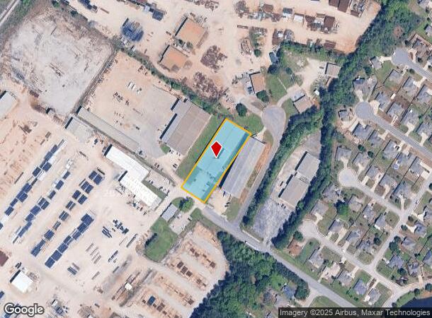
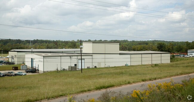
802 Labarge Dr, Bessemer, AL 35022

NEARBY LISTINGS FOR SALE OR LEASE
-
-
View all Bessemer listings for sale on LoopNet.com
Property Detail
802 Labarge Dr
38-00-29-3-001-001.109
COM NW COR OF SW 1/4 SEC 29 TP 19 R 4W TH E 281.1 FT TH SW 468.5 FT TH SE 1040.1 FT TO POB TH CONT 130.4 FT TH NE 376 FT TH NW 130.3 FT TH SW 375.8 FT TO POB
Warehouse
Jefferson
X
Alabama
01073C0676G
1.12 AC
2023
Bessemer
2024
Birmingham
014105
Birmingham-Hoover, AL
25,000 SF
DEMOGRAPHICS near 802 Labarge Dr
1 Mile
3 Mile
5 Mile
2024 Total Population
3,475
21,125
42,690
2029 Population
3,390
20,626
41,933
Pop Growth 2024-2029
(2.45%)
(2.36%)
(1.77%)
Average Age
40
40
40
2024 Total Households
1,387
8,433
16,969
HH Growth 2024-2029
(2.67%)
(2.55%)
(1.91%)
Median Household Inc
$64,700
$53,622
$50,165
Avg Household Size
2.40
2.40
2.40
2024 Avg HH Vehicles
2.00
2.00
2.00
Median Home Value
$205,213
$176,339
$175,092
Median Year Built
1999
1981
1976
Nearby Places
Map Layers
Map Styles
 Street
 Aerial
- Restaurants
- Banks
- Shops
- Fitness
- Groceries
PUBLIC TRANSPORTATION
AIRPORT
Birmingham-Shuttlesworth International
DRIVE
WALK
Distance
Birmingham-Shuttlesworth International
35 min
25.0 mi
Nearby Properties
Address
Land Use
TOTAL SIZE
Lot Size
Zoning
Address
Land Use
TOTAL SIZE
Lot Size
Zoning
1,740 SF
21 AC
A1/I
Address
Land Use
TOTAL SIZE
Lot Size
Zoning
857,420 SF
34.50 AC
I3
Address
Land Use
TOTAL SIZE
Lot Size
Zoning
184,428 SF
9.70 AC
01
Address
Land Use
TOTAL SIZE
Lot Size
Zoning
311,900 SF
30.20 AC
Address
Land Use
TOTAL SIZE
Lot Size
Zoning
526,350 SF
24.62 AC
I2
Address
Land Use
TOTAL SIZE
Lot Size
Zoning
178,953 SF
30 AC
C4
Address
Land Use
TOTAL SIZE
Lot Size
Zoning
210,815 SF
114 AC
I1-A
Address
Land Use
TOTAL SIZE
Lot Size
Zoning
47,705 SF
0.69 AC
01
Address
Land Use
TOTAL SIZE
Lot Size
Zoning
125,937 SF
7 AC
C4
Address
Land Use
TOTAL SIZE
Lot Size
Zoning
195,461 SF
15.03 AC
C3-R
Address
Land Use
TOTAL SIZE
Lot Size
Zoning
200,227 SF
25.10 AC
C-4
Address
Land Use
TOTAL SIZE
Lot Size
Zoning
175,224 SF
9.70 AC
R2
Address
Land Use
TOTAL SIZE
Lot Size
Zoning
38,868 SF
10.90 AC
C-4
Address
Land Use
TOTAL SIZE
Lot Size
Zoning
30,177 SF
2.45 AC
I
Address
Land Use
TOTAL SIZE
Lot Size
Zoning
100,050 SF
14 AC
C-4
Address
Land Use
TOTAL SIZE
Lot Size
Zoning
122,720 SF
6.77 AC
O1-R
Address
Land Use
TOTAL SIZE
Lot Size
Zoning
137,641 SF
26.80 AC
R4
Address
Land Use
TOTAL SIZE
Lot Size
Zoning
132,116 SF
9.15 AC
R3
Address
Land Use
TOTAL SIZE
Lot Size
Zoning
132,683 SF
16 AC
R-4
Address
Land Use
TOTAL SIZE
Lot Size
Zoning
83,450 SF
4.20 AC
C4
Address
Land Use
TOTAL SIZE
Lot Size
Zoning
63.30 AC
I3
Address
Land Use
TOTAL SIZE
Lot Size
Zoning
43,423 SF
8.16 AC
A1
Address
Land Use
TOTAL SIZE
Lot Size
Zoning
51,952 SF
6.24 AC
A1
Address
Land Use
TOTAL SIZE
Lot Size
Zoning
2.50 AC
C4
Address
Land Use
TOTAL SIZE
Lot Size
Zoning
25,182 SF
1.76 AC
C4
Address
Land Use
TOTAL SIZE
Lot Size
Zoning
38,376 SF
4.87 AC
C3
Address
Land Use
TOTAL SIZE
Lot Size
Zoning
47,284 SF
11.30 AC
0-1/
Address
Land Use
TOTAL SIZE
Lot Size
Zoning
23,264 SF
4.06 AC
C4
Address
Land Use
TOTAL SIZE
Lot Size
Zoning
54,036 SF
8.30 AC
C4
Address
Land Use
TOTAL SIZE
Lot Size
Zoning
45,959 SF
6.72 AC
C-4
The World's #1 Commercial Real Estate Marketplace
Connect with us
© 2025 CoStar Group
The information above has been obtained from sources believed reliable. While we do not doubt its accuracy we have not verified it and make no guarantee, warranty or representation about it. It is your responsibility to independently confirm its accuracy and completeness. Any projections, opinions, assumptions, or estimates used are for example only and do not represent the current or future performance of the property. The value of this transaction to you depends on tax and other factors which should be evaluated by your tax, financial, and legal advisors. You and your advisors should conduct a careful, independent investigation of the property to determine to your satisfaction the suitability of the property for your needs.