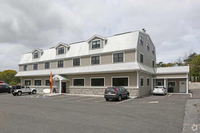
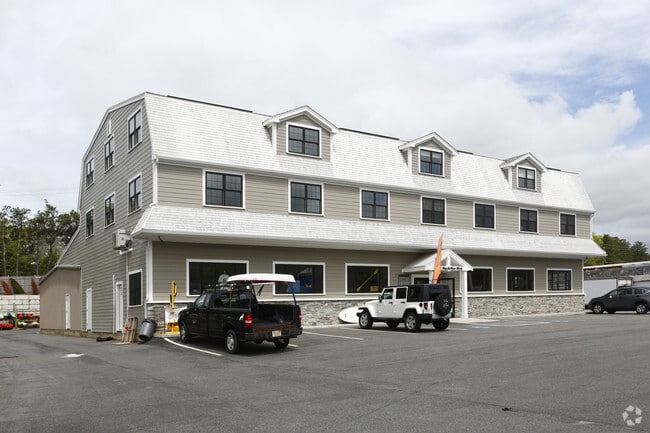
Property Record
802 Macarthur Blvd, Pocasset, MA 02559
Current Lease Availabilities
NEARBY LISTINGS FOR SALE OR LEASE
Property Detail
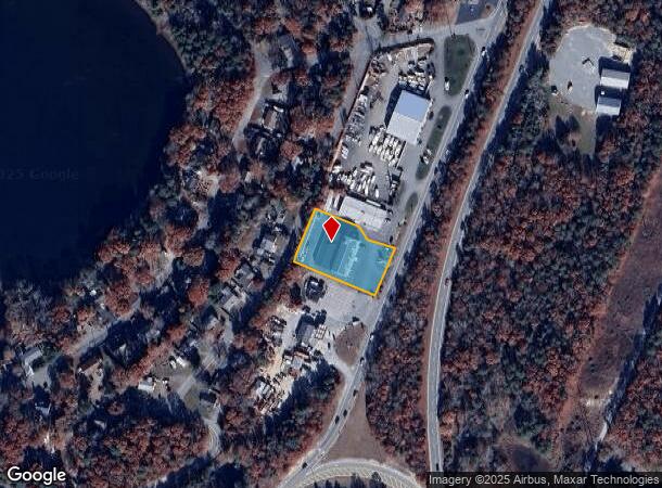
802 Macarthur Blvd
Officebuilding
Barnstable
X
Massachusetts
25001C0504J
0.81 AC
2025
Cape Cod
2025
Other Market Areas
014002
Barnstable Town, MA
18,544 SF
BOUR-000442-000000-000132
DEMOGRAPHICS near 802 Macarthur Blvd
1 mile
3 mile
5 mile
2024 Total Population
1,251
7,160
22,941
2029 Population
1,229
7,055
22,918
Pop Growth 2024-2029
(1.76%)
(1.47%)
(0.10%)
Average Age
49
48
47
2024 Total Households
606
3,132
9,401
HH Growth 2024-2029
(1.98%)
(2.14%)
(0.50%)
Median Household Inc
$77,885
$93,749
$88,766
Avg Household Size
2.00
2.20
2.20
2024 Avg HH Vehicles
2.00
2.00
2.00
Median Home Value
$415,644
$482,529
$487,130
Median Year Built
1981
1977
1976
Nearby Places
Map Layers
Map Styles
 Street
 Aerial
Transit
 Traffic
 Biking
Places
Listings with unknown addresses are not visible on the map
- Restaurants
- Banks
- Shops
- Fitness
- Groceries
PUBLIC TRANSPORTATION
AIRPORT
Martha's Vineyard
Drive
Walk
Distance
Martha's Vineyard
83 min
27.1 mi
Freight Ports
Port of New Bedford Harbor
Drive
Walk
Distance
Port of New Bedford Harbor
44 min
32.2 mi
Nearby Properties
Address
Land Use
TOTAL SIZE
Lot Size
Zoning
Address
Land Use
TOTAL SIZE
Lot Size
Zoning
22,000 SF
749.29 AC
GD
Address
Land Use
TOTAL SIZE
Lot Size
Zoning
73,483 SF
16.18 AC
Address
Land Use
TOTAL SIZE
Lot Size
Zoning
74.05 AC
B-3
Address
Land Use
TOTAL SIZE
Lot Size
Zoning
11.20 AC
Address
Land Use
TOTAL SIZE
Lot Size
Zoning
17.50 AC
Address
Land Use
TOTAL SIZE
Lot Size
Zoning
45.85 AC
Address
Land Use
TOTAL SIZE
Lot Size
Zoning
1,199 SF
3.70 AC
R40
Address
Land Use
TOTAL SIZE
Lot Size
Zoning
8,224 SF
1.10 AC
R40
Address
Land Use
TOTAL SIZE
Lot Size
Zoning
6,999 SF
2.84 AC
R40
Address
Land Use
TOTAL SIZE
Lot Size
Zoning
2.82 AC
Address
Land Use
TOTAL SIZE
Lot Size
Zoning
1,452 SF
6.70 AC
Address
Land Use
TOTAL SIZE
Lot Size
Zoning
6,460 SF
1.38 AC
RB
Address
Land Use
TOTAL SIZE
Lot Size
Zoning
15.80 AC
Address
Land Use
TOTAL SIZE
Lot Size
Zoning
11,262 SF
0.95 AC
R40
Address
Land Use
TOTAL SIZE
Lot Size
Zoning
Address
Land Use
TOTAL SIZE
Lot Size
Zoning
5,204 SF
1.17 AC
R40
Address
Land Use
TOTAL SIZE
Lot Size
Zoning
4.10 AC
R-80
Address
Land Use
TOTAL SIZE
Lot Size
Zoning
7,676 SF
2.69 AC
RB
Address
Land Use
TOTAL SIZE
Lot Size
Zoning
8.91 AC
R-80
Address
Land Use
TOTAL SIZE
Lot Size
Zoning
7,034 SF
1.11 AC
R40
Address
Land Use
TOTAL SIZE
Lot Size
Zoning
3,172 SF
2.23 AC
R40
Address
Land Use
TOTAL SIZE
Lot Size
Zoning
Address
Land Use
TOTAL SIZE
Lot Size
Zoning
1.41 AC
R40
Address
Land Use
TOTAL SIZE
Lot Size
Zoning
10.02 AC
R40
Address
Land Use
TOTAL SIZE
Lot Size
Zoning
5,597 SF
1.37 AC
R40
Address
Land Use
TOTAL SIZE
Lot Size
Zoning
1.56 AC
R40
Address
Land Use
TOTAL SIZE
Lot Size
Zoning
7,856 SF
5.34 AC
R40
Address
Land Use
TOTAL SIZE
Lot Size
Zoning
38,800 SF
5.24 AC
B-4
Address
Land Use
TOTAL SIZE
Lot Size
Zoning
4,827 SF
0.55 AC
R40
Address
Land Use
TOTAL SIZE
Lot Size
Zoning
7,552 SF
6.78 AC
R40
The World's #1 Commercial Real Estate Marketplace
Connect with us
© 2026 CoStar Group
The information above has been obtained from sources believed reliable. While we do not doubt its accuracy we have not verified it and make no guarantee, warranty or representation about it. It is your responsibility to independently confirm its accuracy and completeness. Any projections, opinions, assumptions, or estimates used are for example only and do not represent the current or future performance of the property. The value of this transaction to you depends on tax and other factors which should be evaluated by your tax, financial, and legal advisors. You and your advisors should conduct a careful, independent investigation of the property to determine to your satisfaction the suitability of the property for your needs.