Property Record
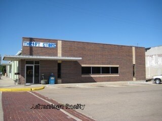
802 N Maple St, Russell, KS 67665

Property Detail
802 N Maple St
148-27-0-10-46-005.00-0
RUSSELL ORIGINAL TOWN, S27, T13, R14W, S76.5' LOTS 16-20 BLK 70 SECTION 27 TOWNSHIP 13 RANGE 14W
Officebuilding
Russell
C1
Kansas
0
16-20
2025
0.46 AC
973800
I-70 Corridor
7,980 SF
Other Market Areas
NEARBY LISTINGS FOR SALE OR LEASE
-
-
View all Russell listings for sale on LoopNet.com
DEMOGRAPHICS near 802 N Maple St
1 mile
3 mile
5 mile
2025 Total Population
4,311
4,776
4,852
2030 Population
4,330
4,800
4,872
Pop Growth 2025-2030
+ 0.44%
+ 0.50%
+ 0.41%
Average Age
43
43
43
2025 Total Households
1,893
2,103
2,135
HH Growth 2025-2030
+ 0.48%
+ 0.48%
+ 0.42%
Median Household Inc
$53,358
$54,677
$54,786
Avg Household Size
2.20
2.20
2.20
2025 Avg HH Vehicles
2.00
2.00
2.00
Median Home Value
$119,077
$123,171
$123,671
Median Year Built
1955
1955
1955
Nearby Places
Map Layers
Map Styles
 Street
 Aerial
Layers
 Traffic
 Biking
Places
Listings with unknown addresses are not visible on the map
- Restaurants
- Banks
- Shops
- Fitness
- Groceries
Nearby Properties
Address
Land Use
TOTAL SIZE
Lot Size
Zoning
Address
Land Use
TOTAL SIZE
Lot Size
Zoning
111,628 SF
54.70 AC
R2
Address
Land Use
TOTAL SIZE
Lot Size
Zoning
9,497 SF
5.40 AC
R2
Address
Land Use
TOTAL SIZE
Lot Size
Zoning
12,768 SF
3.20 AC
Address
Land Use
TOTAL SIZE
Lot Size
Zoning
4,960 SF
23.70 AC
Address
Land Use
TOTAL SIZE
Lot Size
Zoning
34,683 SF
8.35 AC
Address
Land Use
TOTAL SIZE
Lot Size
Zoning
2,232 SF
119.10 AC
Address
Land Use
TOTAL SIZE
Lot Size
Zoning
64,893 SF
3.20 AC
Address
Land Use
TOTAL SIZE
Lot Size
Zoning
4,182 SF
2.80 AC
I1
Address
Land Use
TOTAL SIZE
Lot Size
Zoning
3,192 SF
15.40 AC
Address
Land Use
TOTAL SIZE
Lot Size
Zoning
10,524 SF
0.41 AC
C2
Address
Land Use
TOTAL SIZE
Lot Size
Zoning
14,588 SF
5.50 AC
Address
Land Use
TOTAL SIZE
Lot Size
Zoning
14,176 SF
0.90 AC
C1
Address
Land Use
TOTAL SIZE
Lot Size
Zoning
8,556 SF
1.60 AC
Address
Land Use
TOTAL SIZE
Lot Size
Zoning
28,410 SF
3.20 AC
Address
Land Use
TOTAL SIZE
Lot Size
Zoning
26,248 SF
3.20 AC
Address
Land Use
TOTAL SIZE
Lot Size
Zoning
11,000 SF
1.10 AC
Address
Land Use
TOTAL SIZE
Lot Size
Zoning
5,873 SF
0.76 AC
C1
Address
Land Use
TOTAL SIZE
Lot Size
Zoning
11,187 SF
0.57 AC
C2
Address
Land Use
TOTAL SIZE
Lot Size
Zoning
6,059 SF
1.53 AC
Address
Land Use
TOTAL SIZE
Lot Size
Zoning
9,408 SF
4 AC
Address
Land Use
TOTAL SIZE
Lot Size
Zoning
9,837 SF
0.70 AC
Address
Land Use
TOTAL SIZE
Lot Size
Zoning
12,992 SF
2 AC
Address
Land Use
TOTAL SIZE
Lot Size
Zoning
11,520 SF
3.20 AC
Address
Land Use
TOTAL SIZE
Lot Size
Zoning
255.80 AC
Address
Land Use
TOTAL SIZE
Lot Size
Zoning
9,555 SF
0.76 AC
C1
Address
Land Use
TOTAL SIZE
Lot Size
Zoning
14,550 SF
20.18 AC
Address
Land Use
TOTAL SIZE
Lot Size
Zoning
12,745 SF
3.20 AC
Address
Land Use
TOTAL SIZE
Lot Size
Zoning
21,760 SF
6.80 AC
Address
Land Use
TOTAL SIZE
Lot Size
Zoning
40,088 SF
4.60 AC
C2
Address
Land Use
TOTAL SIZE
Lot Size
Zoning
5,000 SF
0.76 AC
C2
The World's #1 Commercial Real Estate Marketplace
Connect with us
© 2026 CoStar Group
The information above has been obtained from sources believed reliable. While we do not doubt its accuracy we have not verified it and make no guarantee, warranty or representation about it. It is your responsibility to independently confirm its accuracy and completeness. Any projections, opinions, assumptions, or estimates used are for example only and do not represent the current or future performance of the property. The value of this transaction to you depends on tax and other factors which should be evaluated by your tax, financial, and legal advisors. You and your advisors should conduct a careful, independent investigation of the property to determine to your satisfaction the suitability of the property for your needs.