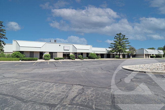
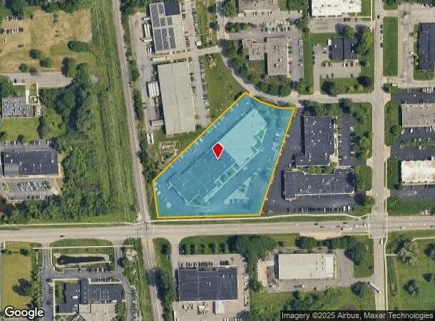
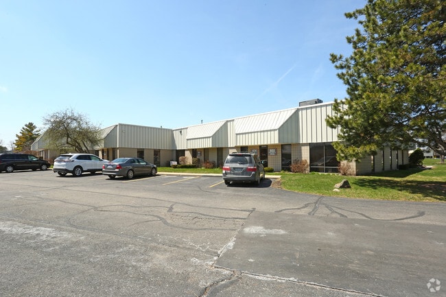
Property Record
802 Phoenix Dr, Ann Arbor, MI 48108
Current Lease Availabilities
NEARBY LISTINGS FOR SALE OR LEASE
Property Detail
802 Phoenix Dr
Ann Arbor, MI
Ann Arbor Industrial Park
12-09-400-020
LOT 26 ANN ARBOR INDUSTRIAL PARK
Commercialnec
Washtenaw
X
Michigan
26161C0401E
26
2025
4.10 AC
2025
Washtenaw W of 23
405600
Detroit
50,381 SF
DEMOGRAPHICS near 802 Phoenix Dr
1 Mile
3 Mile
5 Mile
2024 Total Population
4,985
62,251
167,717
2029 Population
4,895
61,517
165,798
Pop Growth 2024-2029
(1.81%)
(1.18%)
(1.14%)
Average Age
37
38
37
2024 Total Households
2,193
27,140
68,956
HH Growth 2024-2029
(1.82%)
(1.29%)
(1.16%)
Median Household Inc
$59,944
$85,302
$74,978
Avg Household Size
2.20
2.20
2.20
2024 Avg HH Vehicles
1.00
2.00
2.00
Median Home Value
$256,444
$393,259
$384,226
Median Year Built
1974
1980
1976
Nearby Places
Map Layers
Map Styles
 Street
 Aerial
- Restaurants
- Banks
- Shops
- Fitness
- Groceries
PUBLIC TRANSPORTATION
COMMUTER RAIL
DRIVE
WALK
Distance
13 min
5.1 mi
AIRPORT
Detroit Metro Wayne County
DRIVE
WALK
Distance
Detroit Metro Wayne County
35 min
26.2 mi
Nearby Properties
Address
Land Use
TOTAL SIZE
Lot Size
Zoning
Address
Land Use
TOTAL SIZE
Lot Size
Zoning
407,374 SF
35.17 AC
C3
Address
Land Use
TOTAL SIZE
Lot Size
Zoning
Address
Land Use
TOTAL SIZE
Lot Size
Zoning
315,108 SF
6.57 AC
C1B
Address
Land Use
TOTAL SIZE
Lot Size
Zoning
334,077 SF
20.41 AC
R4B
Address
Land Use
TOTAL SIZE
Lot Size
Zoning
357,978 SF
19.32 AC
R4B
Address
Land Use
TOTAL SIZE
Lot Size
Zoning
140,670 SF
1.63 AC
C2B
Address
Land Use
TOTAL SIZE
Lot Size
Zoning
112,994 SF
45.12 AC
IH
Address
Land Use
TOTAL SIZE
Lot Size
Zoning
140,039 SF
Address
Land Use
TOTAL SIZE
Lot Size
Zoning
271,521 SF
15.11 AC
Address
Land Use
TOTAL SIZE
Lot Size
Zoning
127,076 SF
0.39 AC
D1
Address
Land Use
TOTAL SIZE
Lot Size
Zoning
214,559 SF
16.18 AC
PUD
Address
Land Use
TOTAL SIZE
Lot Size
Zoning
268,002 SF
18.34 AC
Address
Land Use
TOTAL SIZE
Lot Size
Zoning
234,076 SF
24.18 AC
R4A
Address
Land Use
TOTAL SIZE
Lot Size
Zoning
253,702 SF
30.23 AC
Address
Land Use
TOTAL SIZE
Lot Size
Zoning
1.19 AC
R4C
Address
Land Use
TOTAL SIZE
Lot Size
Zoning
32,040 SF
22.33 AC
BI
Address
Land Use
TOTAL SIZE
Lot Size
Zoning
111,435 SF
21.38 AC
R4B
Address
Land Use
TOTAL SIZE
Lot Size
Zoning
175,536 SF
12.98 AC
R4B
Address
Land Use
TOTAL SIZE
Lot Size
Zoning
119,631 SF
7.85 AC
PUD
Address
Land Use
TOTAL SIZE
Lot Size
Zoning
88,460 SF
28.50 AC
DI
Address
Land Use
TOTAL SIZE
Lot Size
Zoning
192,726 SF
6.45 AC
O
Address
Land Use
TOTAL SIZE
Lot Size
Zoning
283,290 SF
10.42 AC
O
Address
Land Use
TOTAL SIZE
Lot Size
Zoning
137,182 SF
11.83 AC
R4C
Address
Land Use
TOTAL SIZE
Lot Size
Zoning
317,872 SF
11.79 AC
M1
Address
Land Use
TOTAL SIZE
Lot Size
Zoning
94,157 SF
7.20 AC
C3
Address
Land Use
TOTAL SIZE
Lot Size
Zoning
18,148 SF
21.62 AC
BI
Address
Land Use
TOTAL SIZE
Lot Size
Zoning
116,850 SF
5.27 AC
O
Address
Land Use
TOTAL SIZE
Lot Size
Zoning
167,294 SF
40.67 AC
Address
Land Use
TOTAL SIZE
Lot Size
Zoning
159,558 SF
10.59 AC
R4B
Address
Land Use
TOTAL SIZE
Lot Size
Zoning
129,872 SF
3.46 AC
R3
The World's #1 Commercial Real Estate Marketplace
Connect with us
© 2026 CoStar Group
The information above has been obtained from sources believed reliable. While we do not doubt its accuracy we have not verified it and make no guarantee, warranty or representation about it. It is your responsibility to independently confirm its accuracy and completeness. Any projections, opinions, assumptions, or estimates used are for example only and do not represent the current or future performance of the property. The value of this transaction to you depends on tax and other factors which should be evaluated by your tax, financial, and legal advisors. You and your advisors should conduct a careful, independent investigation of the property to determine to your satisfaction the suitability of the property for your needs.