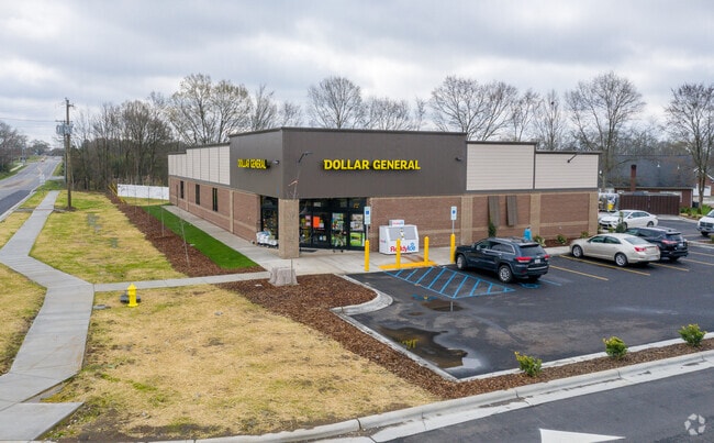
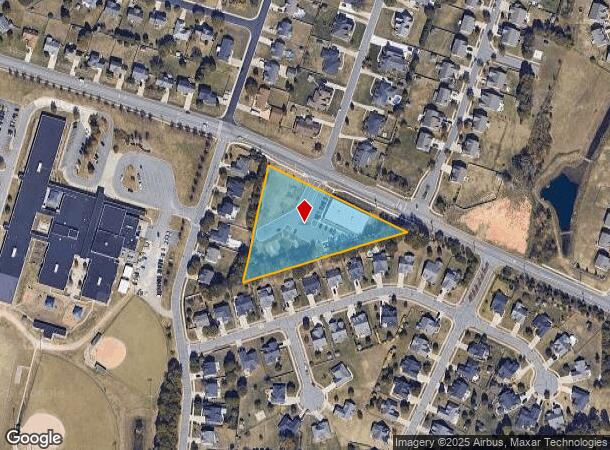
Property Record
802 Pitts School Rd Sw, Concord, NC 28027
NEARBY LISTINGS FOR SALE OR LEASE
Property Detail
802 Pitts School Rd Sw
5508-93-7949-0000
Concord Parkway South
Storebuilding
TERAMORE DEVELOPMENT LLC 2.095 AC
X
Cabarrus
3710551800K
North Carolina
2025
2.10 AC
2025
Cabarrus County
042603
Charlotte
9,372 SF
Charlotte-Concord-Gastonia, NC-SC
DEMOGRAPHICS near 802 Pitts School Rd Sw
1 Mile
3 Mile
5 Mile
2024 Total Population
6,325
29,936
116,645
2029 Population
7,064
33,499
129,239
Pop Growth 2024-2029
+ 11.68%
+ 11.90%
+ 10.80%
Average Age
39
38
37
2024 Total Households
2,288
10,531
41,991
HH Growth 2024-2029
+ 10.36%
+ 10.50%
+ 9.68%
Median Household Inc
$96,554
$100,235
$86,405
Avg Household Size
2.70
2.80
2.70
2024 Avg HH Vehicles
2.00
2.00
2.00
Median Home Value
$270,883
$288,369
$291,519
Median Year Built
2001
2000
2001
Nearby Places
Map Layers
Map Styles
 Street
 Aerial
- Restaurants
- Banks
- Shops
- Fitness
- Groceries
PUBLIC TRANSPORTATION
AIRPORT
Concord-Padgett Regional
DRIVE
WALK
Distance
Concord-Padgett Regional
18 min
8.6 mi
Charlotte/Douglas International
DRIVE
WALK
Distance
Charlotte/Douglas International
40 min
24.3 mi
Freight Ports
Port of Wilmington
DRIVE
WALK
Distance
Port of Wilmington
258 min
203.6 mi
SALE & LEASE HISTORY
LISTING DATE
SALE/LEASE

Sep 23, 2019
For Sale
Nearby Properties
Address
Land Use
TOTAL SIZE
Lot Size
Zoning
Address
Land Use
TOTAL SIZE
Lot Size
Zoning
154,304 SF
857.72 AC
PID
Address
Land Use
TOTAL SIZE
Lot Size
Zoning
33,090 SF
19.43 AC
C-2
Address
Land Use
TOTAL SIZE
Lot Size
Zoning
5,048 SF
26.66 AC
C-2
Address
Land Use
TOTAL SIZE
Lot Size
Zoning
495.38 AC
I-2
Address
Land Use
TOTAL SIZE
Lot Size
Zoning
196,893 SF
43.82 AC
MDR
Address
Land Use
TOTAL SIZE
Lot Size
Zoning
226,355 SF
99.26 AC
O-I
Address
Land Use
TOTAL SIZE
Lot Size
Zoning
163,494 SF
89.85 AC
I-2
Address
Land Use
TOTAL SIZE
Lot Size
Zoning
350,339 SF
77.60 AC
RM-1
Address
Land Use
TOTAL SIZE
Lot Size
Zoning
7,566 SF
19.98 AC
RC
Address
Land Use
TOTAL SIZE
Lot Size
Zoning
175,978 SF
63.81 AC
O-I
Address
Land Use
TOTAL SIZE
Lot Size
Zoning
6,539 SF
173.17 AC
LI
Address
Land Use
TOTAL SIZE
Lot Size
Zoning
21,714 SF
15.02 AC
RC
Address
Land Use
TOTAL SIZE
Lot Size
Zoning
152,554 SF
29.94 AC
O-I
Address
Land Use
TOTAL SIZE
Lot Size
Zoning
360,400 SF
20.32 AC
EC
Address
Land Use
TOTAL SIZE
Lot Size
Zoning
125,245 SF
21.47 AC
O-I
Address
Land Use
TOTAL SIZE
Lot Size
Zoning
304,000 SF
17.30 AC
EC
Address
Land Use
TOTAL SIZE
Lot Size
Zoning
160,357 SF
26.85 AC
O-I
Address
Land Use
TOTAL SIZE
Lot Size
Zoning
4,588 SF
550.66 AC
I-2
Address
Land Use
TOTAL SIZE
Lot Size
Zoning
209,420 SF
32.12 AC
EC
Address
Land Use
TOTAL SIZE
Lot Size
Zoning
123,800 SF
43.87 AC
CUI-1
Address
Land Use
TOTAL SIZE
Lot Size
Zoning
184,784 SF
16.30 AC
I-1
Address
Land Use
TOTAL SIZE
Lot Size
Zoning
48,888 SF
15.29 AC
GC
Address
Land Use
TOTAL SIZE
Lot Size
Zoning
14,553 SF
313.23 AC
C-2
Address
Land Use
TOTAL SIZE
Lot Size
Zoning
12,486 SF
232.04 AC
O-I
Address
Land Use
TOTAL SIZE
Lot Size
Zoning
174,732 SF
29.05 AC
LI
Address
Land Use
TOTAL SIZE
Lot Size
Zoning
123.07 AC
CD
Address
Land Use
TOTAL SIZE
Lot Size
Zoning
8,656 SF
10.01 AC
RC
Address
Land Use
TOTAL SIZE
Lot Size
Zoning
54,503 SF
9.32 AC
EC
Address
Land Use
TOTAL SIZE
Lot Size
Zoning
12,150 SF
7.23 AC
GI
Address
Land Use
TOTAL SIZE
Lot Size
Zoning
13,410 SF
9.40 AC
O-I
The World's #1 Commercial Real Estate Marketplace
Connect with us
© 2025 CoStar Group
The information above has been obtained from sources believed reliable. While we do not doubt its accuracy we have not verified it and make no guarantee, warranty or representation about it. It is your responsibility to independently confirm its accuracy and completeness. Any projections, opinions, assumptions, or estimates used are for example only and do not represent the current or future performance of the property. The value of this transaction to you depends on tax and other factors which should be evaluated by your tax, financial, and legal advisors. You and your advisors should conduct a careful, independent investigation of the property to determine to your satisfaction the suitability of the property for your needs.