Property Record
802 Walsh Rd, Madison, WI 53714
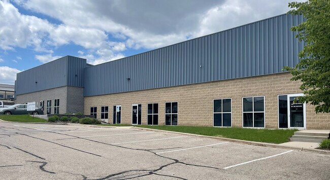

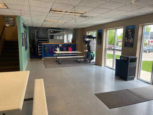
Property Detail
802 Walsh Rd
0810-334-0517-8
CERTIFIED SURVEY MAP NO 10696 RECORDED IN DANE COUNTY REGISTER OF DEEDS IN VOLUM E 63 PAGE 265 OF CERTIFIED SURVEYS, LOT 1.
Commercialnec
Dane
IL
Wisconsin
B and X Area of moderate flood hazard, usually the area between the limits of the 100-year and 500-year floods.
1
2025
1.90 AC
2025
Northeast Madison
002603
Milwaukee/Madison
7,710 SF
Madison, WI
NEARBY LISTINGS FOR SALE OR LEASE
DEMOGRAPHICS near 802 Walsh Rd
1 mile
3 mile
5 mile
2025 Total Population
8,135
67,857
135,409
2030 Population
8,295
70,461
140,119
Pop Growth 2025-2030
+ 1.97%
+ 3.84%
+ 3.48%
Average Age
39
40
38
2025 Total Households
3,578
31,791
64,103
HH Growth 2025-2030
+ 2.21%
+ 4.19%
+ 3.81%
Median Household Inc
$62,092
$76,974
$70,827
Avg Household Size
2.20
2.10
2.00
2025 Avg HH Vehicles
1.00
2.00
1.00
Median Home Value
$289,965
$321,241
$339,849
Median Year Built
1975
1973
1976
Nearby Places
Map Layers
Map Styles
 Street
 Aerial
Layers
 Traffic
 Biking
Places
Listings with unknown addresses are not visible on the map
- Restaurants
- Banks
- Shops
- Fitness
- Groceries
PUBLIC TRANSPORTATION
AIRPORT
Dane County Regional/Truax Field
Drive
Walk
Distance
Dane County Regional/Truax Field
9 min
4.1 mi
SALE & LEASE HISTORY
LISTING DATE
SALE/LEASE

May 15, 2018
For Lease
Mar 12, 2019
For Lease
Jun 01, 2022
For Lease
Nearby Properties
Address
Land Use
TOTAL SIZE
Lot Size
Zoning
Address
Land Use
TOTAL SIZE
Lot Size
Zoning
287,341 SF
40.17 AC
IL
Address
Land Use
TOTAL SIZE
Lot Size
Zoning
461,594 SF
3.37 AC
CC-T
Address
Land Use
TOTAL SIZE
Lot Size
Zoning
278,154 SF
3.88 AC
TE
Address
Land Use
TOTAL SIZE
Lot Size
Zoning
289,884 SF
19.36 AC
SR-V2
Address
Land Use
TOTAL SIZE
Lot Size
Zoning
50,400 SF
5.74 AC
SE
Address
Land Use
TOTAL SIZE
Lot Size
Zoning
222,830 SF
6.86 AC
TR-U1
Address
Land Use
TOTAL SIZE
Lot Size
Zoning
237,832 SF
CC
Address
Land Use
TOTAL SIZE
Lot Size
Zoning
266,955 SF
12.77 AC
PD
Address
Land Use
TOTAL SIZE
Lot Size
Zoning
216,017 SF
3.35 AC
TE
Address
Land Use
TOTAL SIZE
Lot Size
Zoning
286,104 SF
19.47 AC
SR-V2
Address
Land Use
TOTAL SIZE
Lot Size
Zoning
20,965 SF
10.98 AC
IL
Address
Land Use
TOTAL SIZE
Lot Size
Zoning
547,019 SF
29.06 AC
RMX
Address
Land Use
TOTAL SIZE
Lot Size
Zoning
166,108 SF
2 AC
WP-25
Address
Land Use
TOTAL SIZE
Lot Size
Zoning
156,054 SF
9.40 AC
SE
Address
Land Use
TOTAL SIZE
Lot Size
Zoning
103,769 SF
11.21 AC
WP-15
Address
Land Use
TOTAL SIZE
Lot Size
Zoning
176,088 SF
6.29 AC
PD
Address
Land Use
TOTAL SIZE
Lot Size
Zoning
109,450 SF
4.33 AC
TR-U1
Address
Land Use
TOTAL SIZE
Lot Size
Zoning
109,396 SF
3 AC
PD
Address
Land Use
TOTAL SIZE
Lot Size
Zoning
113,483 SF
4.61 AC
CC
Address
Land Use
TOTAL SIZE
Lot Size
Zoning
101,348 SF
6.37 AC
SEC
Address
Land Use
TOTAL SIZE
Lot Size
Zoning
63,081 SF
3.36 AC
PD
Address
Land Use
TOTAL SIZE
Lot Size
Zoning
102,649 SF
6.76 AC
SEC
Address
Land Use
TOTAL SIZE
Lot Size
Zoning
131,000 SF
4.51 AC
WP-25
Address
Land Use
TOTAL SIZE
Lot Size
Zoning
149,897 SF
17.72 AC
IL
Address
Land Use
TOTAL SIZE
Lot Size
Zoning
191,145 SF
12.24 AC
SR-V2
Address
Land Use
TOTAL SIZE
Lot Size
Zoning
150,439 SF
4.71 AC
CC-T
Address
Land Use
TOTAL SIZE
Lot Size
Zoning
131,307 SF
1.21 AC
PD
Address
Land Use
TOTAL SIZE
Lot Size
Zoning
87,541 SF
1.85 AC
TR-U2
Address
Land Use
TOTAL SIZE
Lot Size
Zoning
134,088 SF
6.45 AC
PD
Address
Land Use
TOTAL SIZE
Lot Size
Zoning
105,743 SF
9.50 AC
IG
The World's #1 Commercial Real Estate Marketplace
Connect with us
© 2026 CoStar Group
The information above has been obtained from sources believed reliable. While we do not doubt its accuracy we have not verified it and make no guarantee, warranty or representation about it. It is your responsibility to independently confirm its accuracy and completeness. Any projections, opinions, assumptions, or estimates used are for example only and do not represent the current or future performance of the property. The value of this transaction to you depends on tax and other factors which should be evaluated by your tax, financial, and legal advisors. You and your advisors should conduct a careful, independent investigation of the property to determine to your satisfaction the suitability of the property for your needs.