Property Record
802 Walton Dr, Texarkana, TX 75501


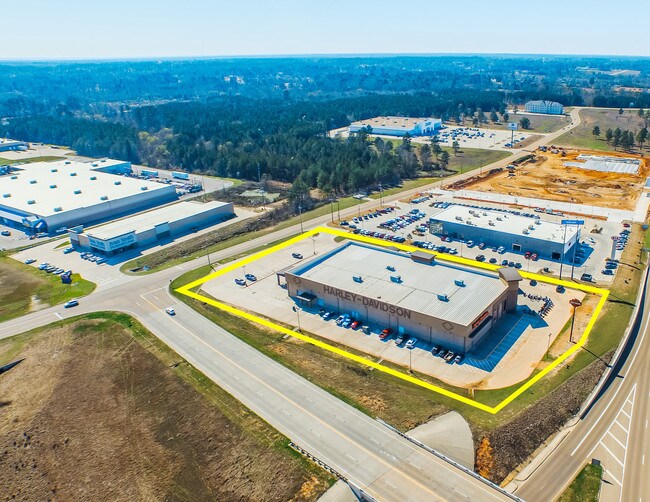
Property Detail
802 Walton Dr
Texarkana, TX-AR
WAL-MART SECOND ADDN REPLAT PORTION LOT 3 BLK 1 LOT 3E 2025-4145 04/30/25 BLK/TRACT 1 3.274 ACRES
86692
BOWIE
Commercialnec
Texas
B and X Area of moderate flood hazard, usually the area between the limits of the 100-year and 500-year floods.
3,3e
2024
3.27 AC
2025
Texas East Area
010905
Other Market Areas
34,817 SF
NEARBY LISTINGS FOR SALE OR LEASE
DEMOGRAPHICS near 802 Walton Dr
1 mile
3 mile
5 mile
2025 Total Population
2,757
36,198
71,649
2030 Population
2,778
36,007
71,259
Pop Growth 2025-2030
+ 0.76%
(0.53%)
(0.54%)
Average Age
37
39
39
2025 Total Households
1,206
14,767
28,269
HH Growth 2025-2030
+ 0.83%
(0.53%)
(0.58%)
Median Household Inc
$54,666
$51,512
$49,028
Avg Household Size
2.20
2.40
2.30
2025 Avg HH Vehicles
2.00
2.00
2.00
Median Home Value
$141,008
$164,668
$156,093
Median Year Built
1986
1982
1980
Nearby Places
Map Layers
Map Styles
 Street
 Aerial
Layers
 Traffic
 Biking
Places
Listings with unknown addresses are not visible on the map
- Restaurants
- Banks
- Shops
- Fitness
- Groceries
PUBLIC TRANSPORTATION
COMMUTER RAIL
Drive
Walk
Distance
9 min
4.6 mi
AIRPORT
Texarkana Regional-Webb Field
Drive
Walk
Distance
Texarkana Regional-Webb Field
19 min
8.6 mi
SALE & LEASE HISTORY
LISTING DATE
SALE/LEASE

Sep 22, 2017
For Sale
Apr 12, 2019
For Sale
Apr 12, 2017
For Sale
Nearby Properties
Address
Land Use
TOTAL SIZE
Lot Size
Zoning
Address
Land Use
TOTAL SIZE
Lot Size
Zoning
37.76 AC
Address
Land Use
TOTAL SIZE
Lot Size
Zoning
594,669 SF
26.19 AC
Address
Land Use
TOTAL SIZE
Lot Size
Zoning
415,000 SF
56.08 AC
Address
Land Use
TOTAL SIZE
Lot Size
Zoning
22.35 AC
Address
Land Use
TOTAL SIZE
Lot Size
Zoning
Address
Land Use
TOTAL SIZE
Lot Size
Zoning
Address
Land Use
TOTAL SIZE
Lot Size
Zoning
162,169 SF
19.18 AC
Address
Land Use
TOTAL SIZE
Lot Size
Zoning
133,136 SF
5.80 AC
Address
Land Use
TOTAL SIZE
Lot Size
Zoning
11.66 AC
Address
Land Use
TOTAL SIZE
Lot Size
Zoning
3,642 SF
24.74 AC
Address
Land Use
TOTAL SIZE
Lot Size
Zoning
11,320 SF
142 AC
Address
Land Use
TOTAL SIZE
Lot Size
Zoning
246,136 SF
15.50 AC
Address
Land Use
TOTAL SIZE
Lot Size
Zoning
97,914 SF
3.01 AC
Address
Land Use
TOTAL SIZE
Lot Size
Zoning
155,401 SF
15.01 AC
Address
Land Use
TOTAL SIZE
Lot Size
Zoning
130,000 SF
10.18 AC
Address
Land Use
TOTAL SIZE
Lot Size
Zoning
2.07 AC
Address
Land Use
TOTAL SIZE
Lot Size
Zoning
73,675 SF
4.44 AC
Address
Land Use
TOTAL SIZE
Lot Size
Zoning
67,800 SF
14.99 AC
Address
Land Use
TOTAL SIZE
Lot Size
Zoning
8.19 AC
Address
Land Use
TOTAL SIZE
Lot Size
Zoning
101,354 SF
33.83 AC
Address
Land Use
TOTAL SIZE
Lot Size
Zoning
533,299 SF
50.60 AC
Address
Land Use
TOTAL SIZE
Lot Size
Zoning
107,400 SF
5.83 AC
Address
Land Use
TOTAL SIZE
Lot Size
Zoning
100,327 SF
Address
Land Use
TOTAL SIZE
Lot Size
Zoning
51,587 SF
6.44 AC
Address
Land Use
TOTAL SIZE
Lot Size
Zoning
166,777 SF
9 AC
Address
Land Use
TOTAL SIZE
Lot Size
Zoning
87,452 SF
2.32 AC
Address
Land Use
TOTAL SIZE
Lot Size
Zoning
190,026 SF
30.86 AC
Address
Land Use
TOTAL SIZE
Lot Size
Zoning
62,256 SF
9.67 AC
Address
Land Use
TOTAL SIZE
Lot Size
Zoning
101,980 SF
5 AC
Address
Land Use
TOTAL SIZE
Lot Size
Zoning
82,125 SF
13.71 AC
The World's #1 Commercial Real Estate Marketplace
Connect with us
© 2026 CoStar Group
The information above has been obtained from sources believed reliable. While we do not doubt its accuracy we have not verified it and make no guarantee, warranty or representation about it. It is your responsibility to independently confirm its accuracy and completeness. Any projections, opinions, assumptions, or estimates used are for example only and do not represent the current or future performance of the property. The value of this transaction to you depends on tax and other factors which should be evaluated by your tax, financial, and legal advisors. You and your advisors should conduct a careful, independent investigation of the property to determine to your satisfaction the suitability of the property for your needs.