Property Record
802 White Pond Rd, Elgin, SC 29045
NEARBY LISTINGS FOR SALE OR LEASE
-
-
View all Elgin listings for sale on LoopNet.com
Property Detail
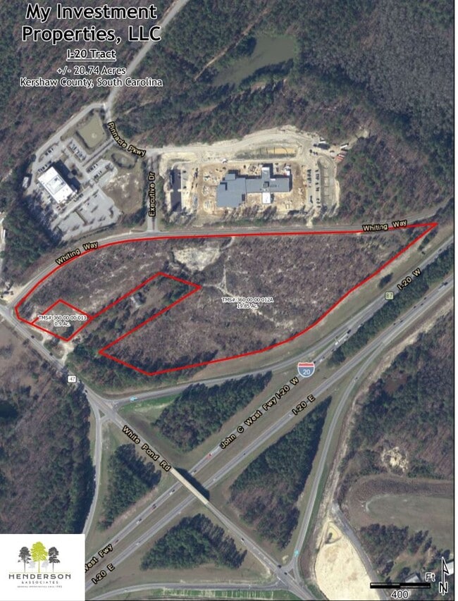
802 White Pond Rd
360-00-00-013
IV-2336 1024
Residentialacreage
Kershaw
X
South Carolina
45055C0419F
0.90 AC
2025
Kershaw County
2025
Columbia
970906
Columbia, SC
480 SF
DEMOGRAPHICS near 802 White Pond Rd
1 Mile
3 Mile
5 Mile
2024 Total Population
1,010
8,201
24,161
2029 Population
1,093
8,881
26,059
Pop Growth 2024-2029
+ 8.22%
+ 8.29%
+ 7.86%
Average Age
39
39
39
2024 Total Households
373
3,024
8,965
HH Growth 2024-2029
+ 8.04%
+ 8.13%
+ 7.80%
Median Household Inc
$81,041
$67,325
$66,781
Avg Household Size
2.70
2.70
2.60
2024 Avg HH Vehicles
2.00
2.00
2.00
Median Home Value
$169,108
$154,286
$179,660
Median Year Built
1995
1999
2001
Nearby Places
Map Layers
Map Styles
 Street
 Aerial
- Restaurants
- Banks
- Shops
- Fitness
- Groceries
PUBLIC TRANSPORTATION
AIRPORT
Columbia Metro
DRIVE
WALK
Distance
Columbia Metro
48 min
31.9 mi
Freight Ports
North Charleston Terminal
DRIVE
WALK
Distance
North Charleston Terminal
143 min
125.3 mi
Nearby Properties
Address
Land Use
TOTAL SIZE
Lot Size
Zoning
Address
Land Use
TOTAL SIZE
Lot Size
Zoning
47,081 SF
8.67 AC
Address
Land Use
TOTAL SIZE
Lot Size
Zoning
84,840 SF
5.19 AC
B2
Address
Land Use
TOTAL SIZE
Lot Size
Zoning
38,000 SF
9.71 AC
B2
Address
Land Use
TOTAL SIZE
Lot Size
Zoning
40,603 SF
4.64 AC
MUNICIPAL
Address
Land Use
TOTAL SIZE
Lot Size
Zoning
2,134 SF
179.51 AC
RU
Address
Land Use
TOTAL SIZE
Lot Size
Zoning
16,898 SF
61.26 AC
RD2
Address
Land Use
TOTAL SIZE
Lot Size
Zoning
926 SF
208.36 AC
RU
Address
Land Use
TOTAL SIZE
Lot Size
Zoning
61.32 AC
I1
Address
Land Use
TOTAL SIZE
Lot Size
Zoning
2,583 SF
1.24 AC
MUNICIPAL
Address
Land Use
TOTAL SIZE
Lot Size
Zoning
129.82 AC
RD2
Address
Land Use
TOTAL SIZE
Lot Size
Zoning
14,550 SF
2.02 AC
MUNICIPAL
Address
Land Use
TOTAL SIZE
Lot Size
Zoning
7,366 SF
0.52 AC
MUNICIPAL
Address
Land Use
TOTAL SIZE
Lot Size
Zoning
2,651 SF
0.95 AC
MUNICIPAL
Address
Land Use
TOTAL SIZE
Lot Size
Zoning
52.67 AC
Address
Land Use
TOTAL SIZE
Lot Size
Zoning
99.90 AC
RD2
Address
Land Use
TOTAL SIZE
Lot Size
Zoning
6,650 SF
1.19 AC
MUNICIPAL
Address
Land Use
TOTAL SIZE
Lot Size
Zoning
3,512 SF
0.83 AC
MUNICIPAL
Address
Land Use
TOTAL SIZE
Lot Size
Zoning
4,680 SF
7.54 AC
I1
Address
Land Use
TOTAL SIZE
Lot Size
Zoning
6,976 SF
80.16 AC
RD2
Address
Land Use
TOTAL SIZE
Lot Size
Zoning
19,900 SF
3.02 AC
GD
Address
Land Use
TOTAL SIZE
Lot Size
Zoning
17,899 SF
3.20 AC
I1
Address
Land Use
TOTAL SIZE
Lot Size
Zoning
4.20 AC
MUNICIPAL
Address
Land Use
TOTAL SIZE
Lot Size
Zoning
14.84 AC
GD
Address
Land Use
TOTAL SIZE
Lot Size
Zoning
3,120 SF
0.92 AC
MUNICIPAL
Address
Land Use
TOTAL SIZE
Lot Size
Zoning
13,500 SF
1.06 AC
GD
Address
Land Use
TOTAL SIZE
Lot Size
Zoning
2,865 SF
2.91 AC
B2
Address
Land Use
TOTAL SIZE
Lot Size
Zoning
11,500 SF
1.11 AC
MUNICIPAL
Address
Land Use
TOTAL SIZE
Lot Size
Zoning
7,722 SF
0.68 AC
Address
Land Use
TOTAL SIZE
Lot Size
Zoning
3,547 SF
0.83 AC
B2
Address
Land Use
TOTAL SIZE
Lot Size
Zoning
13,680 SF
2.96 AC
B2
The World's #1 Commercial Real Estate Marketplace
Connect with us
© 2026 CoStar Group
The information above has been obtained from sources believed reliable. While we do not doubt its accuracy we have not verified it and make no guarantee, warranty or representation about it. It is your responsibility to independently confirm its accuracy and completeness. Any projections, opinions, assumptions, or estimates used are for example only and do not represent the current or future performance of the property. The value of this transaction to you depends on tax and other factors which should be evaluated by your tax, financial, and legal advisors. You and your advisors should conduct a careful, independent investigation of the property to determine to your satisfaction the suitability of the property for your needs.