Property Record
8020 E Us Highway 24, Manhattan, KS 66502
NEARBY LISTINGS FOR SALE OR LEASE
Property Detail
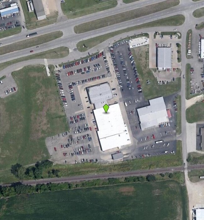
8020 E Us Highway 24
312-09-0-30-02-001.00-0
S09, T10, R08, ACRES 4.1, BEG INTER S LI HWY 24 & W LI E NOCH LN TH S698' SW263' N675' NE287' TO POB (SCALED MEAS)
Warehouse
Pottawatomie
AE
Kansas
20149C0460F
4.10 AC
2024
Kansas Area
2025
Other Market Areas
000102
Manhattan, KS
18,225 SF
DEMOGRAPHICS near 8020 E Us Highway 24
1 Mile
3 Mile
5 Mile
2024 Total Population
496
26,368
52,955
2029 Population
545
26,872
53,603
Pop Growth 2024-2029
+ 9.88%
+ 1.91%
+ 1.22%
Average Age
35
31
32
2024 Total Households
170
10,527
20,728
HH Growth 2024-2029
+ 10.00%
+ 1.53%
+ 1.02%
Median Household Inc
$102,500
$45,717
$52,264
Avg Household Size
2.80
2.20
2.20
2024 Avg HH Vehicles
2.00
2.00
2.00
Median Home Value
$243,529
$182,771
$214,819
Median Year Built
2001
1980
1980
Nearby Places
Map Layers
Map Styles
 Street
 Aerial
- Restaurants
- Banks
- Shops
- Fitness
- Groceries
PUBLIC TRANSPORTATION
AIRPORT
Manhattan Regional
DRIVE
WALK
Distance
Manhattan Regional
21 min
11.2 mi
Freight Ports
Tulsa Port Of Catoosa
DRIVE
WALK
Distance
Tulsa Port Of Catoosa
332 min
279.6 mi
Nearby Properties
Address
Land Use
TOTAL SIZE
Lot Size
Zoning
Address
Land Use
TOTAL SIZE
Lot Size
Zoning
45.61 AC
U
Address
Land Use
TOTAL SIZE
Lot Size
Zoning
1,084,753 SF
69.85 AC
U
Address
Land Use
TOTAL SIZE
Lot Size
Zoning
13,351 SF
23.80 AC
R1
Address
Land Use
TOTAL SIZE
Lot Size
Zoning
77,295 SF
4.30 AC
U
Address
Land Use
TOTAL SIZE
Lot Size
Zoning
95,188 SF
6.34 AC
R1
Address
Land Use
TOTAL SIZE
Lot Size
Zoning
29,816 SF
2.09 AC
C4
Address
Land Use
TOTAL SIZE
Lot Size
Zoning
126,616 SF
28.60 AC
R1
Address
Land Use
TOTAL SIZE
Lot Size
Zoning
66,076 SF
19.64 AC
Address
Land Use
TOTAL SIZE
Lot Size
Zoning
40,076 SF
1.27 AC
PUD
Address
Land Use
TOTAL SIZE
Lot Size
Zoning
46,653 SF
0.85 AC
U
Address
Land Use
TOTAL SIZE
Lot Size
Zoning
34,319 SF
1.77 AC
C1
Address
Land Use
TOTAL SIZE
Lot Size
Zoning
72,326 SF
4.83 AC
R
Address
Land Use
TOTAL SIZE
Lot Size
Zoning
9,754 SF
2 AC
PUD
Address
Land Use
TOTAL SIZE
Lot Size
Zoning
50,784 SF
2.66 AC
U
Address
Land Use
TOTAL SIZE
Lot Size
Zoning
33,829 SF
2.80 AC
R1
Address
Land Use
TOTAL SIZE
Lot Size
Zoning
46,655 SF
3.46 AC
Address
Land Use
TOTAL SIZE
Lot Size
Zoning
40,658 SF
2.89 AC
RM
Address
Land Use
TOTAL SIZE
Lot Size
Zoning
43,272 SF
2.89 AC
RM
Address
Land Use
TOTAL SIZE
Lot Size
Zoning
2,736 SF
44 AC
R3
Address
Land Use
TOTAL SIZE
Lot Size
Zoning
109,262 SF
1.24 AC
PUD
Address
Land Use
TOTAL SIZE
Lot Size
Zoning
66,501 SF
14 AC
R1
Address
Land Use
TOTAL SIZE
Lot Size
Zoning
42,892 SF
2.89 AC
R1
Address
Land Use
TOTAL SIZE
Lot Size
Zoning
50,903 SF
5.61 AC
A1
Address
Land Use
TOTAL SIZE
Lot Size
Zoning
261,072 SF
35.68 AC
AG
Address
Land Use
TOTAL SIZE
Lot Size
Zoning
56,133 SF
0.74 AC
PUD
Address
Land Use
TOTAL SIZE
Lot Size
Zoning
20,643 SF
3.31 AC
U
Address
Land Use
TOTAL SIZE
Lot Size
Zoning
15,552 SF
9.39 AC
PUD
Address
Land Use
TOTAL SIZE
Lot Size
Zoning
17,496 SF
7.61 AC
PUD
Address
Land Use
TOTAL SIZE
Lot Size
Zoning
8,276 SF
1.73 AC
C4
Address
Land Use
TOTAL SIZE
Lot Size
Zoning
16,482 SF
1.47 AC
PUD
The World's #1 Commercial Real Estate Marketplace
Connect with us
© 2025 CoStar Group
The information above has been obtained from sources believed reliable. While we do not doubt its accuracy we have not verified it and make no guarantee, warranty or representation about it. It is your responsibility to independently confirm its accuracy and completeness. Any projections, opinions, assumptions, or estimates used are for example only and do not represent the current or future performance of the property. The value of this transaction to you depends on tax and other factors which should be evaluated by your tax, financial, and legal advisors. You and your advisors should conduct a careful, independent investigation of the property to determine to your satisfaction the suitability of the property for your needs.